Enable Location

We need your location to show you interesting places around you

Discover nearby places

Find interesting locations and hidden gems around you

Precise directions

Get accurate directions and distances to places

Your location is never shared with other users. It's only used when you tap the location button.

Morenci Mine

Log in to your account

Join the adventure

Create your free account and start exploring (like 60k+ others)

We will send you a code to connect

or
Continue with Google
Continue with Apple
By continuing, you accept our Terms and Conditions and our Privacy Policy

Check your inbox

We've sent a pincode in your inbox. Please enter the code below.

Morenci Mine

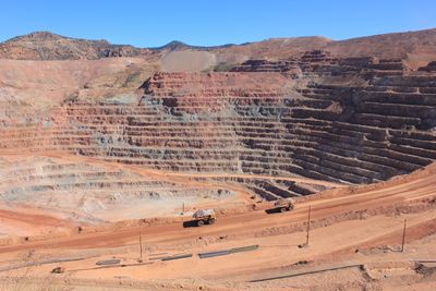
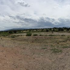
Morenci Mine, Copper surface mine in Greenlee County, Arizona, US

Description

Morenci Mine is a large-scale copper extraction operation in the Arizona desert. The landscape shows deep excavations, waste rock piles, and industrial infrastructure spread across a vast area.

History

The site began as an underground operation in 1871 and became an open-pit mine in 1937. This change allowed for large-scale industrial copper extraction in the region.

Culture

The mine created a complete community structure with residential areas, medical facilities, and commercial centers supporting over 3,300 mining workers.

Practical

Special permits are required to enter the active mining operation. Safety at the site is strictly regulated and visitors must follow all on-site guidance.

Did you know?

The mine contains mineral reserves of 3.2 billion tonnes of ore, making it one of North America's largest copper extraction sites.

GPS coordinates
33.09056,-109.36667
Latest update
December 7, 2025 19:29

AroundUs brings together thousands of curated places, local tips, and hidden gems, enriched daily by 60,000 contributors worldwide. Discover all places nearby (United States of America).

Around this place
Large Binocular Telescope
United States of America

Large Binocular Telescope

65.3 km
Vatican Advanced Technology Telescope
United States of America

Vatican Advanced Technology Telescope

65.5 km
Mount Graham
United States of America

Mount Graham

64 km
Mount Graham International Observatory
United States of America

Mount Graham International Observatory

65.5 km
Roper Lake State Park
United States of America

Roper Lake State Park

48.9 km
Heinrich Hertz Submillimeter Telescope
United States of America

Heinrich Hertz Submillimeter Telescope

65.4 km
Apache National Forest
United States of America

Apache National Forest

60.8 km
Gila Box Riparian National Conservation Area
United States of America

Gila Box Riparian National Conservation Area

21.7 km
Point of Pines Sites
United States of America

Point of Pines Sites

43.5 km
Park Avenue Bridge
United States of America

Park Avenue Bridge

7.4 km
L.C. Ranch Headquarters
United States of America

L.C. Ranch Headquarters

74.7 km
Whitewater Creek
United States of America

Whitewater Creek

51.2 km
Clifton Townsite Historic District
United States of America

Clifton Townsite Historic District

7.5 km
William Talley House
United States of America

William Talley House

43.4 km
Benjamin F. Billingsley House
United States of America

Benjamin F. Billingsley House

47.8 km
PS Knoll Lookout Complex
United States of America

PS Knoll Lookout Complex

74 km
Gila River Bridge
United States of America

Gila River Bridge

15 km
Graham County Courthouse
United States of America

Graham County Courthouse

43.4 km
Columbine Work Station
United States of America

Columbine Work Station

66.8 km
Mogollon Baldy Lookout Cabin
United States of America

Mogollon Baldy Lookout Cabin

74.7 km
Black Gap Bridge
United States of America

Black Gap Bridge

16.6 km
James R. Welker House
United States of America

James R. Welker House

43.6 km
Woman's Club
United States of America

Woman's Club

43 km
Cosmic Campground
United States of America

Cosmic Campground

59.9 km
Mogollon Baldy Lookout
United States of America

Mogollon Baldy Lookout

74.7 km
Chase Creek Railroad Bridge
United States of America

Chase Creek Railroad Bridge

7.2 km
Bearwallow Lookout
United States of America

Bearwallow Lookout

76.3 km
Clifton Railroad Bridge
United States of America

Clifton Railroad Bridge

8.1 km
Show the full map
« Morenci Mine - Copper surface mine in Greenlee County, Arizona, US » is provided by Around Us (aroundus.com). Images and texts are derived from Wikimedia project under a Creative Commons license. You are allowed to copy, distribute, and modify copies of this page, under the conditions set by the license, as long as this note is clearly visible.

Discover hidden gems everywhere you go!

From secret cafés to breathtaking viewpoints, skip the crowded tourist spots and find places that match your style. Our app makes it easy with voice search, smart filtering, route optimization, and insider tips from travelers worldwide. Download now for the complete mobile experience.

Around Us App Screenshot

A unique approach to discovering new places

Le Figaro

All the places worth exploring

France Info

A tailor-made excursion in just a few clicks

20 Minutes

Around Us
Travel Guide & Maps
Download

Send to your phone

QR Code
1

Open the camera app on your mobile.

2

Point at the QR code with your camera. A notification will appear.

3

Tap the notification to open the link.