Gila Box Riparian National Conservation Area

Log in to your account

AroundUs is a community-driven map of interesting places, built by curious explorers like you. It grows with every review, story, and photo you share.
Connect to save your favorite spots, contribute locations, and create personalized routes.
Continue with Google
Continue with Apple
Continue with X
Continue with Facebook
Continue with email
By continuing, you accept our Terms and Conditions and our Privacy Policy
Create an account

Gila Box Riparian National Conservation Area

Add to collection
Map
Suggest a change
Share

Gila Box Riparian National Conservation Area, National Conservation Area in Graham and Greenlee Counties, Arizona

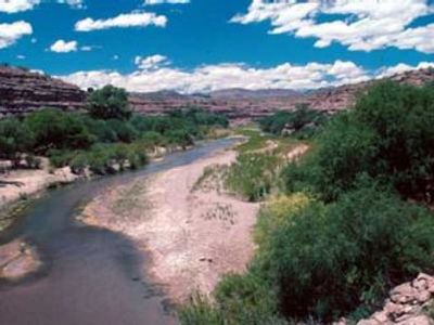
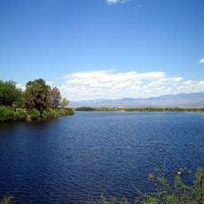
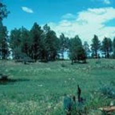
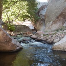
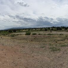
Gila Box Riparian National Conservation Area spans approximately 23,000 acres across two counties and is crossed by four year-round waterways: the Gila River, San Francisco River, and Bonita Creek with Eagle Creek. The landscape ranges in elevation from about 3,100 to 4,400 feet, while dramatic conglomerate cliffs frame the river corridors.

The area became a protected landscape in 1990 when the Bureau of Land Management established it to safeguard the riparian ecosystems along the Gila River in southeastern Arizona. This move recognized how vital these water-fed zones are for regional wildlife and the survival of species dependent on flowing water.

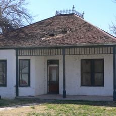
The land shows traces of centuries of human settlement along the waterways, including ancient dwellings, rock carvings, and structures that reveal how people lived in this landscape. These sites tell the story of those who relied on the rivers to survive and thrive.

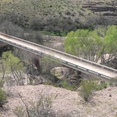
Riverview Campground offers tables, shade structures, grills, and bathrooms for basic camping needs, while primitive camping is allowed outside riparian zones throughout the conservation area. Visitors should know that road conditions and trail accessibility vary with the seasons and weather patterns in this region.

The Gila Conglomerate cliffs tower over 1,000 feet above the river, creating a dramatic backdrop where bighorn sheep roam beneath mesquite woodlands and mature cottonwoods. These towering rock faces shelter rare animal species that depend on this specific habitat and terrain.

Location: Graham County

Location: Greenlee County

Inception: 1990

GPS coordinates: 32.92200,-109.48400

Latest update: December 12, 2025 14:26

Photos
Around this place
Large Binocular Telescope
United States of America

Large Binocular Telescope

45.2 km
Vatican Advanced Technology Telescope
United States of America

Vatican Advanced Technology Telescope

45.4 km
Mount Graham
United States of America

Mount Graham

43.8 km
Morenci Mine
United States of America

Morenci Mine

21.7 km
Mount Graham International Observatory
United States of America

Mount Graham International Observatory

45.4 km
Sierra Bonita Ranch
United States of America

Sierra Bonita Ranch

69.4 km
Roper Lake State Park
United States of America

Roper Lake State Park

27.7 km
Heinrich Hertz Submillimeter Telescope
United States of America

Heinrich Hertz Submillimeter Telescope

45.3 km
Point of Pines Sites
United States of America

Point of Pines Sites

23.9 km
Rex Allen Arizona Cowboy Museum and Willcox Cowboy Hall of Fame
United States of America

Rex Allen Arizona Cowboy Museum and Willcox Cowboy Hall of Fame

81.3 km
Park Avenue Bridge
United States of America

Park Avenue Bridge

22.8 km
Whitewater Creek
United States of America

Whitewater Creek

70.8 km
Clifton Townsite Historic District
United States of America

Clifton Townsite Historic District

22.9 km
William Talley House
United States of America

William Talley House

23.5 km
Benjamin F. Billingsley House
United States of America

Benjamin F. Billingsley House

41.8 km
Gila River Bridge
United States of America

Gila River Bridge

17 km
Graham County Courthouse
United States of America

Graham County Courthouse

23.8 km
Columbine Work Station
United States of America

Columbine Work Station

46.9 km
Black Gap Bridge
United States of America

Black Gap Bridge

15.6 km
Johnson-Tillotson House
United States of America

Johnson-Tillotson House

81.3 km
John Gung'l House
United States of America

John Gung'l House

81.5 km
James R. Welker House
United States of America

James R. Welker House

23.7 km
Benjamin E. Briscoe House
United States of America

Benjamin E. Briscoe House

81.1 km
Woman's Club
United States of America

Woman's Club

23.3 km
Bowie School District No. 14
United States of America

Bowie School District No. 14

66.4 km
Cosmic Campground
United States of America

Cosmic Campground

81.2 km
Chase Creek Railroad Bridge
United States of America

Chase Creek Railroad Bridge

22.9 km
Clifton Railroad Bridge
United States of America

Clifton Railroad Bridge

22.7 km
Show the full map
Reviews

Visited this place? Tap the stars to rate it and share your experience / photos with the community! Try now! You can cancel it anytime.

« Gila Box Riparian National Conservation Area - National Conservation Area in Graham and Greenlee Counties, Arizona » is provided by Around Us (aroundus.com). Images and texts are derived from Wikimedia project under a Creative Commons license. You are allowed to copy, distribute, and modify copies of this page, under the conditions set by the license, as long as this note is clearly visible.

Discover hidden gems everywhere you go!

From secret cafés to breathtaking viewpoints, skip the crowded tourist spots and find places that match your style. Our app makes it easy with voice search, smart filtering, route optimization, and insider tips from travelers worldwide. Download now for the complete mobile experience.

Around Us App Screenshot

A unique approach to discovering new places

Le Figaro

All the places worth exploring

France Info

A tailor-made excursion in just a few clicks

20 Minutes