Escudilla Mountain

Log in to your account

AroundUs is a community-driven map of interesting places, built by curious explorers like you. It grows with every review, story, and photo you share.
Connect to save your favorite spots, contribute locations, and create personalized routes.
Continue with Google
Continue with Apple
Continue with X
Continue with Facebook
Continue with email
By continuing, you accept our Terms and Conditions and our Privacy Policy
Create an account
Add to collection
Map
Suggest a change
Share

Escudilla Mountain, Mountain summit in Apache County, Arizona

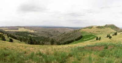
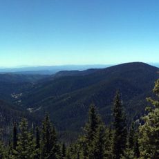
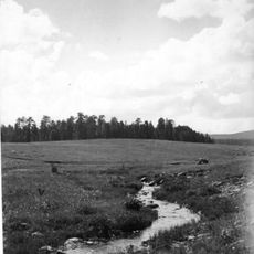
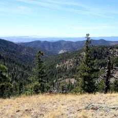
This peak reaches 10,916 feet and ranks among Arizona's highest mountains, with a broad summit crowned by expansive alpine meadows. The slopes are covered with dense aspen and pine forests that give way to open grassy areas as you approach the top.

This mountain holds significance in conservation history as the place where Arizona's last grizzly bear was killed in 1936. The event marked the end of an era and later prompted efforts to restore native wildlife to the region.

The name comes from Spanish, meaning 'large cup', reflecting the mountain's wide basin shape topped by high alpine meadows that stretch across its summit area.

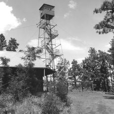
The main trail starts around 9,600 feet elevation and passes through forest and meadow sections with a steady climb to the summit. Weather at the top can change rapidly, particularly during summer storms, so starting early and watching the sky is important.

The area is home to reintroduced Mexican wolves, known as Lobos, which have returned to these mountains since the 1990s. These predators now play an important role in restoring the ecosystem balance in this part of the Southwest.

Location: Arizona

GPS coordinates: 33.95676,-109.12644

Latest update: December 11, 2025 11:06

Photos
Around this place
Morenci Mine
United States of America

Morenci Mine

99 km
Hawikuh Ruins
United States of America

Hawikuh Ruins

109.4 km
Mount Baldy
United States of America

Mount Baldy

40.7 km
Round Valley Ensphere
United States of America

Round Valley Ensphere

23.4 km
Kinishba Ruins
United States of America

Kinishba Ruins

87.2 km
Snowflake Arizona Temple
United States of America

Snowflake Arizona Temple

109.1 km
Lyman Reservoir
United States of America

Lyman Reservoir

49.9 km
Apache National Forest
United States of America

Apache National Forest

41.7 km
Casa Malpaís
United States of America

Casa Malpaís

26.8 km
Cedar Canyon Bridge
United States of America

Cedar Canyon Bridge

100.6 km
Park Avenue Bridge
United States of America

Park Avenue Bridge

101.5 km
Lake Mountain Lookout Complex
United States of America

Lake Mountain Lookout Complex

63.4 km
Butterfly Lodge
United States of America

Butterfly Lodge

30.6 km
Whitewater Creek
United States of America

Whitewater Creek

74.9 km
Eagar Townsite Historic District
United States of America

Eagar Townsite Historic District

22.7 km
Corduroy Creek Bridge
United States of America

Corduroy Creek Bridge

96.1 km
Clifton Townsite Historic District
United States of America

Clifton Townsite Historic District

101.6 km
Eagar School
United States of America

Eagar School

22.7 km
Los Burros Ranger Station
United States of America

Los Burros Ranger Station

62.4 km
PS Knoll Lookout Complex
United States of America

PS Knoll Lookout Complex

33.7 km
Mogollon Baldy Lookout Cabin
United States of America

Mogollon Baldy Lookout Cabin

90.8 km
Gallo Mountains
United States of America

Gallo Mountains

49.8 km
Cosmic Campground
United States of America

Cosmic Campground

56.3 km
Show Low Historical Society
United States of America

Show Low Historical Society

90.1 km
Chase Creek Railroad Bridge
United States of America

Chase Creek Railroad Bridge

101.4 km
Mogollon Baldy Lookout
United States of America

Mogollon Baldy Lookout

90.8 km
Bearwallow Lookout
United States of America

Bearwallow Lookout

70.6 km
Clifton Railroad Bridge
United States of America

Clifton Railroad Bridge

102.2 km
Show the full map
Reviews

Visited this place? Tap the stars to rate it and share your experience / photos with the community! Try now! You can cancel it anytime.

« Escudilla Mountain - Mountain summit in Apache County, Arizona » is provided by Around Us (aroundus.com). Images and texts are derived from Wikimedia project under a Creative Commons license. You are allowed to copy, distribute, and modify copies of this page, under the conditions set by the license, as long as this note is clearly visible.

Discover hidden gems everywhere you go!

From secret cafés to breathtaking viewpoints, skip the crowded tourist spots and find places that match your style. Our app makes it easy with voice search, smart filtering, route optimization, and insider tips from travelers worldwide. Download now for the complete mobile experience.

Around Us App Screenshot

A unique approach to discovering new places

Le Figaro

All the places worth exploring

France Info

A tailor-made excursion in just a few clicks

20 Minutes