Enable Location

We need your location to show you interesting places around you

Discover nearby places

Find interesting locations and hidden gems around you

Precise directions

Get accurate directions and distances to places

Your location is never shared with other users. It's only used when you tap the location button.

Brantley Lake State Park

Log in to your account

Start exploring — it's free

Trusted by 62,500 travelers worldwide

Continue with Google
Continue with Apple
or

We will send you a code to connect

By continuing, you accept our Terms and Conditions and our Privacy Policy

Check your inbox

We've sent a pincode in your inbox. Please enter the code below.

Brantley Lake State Park

Brantley Lake State Park, State park on Pecos River in Eddy County, US.

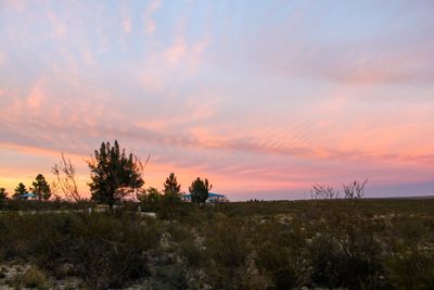
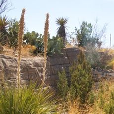
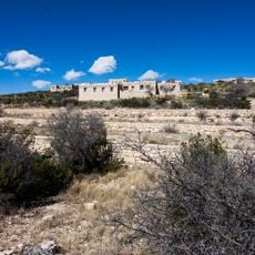
Brantley Lake State Park is a 1,200-acre recreation area built around a reservoir in the Pecos River Valley. Limestone cliffs and desert plants frame the shoreline, with multiple zones for boating, camping, and fishing spread throughout the grounds.

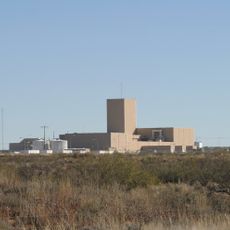
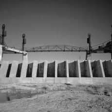
The park was established in 1989 when Brantley Dam was built to replace an older structure that no longer met safety standards. This dam project shaped how water has been managed in the region ever since.

The reservoir transformed how people in this valley use water and land, creating a new gathering place. Today visitors see this balance between human needs and the desert environment reflected in how the park is organized.

Access to recreation areas is easy through boat ramps and camping zones scattered across the grounds for different activities. Water levels and desert conditions change with the season, so plan your visit accordingly.

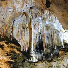
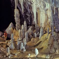
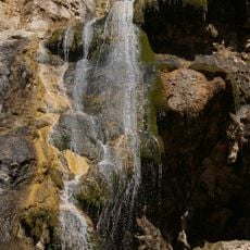
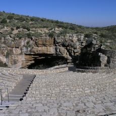
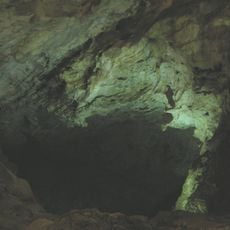
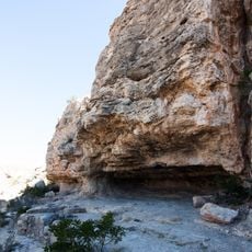
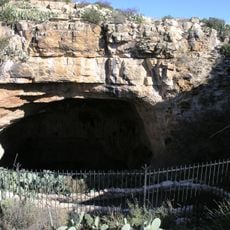
The eastern shore has three caves carved into gypsum deposits, each with its own distinctive formation. These hidden underground spaces offer a surprising discovery for visitors exploring beyond the water's edge.

The community of curious travelers

AroundUs brings together thousands of curated places, local tips, and hidden gems, enriched daily by 60,000 contributors worldwide.

Start exploring
Location
Inception
1989
GPS coordinates
32.55140,-104.38400
Latest update
December 11, 2025 11:08
Around this place
Carlsbad Caverns National Park
United States of America

Carlsbad Caverns National Park

42.2 km
Waste Isolation Pilot Plant
United States of America

Waste Isolation Pilot Plant

20.9 km
Lechuguilla Cave
United States of America

Lechuguilla Cave

41.7 km
Sitting Bull Falls
United States of America

Sitting Bull Falls

45 km
Abo Elementary School
United States of America

Abo Elementary School

31.5 km
Living Desert Zoo and Gardens State Park
United States of America

Living Desert Zoo and Gardens State Park

15.8 km
Rattlesnake Springs Historic District
United States of America

Rattlesnake Springs Historic District

49.8 km
The Caverns Historic District
United States of America

The Caverns Historic District

42 km
Carlsbad Irrigation District
United States of America

Carlsbad Irrigation District

14 km
Sallie Chisum Robert House
United States of America

Sallie Chisum Robert House

32.5 km
Moore-Ward Cobblestone House
United States of America

Moore-Ward Cobblestone House

32.1 km
Rio Felix Bridge at Hagerman
United States of America

Rio Felix Bridge at Hagerman

64.7 km
Ozark Trails Marker at Lake Arthur
United States of America

Ozark Trails Marker at Lake Arthur

49.8 km
Willie D. Atkeson House
United States of America

Willie D. Atkeson House

32 km
William Baskin House
United States of America

William Baskin House

32.3 km
Bat Flight Amphitheater
United States of America

Bat Flight Amphitheater

42 km
F. L. Lukins House
United States of America

F. L. Lukins House

32.2 km
Hodges-Runyan-Brainard House
United States of America

Hodges-Runyan-Brainard House

32.3 km
Mauldin-Hall House
United States of America

Mauldin-Hall House

31.9 km
Carlsbad Cavern
United States of America

Carlsbad Cavern

42 km
John Acord House
United States of America

John Acord House

32.4 km
Hodges-Sipple House
United States of America

Hodges-Sipple House

32 km
Indian Rock Shelter
United States of America

Indian Rock Shelter

40.7 km
Rattlesnake Springs Pump House
United States of America

Rattlesnake Springs Pump House

49.8 km
Eddy County Courthouse
United States of America

Eddy County Courthouse

20.6 km
Natural Entrance
United States of America

Natural Entrance

42 km
Avalon Dam Suspension Bridge
United States of America

Avalon Dam Suspension Bridge

14.1 km
Cottonwood Day Use Area
United States of America

Cottonwood Day Use Area

51.4 km
Show the full map
« Brantley Lake State Park - State park on Pecos River in Eddy County, US » is provided by Around Us (aroundus.com). Images and texts are derived from Wikimedia project under a Creative Commons license. You are allowed to copy, distribute, and modify copies of this page, under the conditions set by the license, as long as this note is clearly visible.

Discover hidden gems everywhere you go!

From secret cafés to breathtaking viewpoints, skip the crowded tourist spots and find places that match your style. Our app makes it easy with voice search, smart filtering, route optimization, and insider tips from travelers worldwide. Download now for the complete mobile experience.

Around Us App Screenshot

A unique approach to discovering new places

Le Figaro

All the places worth exploring

France Info

A tailor-made excursion in just a few clicks

20 Minutes

Around Us
Travel Guide & Maps
Download

Send to your phone

QR Code
1

Open the camera app on your mobile.

2

Point at the QR code with your camera. A notification will appear.

3

Tap the notification to open the link.