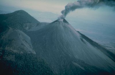
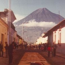
Pacaya, Active volcano in Escuintla Department, Guatemala.
Pacaya is an active volcano in Escuintla Department, Guatemala, rising to 2552 meters (8373 feet) as part of the Central American Volcanic Arc. Multiple craters mark its summit, from which continuous plumes of smoke rise, while solidified lava flows descend the flanks and form a barren lunar landscape.
After 70 years of rest, the volcano began a new phase in 1961 with repeated eruptions that continue to this day. Major eruptions in the 1960s changed the shape of the summit and forced people in surrounding villages to relocate.
The name comes from the Mayan language and is used with respect by locals, as this mountain has shaped daily life for generations. Residents of the surrounding villages work as mountain guides and share their experience with visitors during the shared hikes through the lava fields.
Access to the national park costs 100 quetzales, and hikers should check current conditions via INSIVUMEH before starting the climb. Sturdy footwear and warm clothing are advisable, as wind and cool temperatures prevail near the summit, even though the approach begins in tropical heat.
At certain spots on the slopes, heat from volcanic fissures reaches temperatures sufficient to roast or cook food. Some guides show visitors these natural oven sites and prepare marshmallows or small snacks there.
Location: Escuintla Department
Inception: 1956
Elevation above the sea: 2,552 m
GPS coordinates: 14.38211,-90.60166
Latest update: December 12, 2025 18:13
Guatemala offers photographers a mix of pre-Columbian sites, volcanic landscapes, and colonial buildings. The geography ranges from highland towns to rainforests and coastal areas along the Pacific and Caribbean. Ancient Maya temples stand alongside Spanish-era churches, while indigenous markets and...
Guatemala contains several photographic subjects within its borders. Maya ruins such as Tikal, Yaxha and Quiriguá stand in the tropical forests of Petén and Izabal. Colonial architecture appears in Antigua Guatemala, where the Santa Catalina Arch and painted facades line cobblestone streets. Lake...
Volcán de Agua
17.8 km
IRTRA Mundo Petapa
22.2 km
Antigua Guatemala Cathedral
24 km
Church and Convent of Capuchins
24.2 km
Casa de Dios
19.4 km
Palacio de los Capitanes Generales
24 km
Castillo de Dorión
11.2 km
Ayuntamiento of Antigua Guatemala
24.1 km
Church and Convent of Society of Jesus
24.3 km
Iglesia del Calvario
22.3 km
College of the Company of Jesus
24.3 km
Candelaria Parrish
24.3 km
Estadio Municipal de San Miguel Petapa
14.1 km
El Calvario Church
22.8 km
Torres ECHO
23.4 km
Estadio Revolución Ciudad de Guatemala
23.5 km
Casa Popenoe
23.8 km
Ermita de Santa Isabel de Hungría
22.7 km
Santa Isabel
19.5 km
Estadio Municipal de Bárcena
18 km
Café de la Escalonia
23.5 km
Intecap Escuintla 1
22.4 km
Finca el barretal
7.1 km
Royal Palace of the Captains General
24 km
Iglesia Santa Elisa
23.3 km
MUNAG - Museo Nacional de Arte de Guatemala
24 km
Lantana Tower
22.9 km
Tiffany Novena
24.3 kmVisited this place? Tap the stars to rate it and share your experience / photos with the community! Try now! You can cancel it anytime.
Discover hidden gems everywhere you go!
From secret cafés to breathtaking viewpoints, skip the crowded tourist spots and find places that match your style. Our app makes it easy with voice search, smart filtering, route optimization, and insider tips from travelers worldwide. Download now for the complete mobile experience.
A unique approach to discovering new places❞
— Le Figaro
All the places worth exploring❞
— France Info
A tailor-made excursion in just a few clicks❞
— 20 Minutes