See the monuments around you in AROpen chests in the app
Around Us is built for your phone — point your camera at the streets and discover the monuments and places around you in augmented reality.Around Us is built for your phone — chests unlock when you walk, explore and capture nearby places.
Guatemala offers photographers a mix of pre-Columbian sites, volcanic landscapes, and colonial buildings. The geography ranges from highland towns to rainforests and coastal areas along the Pacific and Caribbean. Ancient Maya temples stand alongside Spanish-era churches, while indigenous markets and traditional villages show cultural life. The landscape is marked by active and dormant volcanoes, often surrounded by coffee plantations. Places like Antigua Guatemala display colonial architecture with cobblestone streets and courtyards. Lake Atitlán sits between mountains and smaller communities. Tikal and other archaeological sites in the north preserve Maya structures within jungle settings. Chichicastenango Market is known for woven textiles and incense. Pacaya and Acatenango are accessible volcanoes, while Semuc Champey offers natural pools in a limestone forest. The variety of regions makes Guatemala a country with different perspectives in short distances.
Guatemala offers photographers a mix of pre-Columbian sites, volcanic landscapes, and colonial buildings. The geography ranges from highland towns to rainforests and coastal areas along the Pacific and Caribbean. Ancient Maya temples stand alongside Spanish-era churches, while indigenous markets and traditional villages show cultural life. The landscape is marked by active and dormant volcanoes, often surrounded by coffee plantations. Places like Antigua Guatemala display colonial architecture with cobblestone streets and courtyards. Lake Atitlán sits between mountains and smaller communities. Tikal and other archaeological sites in the north preserve Maya structures within jungle settings. Chichicastenango Market is known for woven textiles and incense. Pacaya and Acatenango are accessible volcanoes, while Semuc Champey offers natural pools in a limestone forest. The variety of regions makes Guatemala a country with different perspectives in short distances.
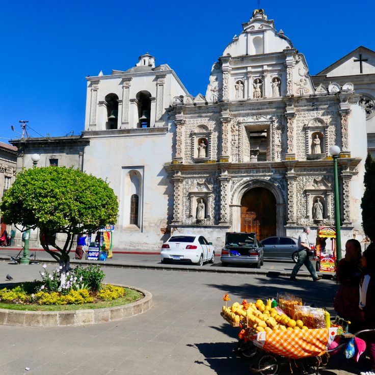
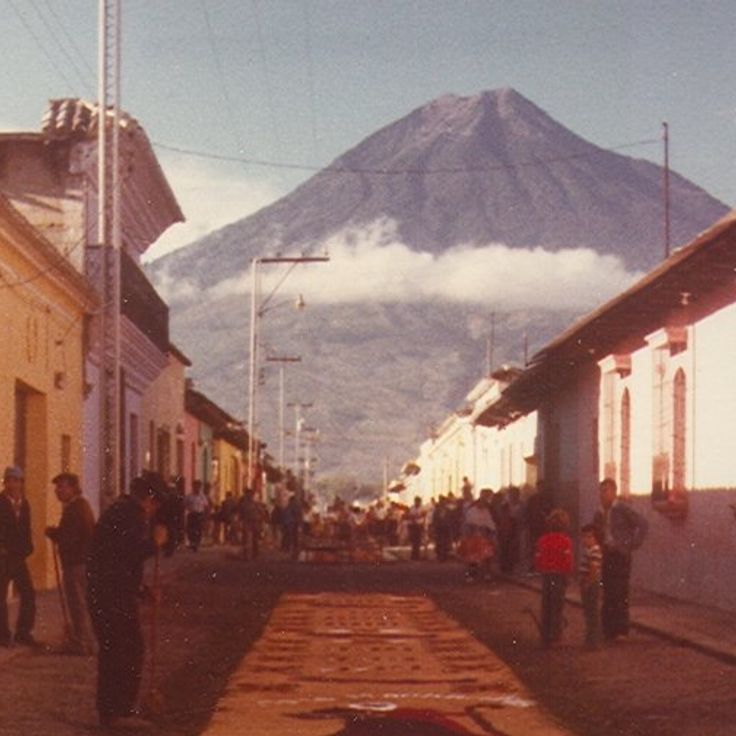
This city offers Spanish colonial churches and buildings from the 16th century, cobblestone streets and a view of three volcanic peaks: Agua, Fuego and Acatenango. Antigua Guatemala shows courtyards with fountains, pastel-colored facades and ruins of old monasteries marked by earthquakes. The streets lead through shaded plazas where vendors sell local textiles and ceramics.
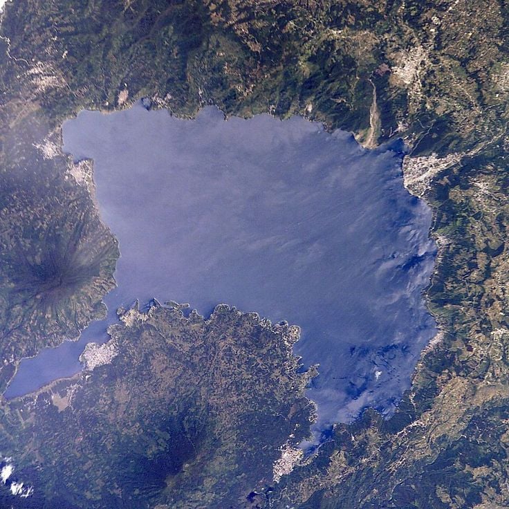
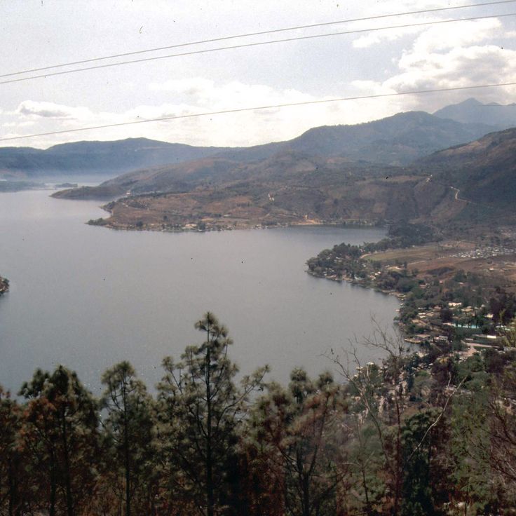
This volcanic lake sits at 5125 feet (1562 meters) above sea level and is framed by three volcanoes: Atitlán, Tolimán and San Pedro. Villages along the shore preserve Maya traditions, while the water shifts in shades of blue depending on the light. Fishing boats cross the lake in the morning, and steep slopes drop down to the waterline. The lake formed about 84,000 years ago from a volcanic eruption and now provides a natural backdrop for photographs of villages, textile markets and terraced fields.
This volcano delivers photographers regular active lava flows and raw landscapes with fresh rock formations. The trails cross black volcanic stone and offer views over the surrounding fields and villages. The crater sometimes shows glowing spots, and the temperature rises when approaching the eruption zones. Pacaya Volcano releases smoke and changes shape through frequent eruptions, adding a dynamic element to photography.
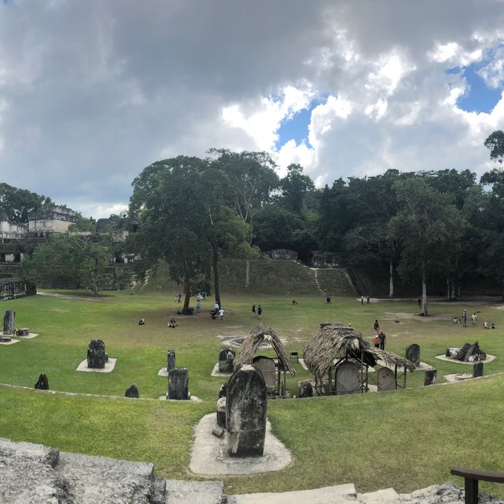
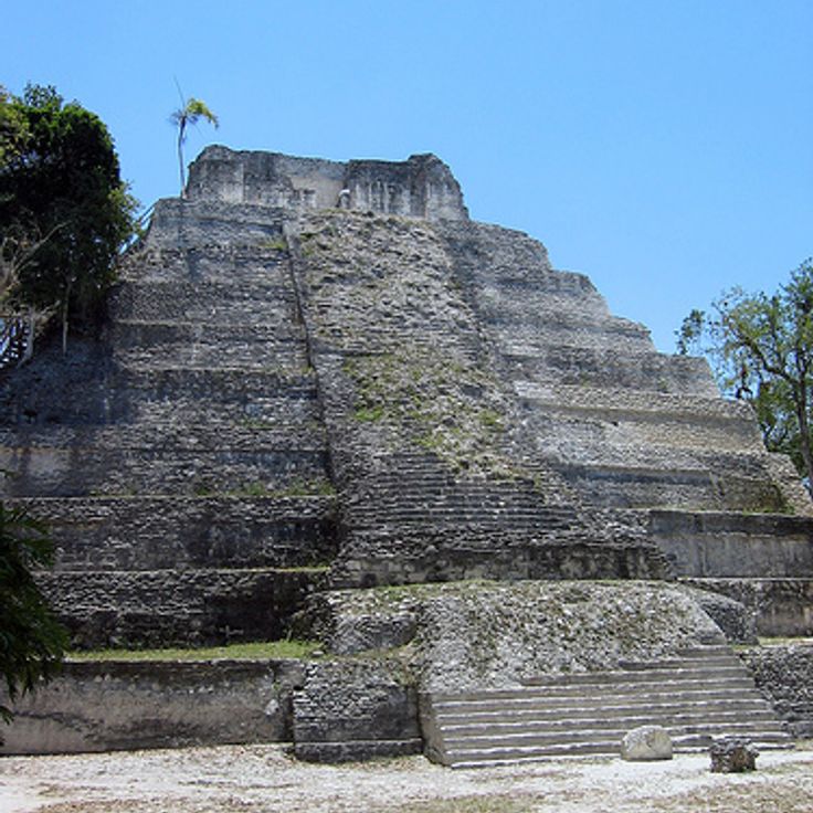
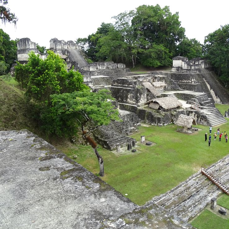
This national park preserves one of the largest Maya cities from the 6th century. The pyramids and temples rise above the rainforest and offer photographers wide views over the canopy. Howler monkeys and toucans live among the ruins. Morning light filters through the trees onto the stone structures and creates contrasts between nature and ancient architecture. The temple platforms allow shots of the surrounding forests and other buildings. Mist sometimes rises between the treetops and adds another dimension to photographic compositions.
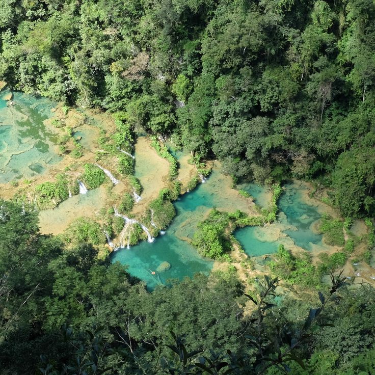
This natural limestone bridge over the Cahabón River forms terraced pools filled with turquoise water. Semuc Champey sits in the jungle of Alta Verapaz and offers photographers a chance to capture the interplay between river flow and tropical vegetation. Water cascades across multiple levels and collects in calm pools while the river continues its course underneath.
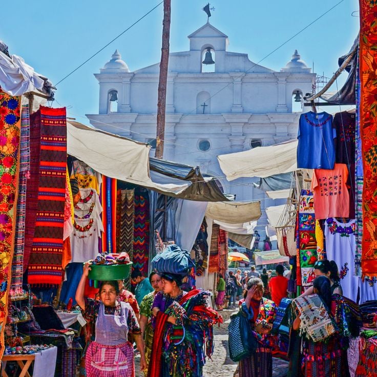
This market shows daily life among Maya communities in the highlands. Vendors offer hand-woven textiles, pottery, masks and fruit beneath tarps. Women in traditional clothing bargain over prices. Copal smoke drifts between the stalls. The church of Santo Tomás stands on the west side of the square. On Thursdays and Sundays farmers arrive from surrounding villages with their goods.
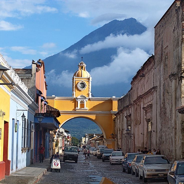
This colonial arch from the 17th century once connected two convent buildings and created a covered passage for the nuns. Photographers appreciate the framed view of Agua volcano through the arch, which represents a typical scene of the town. The yellow facade and the clock on the upper part, combined with the cobblestone street and surrounding facades, form a characteristic colonial townscape of Guatemala.
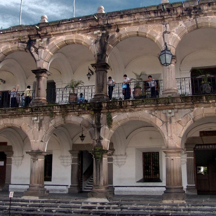
This city square shows 19th century architecture with a theater, a government palace and a cathedral. Quetzaltenango sits in the highlands of Guatemala and offers photographers colonial facades, religious buildings and public spaces where daily city life unfolds. The structures around the square reflect the style favored during the republican era.
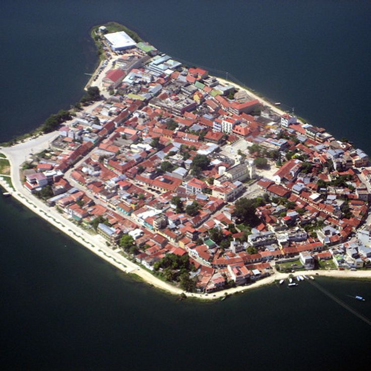
This island on Lake Petén Itzá shows houses in different colors with red roofs along narrow stone streets. The architecture and compact layout on the water create photo subjects with Guatemalan colonial aesthetics. From the shores the settlement appears as a colored ensemble above the lake, while the streets inside offer perspectives through arches and facades.
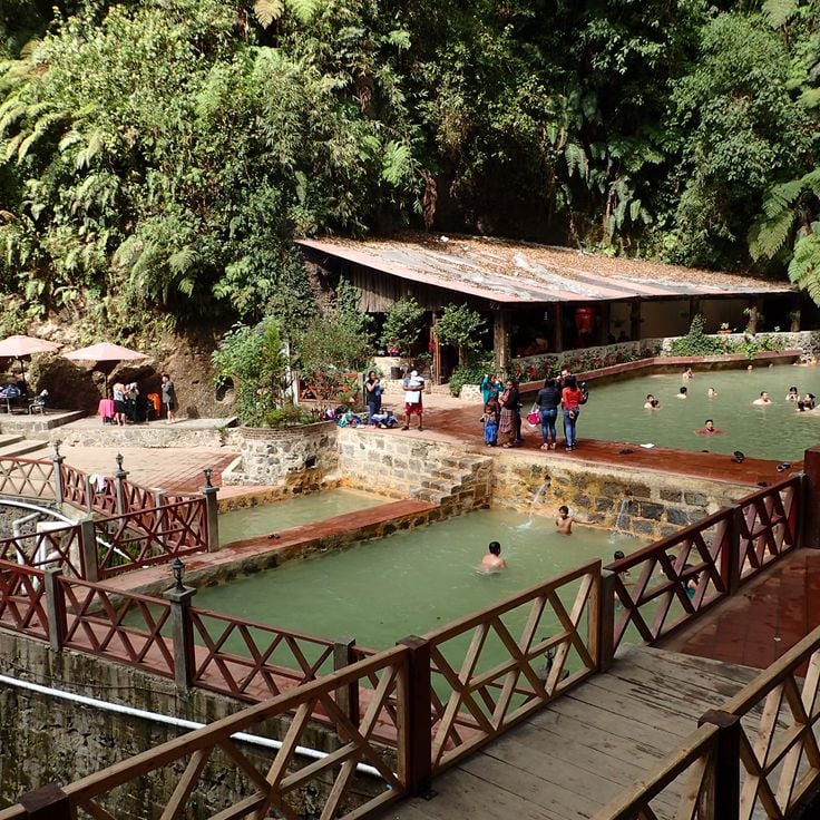
These thermal pools sit in the mountains at 7200 feet (2200 meters) elevation, surrounded by dense vegetation. Morning mists rise between the trees as warm water steams in natural basins. Fuentes Georginas gives photographers the chance to capture the combination of volcanic activity and tropical plant life that defines Guatemala's highlands.
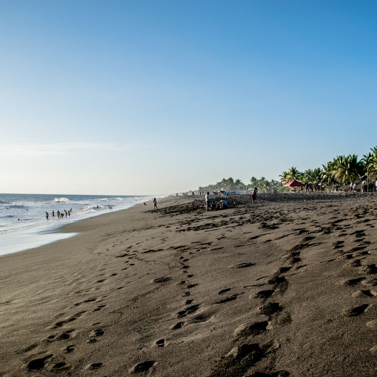
This Pacific coast beach consists of black volcanic sand. The water at Monterrico Beach retreats far at low tide, exposing smooth, dark flats. Waves break steadily and the ocean often carries driftwood and shells ashore. Palms and low vegetation grow along the dunes, where fishermen spread their nets and boats rest between the trees.
This Maya site preserves 500 structures from the Classic period along Lake Yaxhá. Visitors walk among stone pyramids, open plazas and temples. The grounds extend through tropical forest, and several structures provide views over the water and treetops. Yaxhá lies away from the main routes, allowing for quiet exploration without crowds. Photography in Guatemala often combines archaeology with nature, and these ruins offer both elements. Birds call between the stones, and light filters down through the canopy overhead.
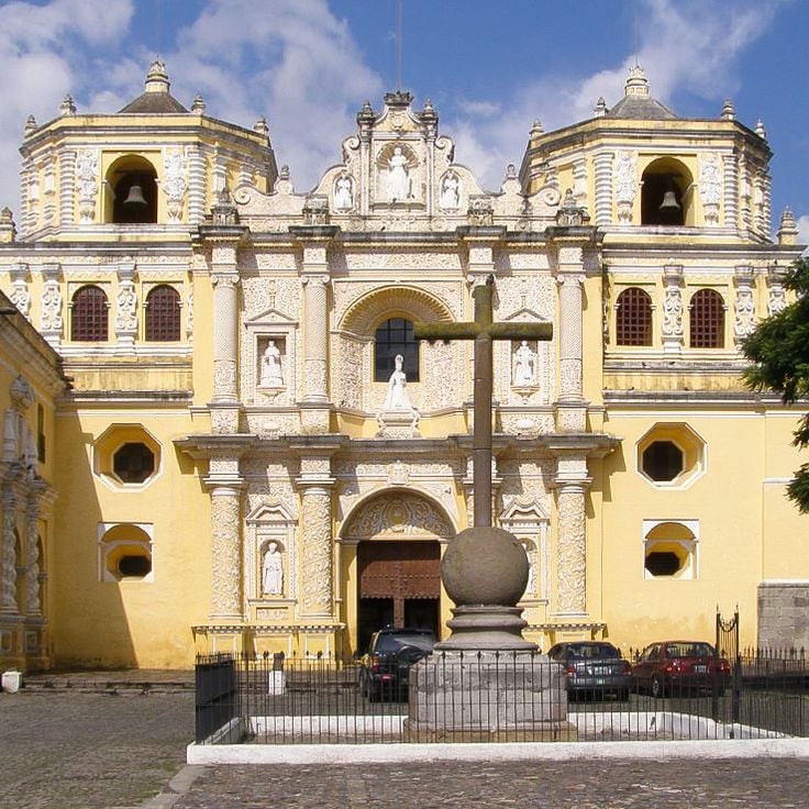
This church dates from the 18th century and shows baroque architecture with yellow and white exterior walls typical of Antigua. The facade carries columns, stucco work and religious motifs that represent Spanish colonial art in Guatemala. La Merced works well for photographs of church portals, shadows on the walls and details of the decoration. Morning or late afternoon light brings out the colors and textures.
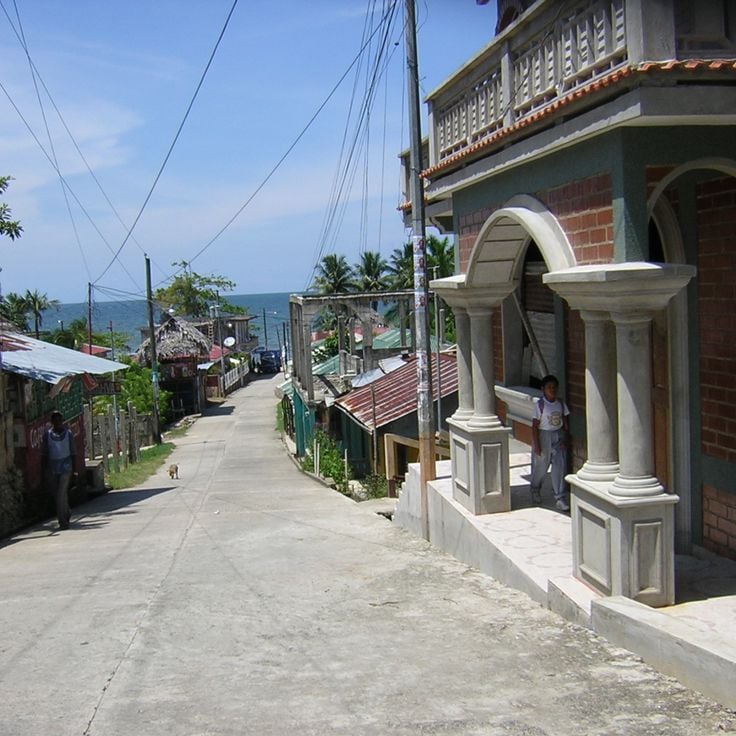
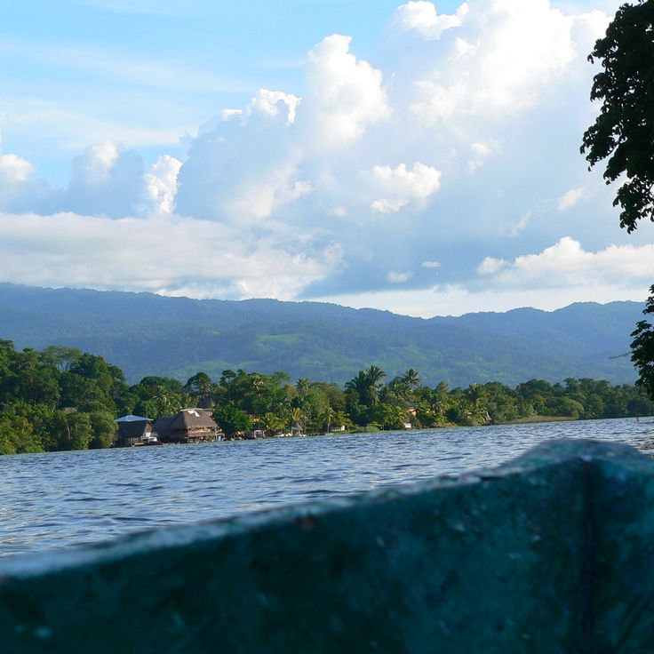
This coastal town in Izabal combines Caribbean atmosphere with the culture of the Garifuna community. Livingston is only reachable by boat and shows African, indigenous and Caribbean influences in its music, dances and food. Photographers find wooden houses on stilts, fishermen laying out their nets and street scenes with marimba sounds. The presence of palm trees, colorful facades and the slow-moving Río Dulce river creates tropical subjects. Tapado, a seafood stew with coconut milk, and freshly baked coconut bread are part of daily life and often sold on the street.
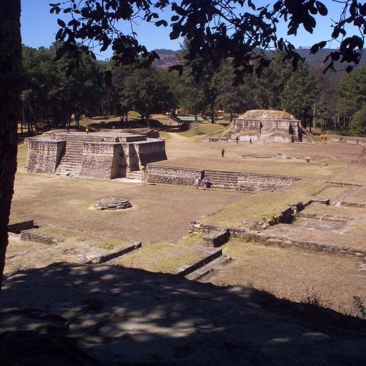
This Maya archaeological site from the 15th century displays temples, plazas and ball courts set among green hills. Iximché once served as the capital of the Kaqchikel kingdom and now offers a quiet place where visitors walk among stone ruins, photograph details of ancient architecture and take in views across the highlands.
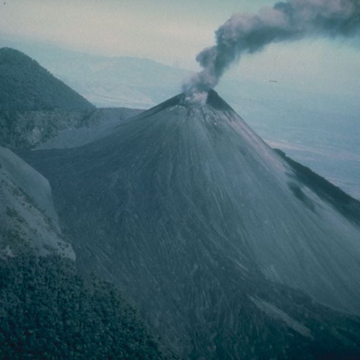
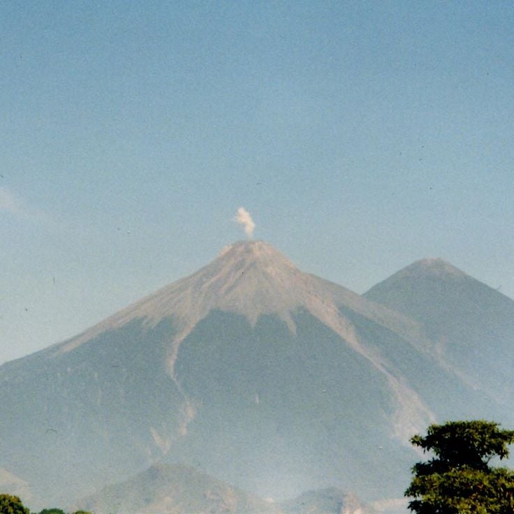
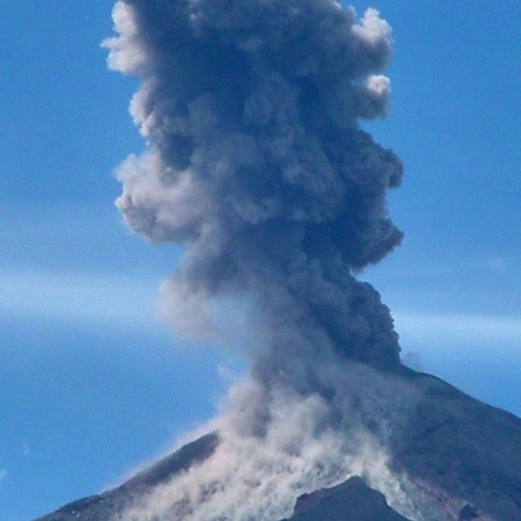
This 3976-meter (13,044-foot) volcano in the central highlands offers trails through pine forests that lead to viewpoints overlooking the active Fuego. Fuego regularly releases ash and lava, creating visible eruptions throughout the day and night. The climb takes several hours and passes through changing vegetation zones. Photographers come here to capture the eruptions at sunrise or after dark, when the glowing lava flows are most visible against the sky.
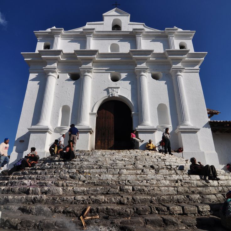
This 16th century church combines Catholic and Maya traditions in a place where smoke from incense rises over white stone stairs. The large front courtyard often fills with people lighting candles and laying flowers. Inside, silver votive offerings hang from the walls, while outside vendors spread their goods. The steps serve as an open-air prayer space where shamans perform traditional ceremonies. Photographers find scenes of religious rituals, colorful textiles, and the meeting of two belief systems.
This historical plaza in Tikal displays Maya architecture with stone pyramids and temples arranged to create specific sound distribution. The plaza sits at the heart of the ancient city and serves as a central space between several major structures. Visitors experience the proportions and interplay of the buildings, which were designed for open sight lines and ceremonial functions. Photographers find soft morning light that brings out the textures of the stone and casts shadows emphasizing the architectural details.
This national park connects waterways with tropical vegetation and the 17th century Castillo de San Felipe fortress. Rivers wind through dense forest, passing shoreline growth and limestone formations. The Spanish fort watches over the river mouth and offers views across water and jungle. Photographers find subjects in colonial architecture, forest landscapes and river scenes. The combination of historical buildings and natural surroundings creates varied compositions between water, greenery and stone. Light filters through canopy and reflects off moving currents throughout the day.
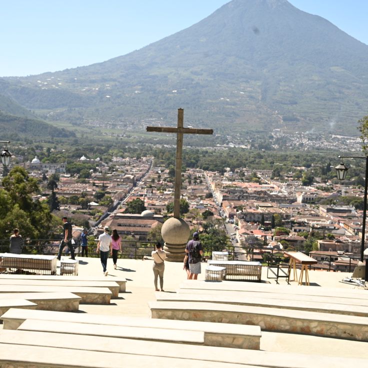
Cerro de la Cruz is a monument on a mountaintop with views over the colonial city of Antigua. From here you see the three volcanoes Agua, Fuego and Acatenango. The spot sits about 500 feet (150 meters) above the city. Visitors come in the morning or late afternoon. The view shows the cobbled streets and colored roofs of Antigua. On clear days the volcanic cones stand out against the sky. A short path leads from the edge of town up to the cross.
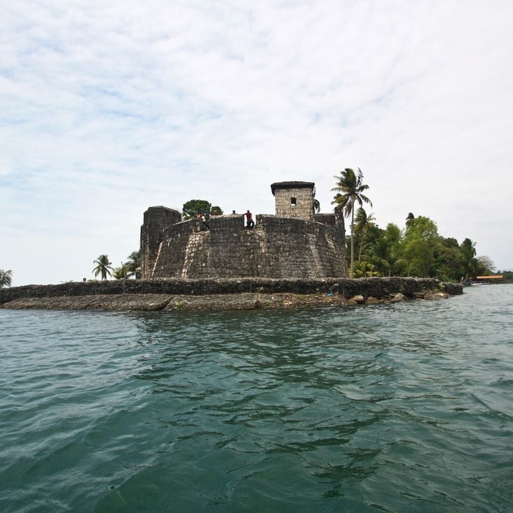
This fortress from 1652 was built as a Spanish military post on the Rio Dulce to protect trade routes from Caribbean pirates. The structure is made of solid stone walls and shows the military architecture of the colonial period. Seen from the water, the fort looks compact and defensive, with small openings in the thick walls. Its location on the river makes it an interesting subject for photographers drawn to historical buildings and colonial history in Guatemala.
This town on the shores of Lake Atitlán maintains the traditions of the Tz'utujil Maya. Santiago Atitlán is known for its weaving, using natural dyes and patterns passed down through families. The church at the main square combines colonial architecture with indigenous art. The market sells textiles, pottery and produce from the surrounding hills. Religious life blends Catholic celebrations with Maya ceremonies that honor local deities.
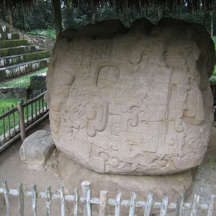
This archaeological park preserves Maya monuments from the 8th century. The site shows carved stelae and zoomorphic stones found here. The inscriptions offer insight into regional history and document events from that period. Visitors see the stonework under tropical trees. The ruins sit in a flat area where a city once stood.
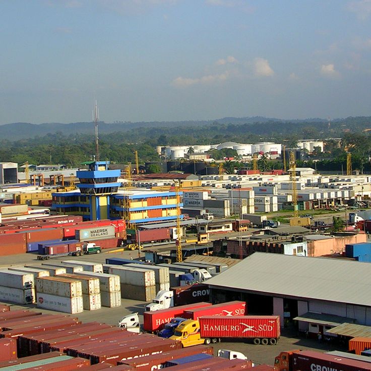
This commercial port on the Caribbean coast connects Guatemala's interior to the sea through container terminals and a cruise ship facility. The fish market sells daily catches of seafood brought in by fishermen from Caribbean waters. Warehouses and cranes mark the harbor area. Small stands near the docks offer local snacks and drinks for port workers and visitors.
This active volcano attracts scientists who work from observation platforms located at about 1500 meters away. The research station at Santiaguito documents the movements of the lava dome formations, making it a location for volcano photography in Guatemala where steam clouds and occasional eruptions shape the landscape.
This volcano rises in the Chiquimula region and holds a crater lake at 1650 meters elevation (5400 feet). Pine forests cover the slopes while open grasslands mark the upper reaches. The hike to the summit passes through different vegetation zones, and the lake inside the crater shows changing colors depending on the time of day and weather. Photographers find subjects ranging from tropical vegetation in the lowlands to cooler elevations with views across the surrounding Guatemalan landscape.
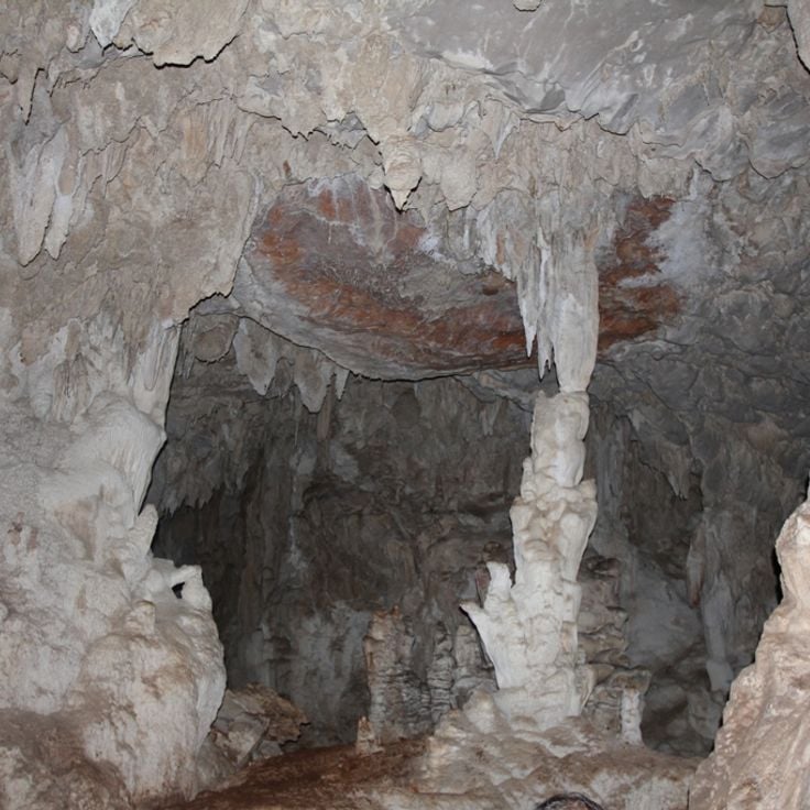
This cave system stretches for about 14 miles (22 kilometers) and is crossed by underground rivers. The walls of Candelaria Caves display white and orange mineral deposits. For photographers, the formations and the play of light and shadow inside the chambers offer an exceptional subject in the highlands of Guatemala.
The Agua Volcano rises 3,760 meters (12,336 feet) above Antigua Guatemala and forms one of the recognizable silhouettes on the horizon. Marked hiking trails pass through different forest zones that change with elevation, offering views over the colonial city and surrounding valleys. The slopes show varying vegetation, from dense tree cover in the lower sections to more open areas higher up. The climb takes several hours and is often done with local guides who know the route and conditions. From different points, you can photograph the cone-shaped summit, especially in clear weather during the morning or late afternoon.
This freshwater lake sits in a volcanic basin, surrounded by green hills. Restaurants along the shore serve local dishes while boats carry guests across the water. Fishermen cast their nets here, and visitors can enjoy views of the surrounding volcanoes. Lake Amatitlán offers quiet moments by the water and a chance to see the Guatemalan landscape from a different angle.
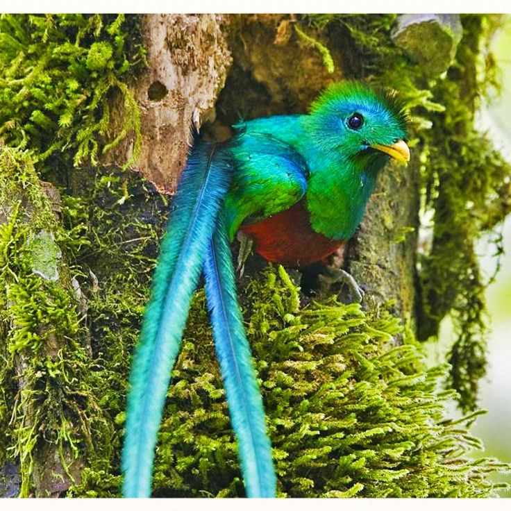
This cloud forest sits between two larger towns and provides a home for the quetzal, Guatemala's national bird. The trails wind through dense vegetation with ferns, mosses and many orchid species. Birdwatchers arrive early in the morning when visibility is best and the birds are active. The reserve protects one of the last remaining habitats for these feathered creatures in Central America.
This city offers Spanish colonial churches and buildings from the 16th century, cobblestone streets and a view of three volcanic peaks: Agua, Fuego and Acatenango. Antigua Guatemala shows courtyards with fountains, pastel-colored facades and ruins of old monasteries marked by earthquakes. The streets lead through shaded plazas where vendors sell local textiles and ceramics.
This volcanic lake sits at 5125 feet (1562 meters) above sea level and is framed by three volcanoes: Atitlán, Tolimán and San Pedro. Villages along the shore preserve Maya traditions, while the water shifts in shades of blue depending on the light. Fishing boats cross the lake in the morning, and steep slopes drop down to the waterline. The lake formed about 84,000 years ago from a volcanic eruption and now provides a natural backdrop for photographs of villages, textile markets and terraced fields.
This volcano delivers photographers regular active lava flows and raw landscapes with fresh rock formations. The trails cross black volcanic stone and offer views over the surrounding fields and villages. The crater sometimes shows glowing spots, and the temperature rises when approaching the eruption zones. Pacaya Volcano releases smoke and changes shape through frequent eruptions, adding a dynamic element to photography.
This national park preserves one of the largest Maya cities from the 6th century. The pyramids and temples rise above the rainforest and offer photographers wide views over the canopy. Howler monkeys and toucans live among the ruins. Morning light filters through the trees onto the stone structures and creates contrasts between nature and ancient architecture. The temple platforms allow shots of the surrounding forests and other buildings. Mist sometimes rises between the treetops and adds another dimension to photographic compositions.
This natural limestone bridge over the Cahabón River forms terraced pools filled with turquoise water. Semuc Champey sits in the jungle of Alta Verapaz and offers photographers a chance to capture the interplay between river flow and tropical vegetation. Water cascades across multiple levels and collects in calm pools while the river continues its course underneath.
This market shows daily life among Maya communities in the highlands. Vendors offer hand-woven textiles, pottery, masks and fruit beneath tarps. Women in traditional clothing bargain over prices. Copal smoke drifts between the stalls. The church of Santo Tomás stands on the west side of the square. On Thursdays and Sundays farmers arrive from surrounding villages with their goods.
This colonial arch from the 17th century once connected two convent buildings and created a covered passage for the nuns. Photographers appreciate the framed view of Agua volcano through the arch, which represents a typical scene of the town. The yellow facade and the clock on the upper part, combined with the cobblestone street and surrounding facades, form a characteristic colonial townscape of Guatemala.
This city square shows 19th century architecture with a theater, a government palace and a cathedral. Quetzaltenango sits in the highlands of Guatemala and offers photographers colonial facades, religious buildings and public spaces where daily city life unfolds. The structures around the square reflect the style favored during the republican era.
This island on Lake Petén Itzá shows houses in different colors with red roofs along narrow stone streets. The architecture and compact layout on the water create photo subjects with Guatemalan colonial aesthetics. From the shores the settlement appears as a colored ensemble above the lake, while the streets inside offer perspectives through arches and facades.
These thermal pools sit in the mountains at 7200 feet (2200 meters) elevation, surrounded by dense vegetation. Morning mists rise between the trees as warm water steams in natural basins. Fuentes Georginas gives photographers the chance to capture the combination of volcanic activity and tropical plant life that defines Guatemala's highlands.
This Pacific coast beach consists of black volcanic sand. The water at Monterrico Beach retreats far at low tide, exposing smooth, dark flats. Waves break steadily and the ocean often carries driftwood and shells ashore. Palms and low vegetation grow along the dunes, where fishermen spread their nets and boats rest between the trees.
This Maya site preserves 500 structures from the Classic period along Lake Yaxhá. Visitors walk among stone pyramids, open plazas and temples. The grounds extend through tropical forest, and several structures provide views over the water and treetops. Yaxhá lies away from the main routes, allowing for quiet exploration without crowds. Photography in Guatemala often combines archaeology with nature, and these ruins offer both elements. Birds call between the stones, and light filters down through the canopy overhead.
This church dates from the 18th century and shows baroque architecture with yellow and white exterior walls typical of Antigua. The facade carries columns, stucco work and religious motifs that represent Spanish colonial art in Guatemala. La Merced works well for photographs of church portals, shadows on the walls and details of the decoration. Morning or late afternoon light brings out the colors and textures.
This coastal town in Izabal combines Caribbean atmosphere with the culture of the Garifuna community. Livingston is only reachable by boat and shows African, indigenous and Caribbean influences in its music, dances and food. Photographers find wooden houses on stilts, fishermen laying out their nets and street scenes with marimba sounds. The presence of palm trees, colorful facades and the slow-moving Río Dulce river creates tropical subjects. Tapado, a seafood stew with coconut milk, and freshly baked coconut bread are part of daily life and often sold on the street.
This Maya archaeological site from the 15th century displays temples, plazas and ball courts set among green hills. Iximché once served as the capital of the Kaqchikel kingdom and now offers a quiet place where visitors walk among stone ruins, photograph details of ancient architecture and take in views across the highlands.
This 3976-meter (13,044-foot) volcano in the central highlands offers trails through pine forests that lead to viewpoints overlooking the active Fuego. Fuego regularly releases ash and lava, creating visible eruptions throughout the day and night. The climb takes several hours and passes through changing vegetation zones. Photographers come here to capture the eruptions at sunrise or after dark, when the glowing lava flows are most visible against the sky.
This 16th century church combines Catholic and Maya traditions in a place where smoke from incense rises over white stone stairs. The large front courtyard often fills with people lighting candles and laying flowers. Inside, silver votive offerings hang from the walls, while outside vendors spread their goods. The steps serve as an open-air prayer space where shamans perform traditional ceremonies. Photographers find scenes of religious rituals, colorful textiles, and the meeting of two belief systems.
This historical plaza in Tikal displays Maya architecture with stone pyramids and temples arranged to create specific sound distribution. The plaza sits at the heart of the ancient city and serves as a central space between several major structures. Visitors experience the proportions and interplay of the buildings, which were designed for open sight lines and ceremonial functions. Photographers find soft morning light that brings out the textures of the stone and casts shadows emphasizing the architectural details.
This national park connects waterways with tropical vegetation and the 17th century Castillo de San Felipe fortress. Rivers wind through dense forest, passing shoreline growth and limestone formations. The Spanish fort watches over the river mouth and offers views across water and jungle. Photographers find subjects in colonial architecture, forest landscapes and river scenes. The combination of historical buildings and natural surroundings creates varied compositions between water, greenery and stone. Light filters through canopy and reflects off moving currents throughout the day.
Cerro de la Cruz is a monument on a mountaintop with views over the colonial city of Antigua. From here you see the three volcanoes Agua, Fuego and Acatenango. The spot sits about 500 feet (150 meters) above the city. Visitors come in the morning or late afternoon. The view shows the cobbled streets and colored roofs of Antigua. On clear days the volcanic cones stand out against the sky. A short path leads from the edge of town up to the cross.
This fortress from 1652 was built as a Spanish military post on the Rio Dulce to protect trade routes from Caribbean pirates. The structure is made of solid stone walls and shows the military architecture of the colonial period. Seen from the water, the fort looks compact and defensive, with small openings in the thick walls. Its location on the river makes it an interesting subject for photographers drawn to historical buildings and colonial history in Guatemala.
This town on the shores of Lake Atitlán maintains the traditions of the Tz'utujil Maya. Santiago Atitlán is known for its weaving, using natural dyes and patterns passed down through families. The church at the main square combines colonial architecture with indigenous art. The market sells textiles, pottery and produce from the surrounding hills. Religious life blends Catholic celebrations with Maya ceremonies that honor local deities.
This archaeological park preserves Maya monuments from the 8th century. The site shows carved stelae and zoomorphic stones found here. The inscriptions offer insight into regional history and document events from that period. Visitors see the stonework under tropical trees. The ruins sit in a flat area where a city once stood.
This commercial port on the Caribbean coast connects Guatemala's interior to the sea through container terminals and a cruise ship facility. The fish market sells daily catches of seafood brought in by fishermen from Caribbean waters. Warehouses and cranes mark the harbor area. Small stands near the docks offer local snacks and drinks for port workers and visitors.
This active volcano attracts scientists who work from observation platforms located at about 1500 meters away. The research station at Santiaguito documents the movements of the lava dome formations, making it a location for volcano photography in Guatemala where steam clouds and occasional eruptions shape the landscape.
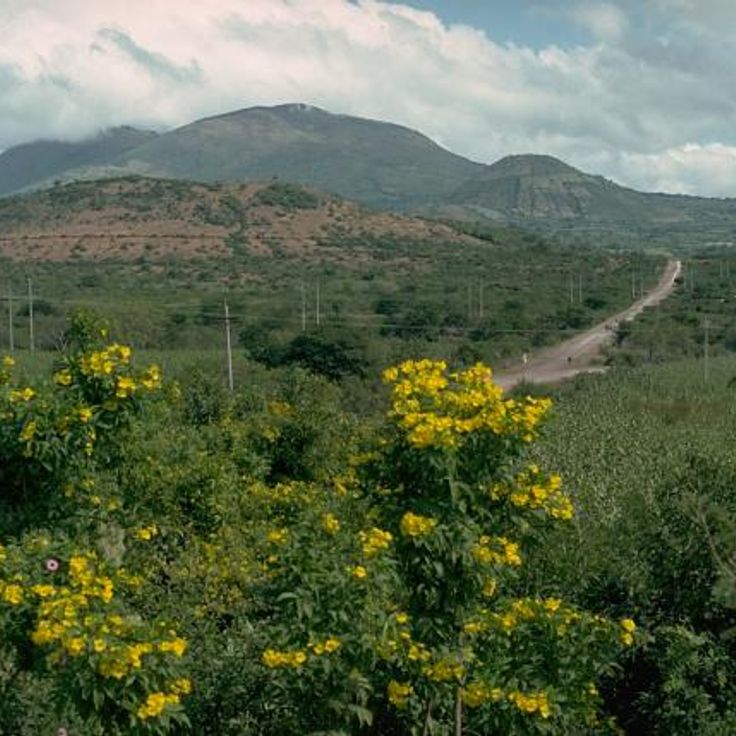
This volcano rises in the Chiquimula region and holds a crater lake at 1650 meters elevation (5400 feet). Pine forests cover the slopes while open grasslands mark the upper reaches. The hike to the summit passes through different vegetation zones, and the lake inside the crater shows changing colors depending on the time of day and weather. Photographers find subjects ranging from tropical vegetation in the lowlands to cooler elevations with views across the surrounding Guatemalan landscape.
This cave system stretches for about 14 miles (22 kilometers) and is crossed by underground rivers. The walls of Candelaria Caves display white and orange mineral deposits. For photographers, the formations and the play of light and shadow inside the chambers offer an exceptional subject in the highlands of Guatemala.
The Agua Volcano rises 3,760 meters (12,336 feet) above Antigua Guatemala and forms one of the recognizable silhouettes on the horizon. Marked hiking trails pass through different forest zones that change with elevation, offering views over the colonial city and surrounding valleys. The slopes show varying vegetation, from dense tree cover in the lower sections to more open areas higher up. The climb takes several hours and is often done with local guides who know the route and conditions. From different points, you can photograph the cone-shaped summit, especially in clear weather during the morning or late afternoon.
This freshwater lake sits in a volcanic basin, surrounded by green hills. Restaurants along the shore serve local dishes while boats carry guests across the water. Fishermen cast their nets here, and visitors can enjoy views of the surrounding volcanoes. Lake Amatitlán offers quiet moments by the water and a chance to see the Guatemalan landscape from a different angle.
This cloud forest sits between two larger towns and provides a home for the quetzal, Guatemala's national bird. The trails wind through dense vegetation with ferns, mosses and many orchid species. Birdwatchers arrive early in the morning when visibility is best and the birds are active. The reserve protects one of the last remaining habitats for these feathered creatures in Central America.
This city offers Spanish colonial churches and buildings from the 16th century, cobblestone streets and a view of three volcanic peaks: Agua, Fuego and Acatenango. Antigua Guatemala shows courtyards with fountains, pastel-colored facades and ruins of old monasteries marked by earthquakes. The streets lead through shaded plazas where vendors sell local textiles and ceramics.
This volcanic lake sits at 5125 feet (1562 meters) above sea level and is framed by three volcanoes: Atitlán, Tolimán and San Pedro. Villages along the shore preserve Maya traditions, while the water shifts in shades of blue depending on the light. Fishing boats cross the lake in the morning, and steep slopes drop down to the waterline. The lake formed about 84,000 years ago from a volcanic eruption and now provides a natural backdrop for photographs of villages, textile markets and terraced fields.
This volcano delivers photographers regular active lava flows and raw landscapes with fresh rock formations. The trails cross black volcanic stone and offer views over the surrounding fields and villages. The crater sometimes shows glowing spots, and the temperature rises when approaching the eruption zones. Pacaya Volcano releases smoke and changes shape through frequent eruptions, adding a dynamic element to photography.
This national park preserves one of the largest Maya cities from the 6th century. The pyramids and temples rise above the rainforest and offer photographers wide views over the canopy. Howler monkeys and toucans live among the ruins. Morning light filters through the trees onto the stone structures and creates contrasts between nature and ancient architecture. The temple platforms allow shots of the surrounding forests and other buildings. Mist sometimes rises between the treetops and adds another dimension to photographic compositions.
This natural limestone bridge over the Cahabón River forms terraced pools filled with turquoise water. Semuc Champey sits in the jungle of Alta Verapaz and offers photographers a chance to capture the interplay between river flow and tropical vegetation. Water cascades across multiple levels and collects in calm pools while the river continues its course underneath.
This market shows daily life among Maya communities in the highlands. Vendors offer hand-woven textiles, pottery, masks and fruit beneath tarps. Women in traditional clothing bargain over prices. Copal smoke drifts between the stalls. The church of Santo Tomás stands on the west side of the square. On Thursdays and Sundays farmers arrive from surrounding villages with their goods.
This colonial arch from the 17th century once connected two convent buildings and created a covered passage for the nuns. Photographers appreciate the framed view of Agua volcano through the arch, which represents a typical scene of the town. The yellow facade and the clock on the upper part, combined with the cobblestone street and surrounding facades, form a characteristic colonial townscape of Guatemala.
This city square shows 19th century architecture with a theater, a government palace and a cathedral. Quetzaltenango sits in the highlands of Guatemala and offers photographers colonial facades, religious buildings and public spaces where daily city life unfolds. The structures around the square reflect the style favored during the republican era.
This island on Lake Petén Itzá shows houses in different colors with red roofs along narrow stone streets. The architecture and compact layout on the water create photo subjects with Guatemalan colonial aesthetics. From the shores the settlement appears as a colored ensemble above the lake, while the streets inside offer perspectives through arches and facades.
These thermal pools sit in the mountains at 7200 feet (2200 meters) elevation, surrounded by dense vegetation. Morning mists rise between the trees as warm water steams in natural basins. Fuentes Georginas gives photographers the chance to capture the combination of volcanic activity and tropical plant life that defines Guatemala's highlands.
This Pacific coast beach consists of black volcanic sand. The water at Monterrico Beach retreats far at low tide, exposing smooth, dark flats. Waves break steadily and the ocean often carries driftwood and shells ashore. Palms and low vegetation grow along the dunes, where fishermen spread their nets and boats rest between the trees.
This Maya site preserves 500 structures from the Classic period along Lake Yaxhá. Visitors walk among stone pyramids, open plazas and temples. The grounds extend through tropical forest, and several structures provide views over the water and treetops. Yaxhá lies away from the main routes, allowing for quiet exploration without crowds. Photography in Guatemala often combines archaeology with nature, and these ruins offer both elements. Birds call between the stones, and light filters down through the canopy overhead.
This church dates from the 18th century and shows baroque architecture with yellow and white exterior walls typical of Antigua. The facade carries columns, stucco work and religious motifs that represent Spanish colonial art in Guatemala. La Merced works well for photographs of church portals, shadows on the walls and details of the decoration. Morning or late afternoon light brings out the colors and textures.
This coastal town in Izabal combines Caribbean atmosphere with the culture of the Garifuna community. Livingston is only reachable by boat and shows African, indigenous and Caribbean influences in its music, dances and food. Photographers find wooden houses on stilts, fishermen laying out their nets and street scenes with marimba sounds. The presence of palm trees, colorful facades and the slow-moving Río Dulce river creates tropical subjects. Tapado, a seafood stew with coconut milk, and freshly baked coconut bread are part of daily life and often sold on the street.
This Maya archaeological site from the 15th century displays temples, plazas and ball courts set among green hills. Iximché once served as the capital of the Kaqchikel kingdom and now offers a quiet place where visitors walk among stone ruins, photograph details of ancient architecture and take in views across the highlands.
This 3976-meter (13,044-foot) volcano in the central highlands offers trails through pine forests that lead to viewpoints overlooking the active Fuego. Fuego regularly releases ash and lava, creating visible eruptions throughout the day and night. The climb takes several hours and passes through changing vegetation zones. Photographers come here to capture the eruptions at sunrise or after dark, when the glowing lava flows are most visible against the sky.
This 16th century church combines Catholic and Maya traditions in a place where smoke from incense rises over white stone stairs. The large front courtyard often fills with people lighting candles and laying flowers. Inside, silver votive offerings hang from the walls, while outside vendors spread their goods. The steps serve as an open-air prayer space where shamans perform traditional ceremonies. Photographers find scenes of religious rituals, colorful textiles, and the meeting of two belief systems.
This historical plaza in Tikal displays Maya architecture with stone pyramids and temples arranged to create specific sound distribution. The plaza sits at the heart of the ancient city and serves as a central space between several major structures. Visitors experience the proportions and interplay of the buildings, which were designed for open sight lines and ceremonial functions. Photographers find soft morning light that brings out the textures of the stone and casts shadows emphasizing the architectural details.
This national park connects waterways with tropical vegetation and the 17th century Castillo de San Felipe fortress. Rivers wind through dense forest, passing shoreline growth and limestone formations. The Spanish fort watches over the river mouth and offers views across water and jungle. Photographers find subjects in colonial architecture, forest landscapes and river scenes. The combination of historical buildings and natural surroundings creates varied compositions between water, greenery and stone. Light filters through canopy and reflects off moving currents throughout the day.
Cerro de la Cruz is a monument on a mountaintop with views over the colonial city of Antigua. From here you see the three volcanoes Agua, Fuego and Acatenango. The spot sits about 500 feet (150 meters) above the city. Visitors come in the morning or late afternoon. The view shows the cobbled streets and colored roofs of Antigua. On clear days the volcanic cones stand out against the sky. A short path leads from the edge of town up to the cross.
This fortress from 1652 was built as a Spanish military post on the Rio Dulce to protect trade routes from Caribbean pirates. The structure is made of solid stone walls and shows the military architecture of the colonial period. Seen from the water, the fort looks compact and defensive, with small openings in the thick walls. Its location on the river makes it an interesting subject for photographers drawn to historical buildings and colonial history in Guatemala.
This town on the shores of Lake Atitlán maintains the traditions of the Tz'utujil Maya. Santiago Atitlán is known for its weaving, using natural dyes and patterns passed down through families. The church at the main square combines colonial architecture with indigenous art. The market sells textiles, pottery and produce from the surrounding hills. Religious life blends Catholic celebrations with Maya ceremonies that honor local deities.
This archaeological park preserves Maya monuments from the 8th century. The site shows carved stelae and zoomorphic stones found here. The inscriptions offer insight into regional history and document events from that period. Visitors see the stonework under tropical trees. The ruins sit in a flat area where a city once stood.
This commercial port on the Caribbean coast connects Guatemala's interior to the sea through container terminals and a cruise ship facility. The fish market sells daily catches of seafood brought in by fishermen from Caribbean waters. Warehouses and cranes mark the harbor area. Small stands near the docks offer local snacks and drinks for port workers and visitors.
This active volcano attracts scientists who work from observation platforms located at about 1500 meters away. The research station at Santiaguito documents the movements of the lava dome formations, making it a location for volcano photography in Guatemala where steam clouds and occasional eruptions shape the landscape.
This volcano rises in the Chiquimula region and holds a crater lake at 1650 meters elevation (5400 feet). Pine forests cover the slopes while open grasslands mark the upper reaches. The hike to the summit passes through different vegetation zones, and the lake inside the crater shows changing colors depending on the time of day and weather. Photographers find subjects ranging from tropical vegetation in the lowlands to cooler elevations with views across the surrounding Guatemalan landscape.
This cave system stretches for about 14 miles (22 kilometers) and is crossed by underground rivers. The walls of Candelaria Caves display white and orange mineral deposits. For photographers, the formations and the play of light and shadow inside the chambers offer an exceptional subject in the highlands of Guatemala.
The Agua Volcano rises 3,760 meters (12,336 feet) above Antigua Guatemala and forms one of the recognizable silhouettes on the horizon. Marked hiking trails pass through different forest zones that change with elevation, offering views over the colonial city and surrounding valleys. The slopes show varying vegetation, from dense tree cover in the lower sections to more open areas higher up. The climb takes several hours and is often done with local guides who know the route and conditions. From different points, you can photograph the cone-shaped summit, especially in clear weather during the morning or late afternoon.
This freshwater lake sits in a volcanic basin, surrounded by green hills. Restaurants along the shore serve local dishes while boats carry guests across the water. Fishermen cast their nets here, and visitors can enjoy views of the surrounding volcanoes. Lake Amatitlán offers quiet moments by the water and a chance to see the Guatemalan landscape from a different angle.
This cloud forest sits between two larger towns and provides a home for the quetzal, Guatemala's national bird. The trails wind through dense vegetation with ferns, mosses and many orchid species. Birdwatchers arrive early in the morning when visibility is best and the birds are active. The reserve protects one of the last remaining habitats for these feathered creatures in Central America.