Castillo de San Felipe de Lara

Log in to your account

AroundUs is a community-driven map of interesting places, built by curious explorers like you. It grows with every review, story, and photo you share.
Connect to save your favorite spots, contribute locations, and create personalized routes.
By continuing, you accept our Terms and Conditions and our Privacy Policy

Castillo de San Felipe de Lara

Add to collection
Map
Suggest a change
Share

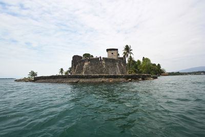
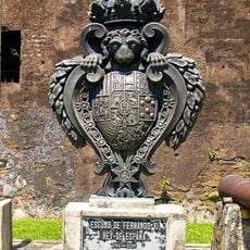
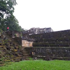
Castillo de San Felipe de Lara, Spanish colonial fort at Rio Dulce entrance, Guatemala

The stone fortress features nineteen cannons, thick defensive walls, and a central tower overlooking Lake Izabal at the mouth of Rio Dulce.

The Spanish Crown ordered construction of the fortification in 1644 to defend against pirate attacks on trading vessels navigating between Guatemala and Spain.

The fortress represents Spanish colonial military architecture in Central America, incorporating local building materials with European defensive design principles.

Visitors can access all areas of the fortress daily from 8 AM to 5 PM, with guided tours available in Spanish and English.

The fortress served three distinct functions simultaneously: military defense, customs checkpoint for maritime trade, and prison for captured pirates.

Location: Izabal Department

Inception: 1644

GPS coordinates: 15.63742,-88.99338

Latest update: May 27, 2025 13:27

Photo spots in Guatemala

Guatemala offers Maya ruins, volcanoes and colonial buildings for photographers. The landscape features lakes, rainforests and beaches. Cities display Spanish architecture and indigenous markets.

Photo locations in Guatemala

Guatemala contains several photographic subjects within its borders. Maya ruins such as Tikal, Yaxha and Quiriguá stand in the tropical forests of Petén and Izabal. Colonial architecture appears in Antigua Guatemala, where the Santa Catalina Arch and painted facades line cobblestone streets. Lake Atitlán sits between three volcanoes, with towns like Santiago Atitlán and San Marcos La Laguna offering different perspectives on the water. Active volcanoes including Pacaya and Acatenango provide opportunities to photograph lava flows and crater landscapes. The highland areas of Alta Verapaz hold Semuc Champey, a natural limestone pool, and the caves of Lanquín and Candelaria. Hot springs at Fuentes Georginas lie near Quetzaltenango in the western highlands. Chichicastenango Market documents textile trade and indigenous ceremonies. Livingston on the Rio Dulce shows Garifuna culture on the Caribbean coast, while Monterrico offers black sand beaches on the Pacific. Less visited sites like Dos Pilas, Takalik Abaj and Iximche add pre-Columbian contexts. The collection covers both well known and remote locations across Guatemala's varied geography.

Reviews

Visited this place? Tap the stars to rate it and share your experience / photos with the community! Try now! You can cancel it anytime.

« Castillo de San Felipe de Lara - Spanish colonial fort at Rio Dulce entrance, Guatemala » is provided by Around Us (aroundus.com). Images and texts are derived from Wikimedia project under a Creative Commons license. You are allowed to copy, distribute, and modify copies of this page, under the conditions set by the license, as long as this note is clearly visible.

Discover hidden gems everywhere you go!

From secret cafés to breathtaking viewpoints, skip the crowded tourist spots and find places that match your style. Our app makes it easy with voice search, smart filtering, route optimization, and insider tips from travelers worldwide. Download now for the complete mobile experience.

Around Us App Screenshot

A unique approach to discovering new places

Le Figaro

All the places worth exploring

France Info

A tailor-made excursion in just a few clicks

20 Minutes