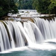
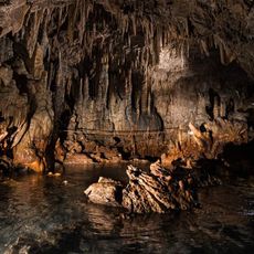
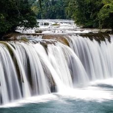
Semuc Champey, Natural limestone pools in Alta Verapaz, Guatemala
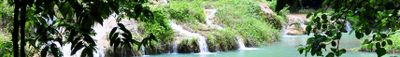
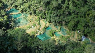
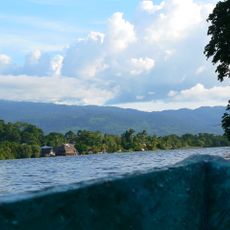
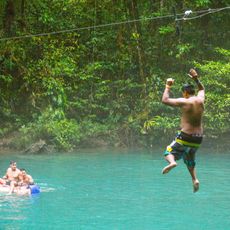
Semuc Champey is a natural limestone formation in the Alta Verapaz Department of Guatemala stretching roughly 300 meters across the Cahabón River. A sequence of tiered pools with turquoise and green water forms on its surface while the river flows through a tunnel beneath.
The Q'eqchi' Maya knew this site for centuries before outsiders documented it in the 1950s. The Guatemalan government declared the area a protected natural monument through Decree 025 in 2005 to safeguard the formation from damage.
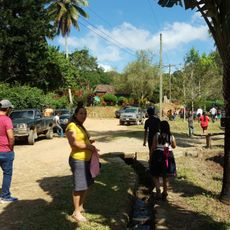
The Q'eqchi' name means where the river hides under the stones and reflects centuries of Maya knowledge about this formation. Today visitors can see how surrounding villages maintain their connection to the rainforest and use medicinal plants from the surrounding slopes.
The road to the entrance follows a winding gravel track that is often rough and most visitors hire a local driver from the town of Lanquín. A steep lookout trail offers an overview of the pools and requires roughly 45 minutes of climbing through jungle terrain.
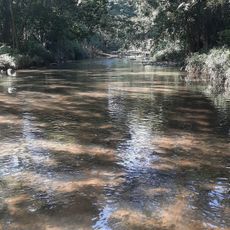
The water in the pools does not come from the main river but from smaller streams that flow down the slopes and collect on the limestone surface. The Cahabón itself is audible beneath the bridge and reemerges roughly 400 meters downstream where the water bursts foaming from the rock.
Location: Alta Verapaz Department
Inception: 2005
Part of: Cahabón River
GPS coordinates: 15.53333,-89.96111
Latest update: December 12, 2025 18:22
Waterfalls draw you in through your senses. You hear the roar of falling water, feel the mist on your skin, and watch light dance across the spray. Many of the most powerful examples are found in places that stay relatively untouched, where reaching them is half the reward. These destinations give...
Guatemala offers photographers a mix of pre-Columbian sites, volcanic landscapes, and colonial buildings. The geography ranges from highland towns to rainforests and coastal areas along the Pacific and Caribbean. Ancient Maya temples stand alongside Spanish-era churches, while indigenous markets and...
Guatemala contains several photographic subjects within its borders. Maya ruins such as Tikal, Yaxha and Quiriguá stand in the tropical forests of Petén and Izabal. Colonial architecture appears in Antigua Guatemala, where the Santa Catalina Arch and painted facades line cobblestone streets. Lake...
Quiriguá
103.1 km
Castillo de San Felipe de Lara
104.4 km
Dos Pilas
107.5 km
Biotopo del Quetzal
48 km
Reserva de la biosfera Sierra de las Minas
45.3 km
Aguateca
99.6 km
Puente de Río Dulce
104.1 km
Estadio Cementos Progreso
111 km
Cancuén
54 km
Naj Tunich
110.5 km
Ixtutz
110.9 km
Chamá
49.2 km
Museo de Paleontologia y Arqueología de Estanzuela
72.4 km
Rey Marcos Caves
36.4 km
Agua Blanca
111.7 km
Museo
102.8 km
Catarata de Urlanta
104.4 km
Calvario
59.3 km
Rio Dulce National Park
109.4 km
Casa del Quetzal y la Marimba, Museo
60.9 km
Las Conchas Natural Park
64.2 km
Calvario Poptun
106.1 km
Cuevas de B'omb'il Pek
48.5 km
La Palmilla, Usumatlan
67.7 km
Cementerio Senahú
20.2 km
Hun Nal Ye
41.7 km
Finca El Cisne
102.9 km
Puente Orellana
68.5 kmVisited this place? Tap the stars to rate it and share your experience / photos with the community! Try now! You can cancel it anytime.
Discover hidden gems everywhere you go!
From secret cafés to breathtaking viewpoints, skip the crowded tourist spots and find places that match your style. Our app makes it easy with voice search, smart filtering, route optimization, and insider tips from travelers worldwide. Download now for the complete mobile experience.
A unique approach to discovering new places❞
— Le Figaro
All the places worth exploring❞
— France Info
A tailor-made excursion in just a few clicks❞
— 20 Minutes