Chest opened
+${chestReward.xp} XP
Explorer
NOUVEAU ×${chestReward.collectible.quantity}
tapez pour fermer
Chest locked

Open chests in the app

Around Us is built for your phone — chests unlock when you walk, explore and capture nearby places.

Enable Location

We need your location to show you interesting places around you

Discover nearby places

Find interesting locations and hidden gems around you

Precise directions

Get accurate directions and distances to places

Your location is never shared with other users. It's only used when you tap the location button.

Interstate 37

Log in to your account

Start exploring — it's free

Trusted by 72,879 travelers worldwide

Continue with Google
Continue with Apple
or

We will send you a code to connect

By continuing, you accept our Terms and Conditions and our Privacy Policy

Check your inbox

We've sent a pincode in your inbox. Please enter the code below.

Interstate 37
Discussion Reviews 1 Photos
18.1k Popularity

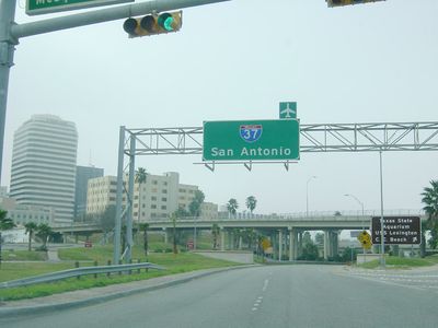
Interstate 37, Interstate Highway in Texas, United States

Interstate 37 is a highway that runs about 143 miles (230 kilometers) through southern Texas, connecting Corpus Christi with San Antonio. The road begins near the Gulf and travels north, passing through residential areas, commercial zones, and open landscapes with farms and fields.

Interstate 37 was officially established in 1959 and built during the 1960s to improve travel between Corpus Christi and San Antonio. Construction happened in several phases, with the Corpus Christi sections completed first, followed by the San Antonio area in the early 1970s.

Interstate 37 bears the names of World War II veterans who received medals for bravery. This naming honors local soldiers and their service to the nation.

Speed limits vary along the highway, reaching about 70 miles per hour (110 kilometers per hour) in open areas and slower near city centers. Expect heavy traffic during morning rush hours and near major interchanges like I-10 and I-35.

One section is named the Lucian Adams Freeway, after a soldier from Port Arthur who received numerous decorations. Another stretch carries the name of the first San Antonio native to earn the Medal of Honor in World War II.

The community of curious travelers

AroundUs brings together thousands of curated places, local tips, and hidden gems, enriched daily by 60,000 contributors worldwide.

Start exploring
Location
Location
Location
Location
Inception
October 16, 1959
GPS coordinates
28.49525,-98.14403
Latest update
February 17, 2026 00:00
Around this place
Presidio La Bahía
United States of America

Presidio La Bahía

76.3 km
Mission San Francisco de la Espada
United States of America

Mission San Francisco de la Espada

96.3 km
San Antonio Missions
United States of America

San Antonio Missions

97.7 km
Calaveras Lake
United States of America

Calaveras Lake

89.5 km
Calaveras Power Station
United States of America

Calaveras Power Station

92.1 km
Espada Acequia
United States of America

Espada Acequia

95.5 km
Lake Corpus Christi State Park
United States of America

Lake Corpus Christi State Park

54.9 km
Fannin Battleground State Historic Site
United States of America

Fannin Battleground State Historic Site

91.6 km
Zaragoza Birthplace State Historic Site
United States of America

Zaragoza Birthplace State Historic Site

76.4 km
Hangar 9, Brooks Air Force Base
United States of America

Hangar 9, Brooks Air Force Base

98.8 km
Herff-Rozelle Farm
United States of America

Herff-Rozelle Farm

96.8 km
Bee County Courthouse
United States of America

Bee County Courthouse

40.1 km
Atascosa County Courthouse
United States of America

Atascosa County Courthouse

61.4 km
NAS Chase Field-Building 1001
United States of America

NAS Chase Field-Building 1001

49 km
Mueller Bridge
United States of America

Mueller Bridge

95.7 km
Dr. L.W. and Martha E.S. Chilton House
United States of America

Dr. L.W. and Martha E.S. Chilton House

75.9 km
Live Oak County Courthouse
United States of America

Live Oak County Courthouse

18.5 km
Refugio County Courthouse
United States of America

Refugio County Courthouse

87.8 km
Live Oak County Jail
United States of America

Live Oak County Jail

6.6 km
Frederick and Sallie Lyons House
United States of America

Frederick and Sallie Lyons House

62.2 km
Wilson County Courthouse and Jail
United States of America

Wilson County Courthouse and Jail

71 km
The Greenline

The Greenline

99.2 km
Karnes County Courthouse
United States of America

Karnes County Courthouse

49.5 km
Rialto Theatre
United States of America

Rialto Theatre

40 km
Arcadia Theatre
United States of America

Arcadia Theatre

71 km
El Camino Real Visitor Center
United States of America

El Camino Real Visitor Center

76.5 km
Rialto Theater
United States of America

Rialto Theater

80.3 km
Panna Maria Historic District
United States of America

Panna Maria Historic District

54.9 km
Show the full map
Reviews
Share your experience

No review yet

Discussions
Start a discussion...

No discussion yet

« Interstate 37 - Interstate Highway in Texas, United States » is provided by Around Us (aroundus.com). Images and texts are derived from Wikimedia project under a Creative Commons license. You are allowed to copy, distribute, and modify copies of this page, under the conditions set by the license, as long as this note is clearly visible.

Discover hidden gems everywhere you go!

From secret cafés to breathtaking viewpoints, skip the crowded tourist spots and find places that match your style. Our app makes it easy with voice search, smart filtering, route optimization, and insider tips from travelers worldwide. Download now for the complete mobile experience.

Around Us App Screenshot

A unique approach to discovering new places

Le Figaro

All the places worth exploring

France Info

A tailor-made excursion in just a few clicks

20 Minutes

Around Us
Travel Guide & Maps
Download

Send to your phone

QR Code
1

Open the camera app on your mobile.

2

Point at the QR code with your camera. A notification will appear.

3

Tap the notification to open the link.