Enable Location

We need your location to show you interesting places around you

Discover nearby places

Find interesting locations and hidden gems around you

Precise directions

Get accurate directions and distances to places

Your location is never shared with other users. It's only used when you tap the location button.

Log in to your account

Start exploring — it's free

Trusted by 61,815 travelers worldwide

Continue with Google
Continue with Apple
or

We will send you a code to connect

By continuing, you accept our Terms and Conditions and our Privacy Policy

Check your inbox

We've sent a pincode in your inbox. Please enter the code below.

U.S. 61 Bonnet Carré Spillway Bridge

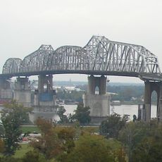
U.S. 61 Bonnet Carré Spillway Bridge, Concrete trestle bridge in St. Charles Parish, Louisiana, United States.

Description

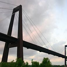
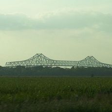
The U.S. 61 Bonnet Carré Spillway Bridge is a concrete trestle structure crossing a flood control facility with separate lanes for eastbound and westbound traffic. The roadway is divided into two distinct spans to accommodate vehicles moving in opposite directions.

History

The original bridge structure opened in 1935 as part of U.S. Route 61 during the early development of regional highways. A second span was added in 1984 to handle rising traffic volumes between the two metropolitan areas.

Culture

The bridge links communities along the Airline Highway and serves as a key transportation route between New Orleans and Baton Rouge. For residents, crossing here is part of their everyday commute between these two cities.

Practical

The eastern span carries traffic toward New Orleans while the western span handles vehicles heading toward Baton Rouge. The separated lanes make it straightforward to navigate in the correct direction for your destination.

Did you know?

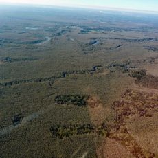
The bridge crosses a spillway engineered to divert excess Mississippi River water into Lake Pontchartrain during flood emergencies. Many drivers pass over this critical flood protection structure without realizing its role in safeguarding nearby communities.

Location
Inception
1935
Official opening
1935
GPS coordinates
30.02610,-90.42120
Latest update
December 14, 2025 16:42

AroundUs brings together thousands of curated places, local tips, and hidden gems, enriched daily by 60,000 contributors worldwide. Discover all places nearby (Louisiana).

Around this place
Whitney Plantation Historic District
United States of America

Whitney Plantation Historic District

22.2 km
Huey P. Long Bridge
United States of America

Huey P. Long Bridge

26 km
Evergreen Plantation
United States of America

Evergreen Plantation

21.1 km
Destrehan Plantation
United States of America

Destrehan Plantation

10.5 km
Hale Boggs Memorial Bridge
United States of America

Hale Boggs Memorial Bridge

10.4 km
Gramercy Bridge
United States of America

Gramercy Bridge

24.3 km
San Francisco Plantation House
United States of America

San Francisco Plantation House

18 km
The Galleria
United States of America

The Galleria

26.2 km
Ormond Plantation House
United States of America

Ormond Plantation House

8.7 km
Cajun Pride Swamp Tours
United States of America

Cajun Pride Swamp Tours

7.8 km
Homeplace Plantation House
United States of America

Homeplace Plantation House

6.3 km
Congregation Beth Israel
United States of America

Congregation Beth Israel

23.7 km
Magnolia Lane Plantation
United States of America

Magnolia Lane Plantation

26.6 km
Camp Parapet
United States of America

Camp Parapet

26.6 km
LaBranche Plantation Dependency
United States of America

LaBranche Plantation Dependency

13.2 km
Godchaux–Reserve Plantation
United States of America

Godchaux–Reserve Plantation

14.1 km
Maurepas Swamp Wildlife Management Area
United States of America

Maurepas Swamp Wildlife Management Area

16.2 km
Wildcat Stadium
United States of America

Wildcat Stadium

7.6 km
Olive Jeanette
United States of America

Olive Jeanette

26.6 km
Bayou Boeuf Elementary School
United States of America

Bayou Boeuf Elementary School

24.1 km
Emilie Plantation
United States of America

Emilie Plantation

18.3 km
Raziano House
United States of America

Raziano House

17.6 km
Our Lady of Grace Church
United States of America

Our Lady of Grace Church

14 km
Kenner Town Hall
United States of America

Kenner Town Hall

17.6 km
Dorvin House
United States of America

Dorvin House

4.2 km
San Francisco Plantation
United States of America

San Francisco Plantation

17.7 km
Hope Plantation (Louisiana)
United States of America

Hope Plantation (Louisiana)

19.2 km
Executive Tower One
United States of America

Executive Tower One

25.5 km
Show the full map
« U.S. 61 Bonnet Carré Spillway Bridge - Concrete trestle bridge in St. Charles Parish, Louisiana, United States » is provided by Around Us (aroundus.com). Images and texts are derived from Wikimedia project under a Creative Commons license. You are allowed to copy, distribute, and modify copies of this page, under the conditions set by the license, as long as this note is clearly visible.

Discover hidden gems everywhere you go!

From secret cafés to breathtaking viewpoints, skip the crowded tourist spots and find places that match your style. Our app makes it easy with voice search, smart filtering, route optimization, and insider tips from travelers worldwide. Download now for the complete mobile experience.

Around Us App Screenshot

A unique approach to discovering new places

Le Figaro

All the places worth exploring

France Info

A tailor-made excursion in just a few clicks

20 Minutes

Around Us
Travel Guide & Maps
Download

Send to your phone

QR Code
1

Open the camera app on your mobile.

2

Point at the QR code with your camera. A notification will appear.

3

Tap the notification to open the link.