Enable Location

We need your location to show you interesting places around you

Discover nearby places

Find interesting locations and hidden gems around you

Precise directions

Get accurate directions and distances to places

Your location is never shared with other users. It's only used when you tap the location button.

Gramercy Bridge

Log in to your account

Start exploring — it's free

Trusted by 61,814 travelers worldwide

Continue with Google
Continue with Apple
or

We will send you a code to connect

By continuing, you accept our Terms and Conditions and our Privacy Policy

Check your inbox

We've sent a pincode in your inbox. Please enter the code below.

Gramercy Bridge

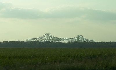
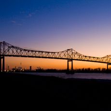
Gramercy Bridge, Cantilever bridge in Gramercy, Louisiana

Description

Gramercy Bridge is a steel cantilever structure that spans roughly 945 meters across the Mississippi River, connecting St. James Parish with St. John Parish. The roadway carries four traffic lanes along Louisiana Highway 3213 and provides approximately 50 meters of vertical clearance for river traffic passing underneath.

History

Construction became necessary after a ferry disaster in 1976 took many lives and highlighted the need for a safer crossing between the parishes. The bridge opened in 1995 and has since provided a reliable connection for the communities on both sides.

Culture

The bridge connects communities on both sides of the Mississippi and makes daily travel between the parishes much easier for local residents. It has become a central route that people from both areas rely on for work and family visits.

Practical

The bridge is most easily traversed during daylight hours when visibility is good and traffic flows predictably across all lanes. The road surface is well maintained and the crossing takes only a few minutes depending on your starting point.

Did you know?

The bridge required specialized engineering techniques to span the width and depth of the Mississippi River at this location. Its construction presented challenges beyond simple length, dealing with the river's powerful currents and changing water levels.

Location
Inception
1995
Official opening
1995
Length
945 m
Longest Span
445 m
Made from material
steel
GPS coordinates
30.04580,-90.67250
Latest update
December 9, 2025 18:40

AroundUs brings together thousands of curated places, local tips, and hidden gems, enriched daily by 60,000 contributors worldwide. Discover all places nearby (Louisiana).

Around this place
Oak Alley Plantation
United States of America

Oak Alley Plantation

11 km
Whitney Plantation Historic District
United States of America

Whitney Plantation Historic District

2.2 km
Evergreen Plantation
United States of America

Evergreen Plantation

3.7 km
Laura Plantation
United States of America

Laura Plantation

6.6 km
The Houmas
United States of America

The Houmas

27.3 km
Laurel Valley Sugar Plantation
United States of America

Laurel Valley Sugar Plantation

28.3 km
Sunshine Bridge
United States of America

Sunshine Bridge

23.8 km
Bocage Plantation
United States of America

Bocage Plantation

28.6 km
St. Joseph Plantation
United States of America

St. Joseph Plantation

10.6 km
San Francisco Plantation House
United States of America

San Francisco Plantation House

6.5 km
Ormond Plantation House
United States of America

Ormond Plantation House

29.4 km
Cajun Pride Swamp Tours
United States of America

Cajun Pride Swamp Tours

23.4 km
Homeplace Plantation House
United States of America

Homeplace Plantation House

26.9 km
Laura Plantation
United States of America

Laura Plantation

6.6 km
Godchaux–Reserve Plantation
United States of America

Godchaux–Reserve Plantation

10.5 km
Desire Plantation House
United States of America

Desire Plantation House

11.5 km
Maurepas Swamp Wildlife Management Area
United States of America

Maurepas Swamp Wildlife Management Area

18.7 km
Wildcat Stadium
United States of America

Wildcat Stadium

29.4 km
Olive Jeanette
United States of America

Olive Jeanette

2.3 km
Bayou Boeuf Elementary School
United States of America

Bayou Boeuf Elementary School

21 km
Emilie Plantation
United States of America

Emilie Plantation

6.1 km
Mather House
United States of America

Mather House

14.7 km
Our Lady of Grace Church
United States of America

Our Lady of Grace Church

11.6 km
Dorvin House
United States of America

Dorvin House

25.1 km
San Francisco Plantation
United States of America

San Francisco Plantation

6.8 km
Graugnard Farms Plantation
United States of America

Graugnard Farms Plantation

16.8 km
Hope Plantation (Louisiana)
United States of America

Hope Plantation (Louisiana)

5.1 km
Montegut Plantation
United States of America

Montegut Plantation

18.4 km
Show the full map
« Gramercy Bridge - Cantilever bridge in Gramercy, Louisiana » is provided by Around Us (aroundus.com). Images and texts are derived from Wikimedia project under a Creative Commons license. You are allowed to copy, distribute, and modify copies of this page, under the conditions set by the license, as long as this note is clearly visible.

Discover hidden gems everywhere you go!

From secret cafés to breathtaking viewpoints, skip the crowded tourist spots and find places that match your style. Our app makes it easy with voice search, smart filtering, route optimization, and insider tips from travelers worldwide. Download now for the complete mobile experience.

Around Us App Screenshot

A unique approach to discovering new places

Le Figaro

All the places worth exploring

France Info

A tailor-made excursion in just a few clicks

20 Minutes

Around Us
Travel Guide & Maps
Download

Send to your phone

QR Code
1

Open the camera app on your mobile.

2

Point at the QR code with your camera. A notification will appear.

3

Tap the notification to open the link.