Enable Location

We need your location to show you interesting places around you

Discover nearby places

Find interesting locations and hidden gems around you

Precise directions

Get accurate directions and distances to places

Your location is never shared with other users. It's only used when you tap the location button.

Sunshine Bridge

Log in to your account

Start exploring — it's free

Trusted by 61,365 travelers worldwide

Continue with Google
Continue with Apple
or

We will send you a code to connect

By continuing, you accept our Terms and Conditions and our Privacy Policy

Check your inbox

We've sent a pincode in your inbox. Please enter the code below.

Sunshine Bridge

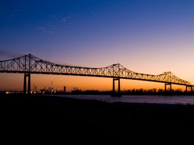
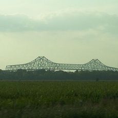
Sunshine Bridge, Cantilever road bridge in St. James Parish, Louisiana, US.

Description

Sunshine Bridge is a cantilever structure of steel that crosses the Mississippi River between St. James and Ascension parishes. The light-colored steel trusses support the roadway over the wide river channel, accommodating both passenger vehicles and commercial traffic.

History

Construction began in the early 1960s and finished in August 1964, replacing the ferry services that had previously connected the two banks. The new crossing enabled faster movement of goods and people between the parishes.

Culture

The bridge serves as a daily connection for people living and working on both sides, supporting the region's petrochemical industry and local commerce. It marks the boundary between two parishes and reflects how the river both divides and links communities together.

Practical

The bridge is free to cross and open throughout the day for all types of vehicles. Standard driving conditions apply, as the structure handles daily commuter and commercial traffic.

Did you know?

From the bridge, travelers can see sugar cane fields stretching across both sides of the river, revealing the agricultural heritage woven into the landscape. This view underscores how the crossing links farming regions and industrial zones.

Location
Inception
August 1964
Official opening
August 1964
GPS coordinates
30.09810,-90.91220
Latest update
December 7, 2025 20:41

AroundUs brings together thousands of curated places, local tips, and hidden gems, enriched daily by 60,000 contributors worldwide. Discover all places nearby (Louisiana).

Around this place
Oak Alley Plantation
United States of America

Oak Alley Plantation

16.8 km
Bayou Corne sinkhole
United States of America

Bayou Corne sinkhole

24.3 km
The Houmas
United States of America

The Houmas

5.2 km
Madewood Plantation House
United States of America

Madewood Plantation House

20.7 km
Bocage Plantation
United States of America

Bocage Plantation

5 km
Ashland Plantation
United States of America

Ashland Plantation

12 km
Gramercy Bridge
United States of America

Gramercy Bridge

23.8 km
St. Joseph Plantation
United States of America

St. Joseph Plantation

16.9 km
Carville Historic District
United States of America

Carville Historic District

23.4 km
Belle Alliance Plantation
United States of America

Belle Alliance Plantation

12.6 km
Evan Hall
United States of America

Evan Hall

12.9 km
Laura Plantation
United States of America

Laura Plantation

20.6 km
St. Emma Plantation
United States of America

St. Emma Plantation

11.5 km
River Road African American Museum
United States of America

River Road African American Museum

7.5 km
Palo Alto Plantation
United States of America

Palo Alto Plantation

11.5 km
St. Elizabeth Catholic Church
United States of America

St. Elizabeth Catholic Church

18.2 km
St. Anne Catholic Church
United States of America

St. Anne Catholic Church

21 km
Robert Penn Warren House
United States of America

Robert Penn Warren House

24.1 km
Olive Jeanette
United States of America

Olive Jeanette

21.7 km
Church of the Assumption of the Blessed Virgin Mary
United States of America

Church of the Assumption of the Blessed Virgin Mary

16.1 km
Mulberry Grove
United States of America

Mulberry Grove

15.9 km
Landry Tomb
United States of America

Landry Tomb

7.1 km
Mather House
United States of America

Mather House

14.8 km
Christ Episcopal Church and Cemetery
United States of America

Christ Episcopal Church and Cemetery

20.6 km
Decareaux House
United States of America

Decareaux House

24.8 km
LaBarre House
United States of America

LaBarre House

20.9 km
Deslattes House
United States of America

Deslattes House

24.6 km
Adam Lobell House
United States of America

Adam Lobell House

24.6 km
Show the full map
« Sunshine Bridge - Cantilever road bridge in St. James Parish, Louisiana, US » is provided by Around Us (aroundus.com). Images and texts are derived from Wikimedia project under a Creative Commons license. You are allowed to copy, distribute, and modify copies of this page, under the conditions set by the license, as long as this note is clearly visible.

Discover hidden gems everywhere you go!

From secret cafés to breathtaking viewpoints, skip the crowded tourist spots and find places that match your style. Our app makes it easy with voice search, smart filtering, route optimization, and insider tips from travelers worldwide. Download now for the complete mobile experience.

Around Us App Screenshot

A unique approach to discovering new places

Le Figaro

All the places worth exploring

France Info

A tailor-made excursion in just a few clicks

20 Minutes

Around Us
Travel Guide & Maps
Download

Send to your phone

QR Code
1

Open the camera app on your mobile.

2

Point at the QR code with your camera. A notification will appear.

3

Tap the notification to open the link.