Enable Location

We need your location to show you interesting places around you

Discover nearby places

Find interesting locations and hidden gems around you

Precise directions

Get accurate directions and distances to places

Your location is never shared with other users. It's only used when you tap the location button.

Log in to your account

Start exploring — it's free

Trusted by 63,243 travelers worldwide

Continue with Google
Continue with Apple
or

We will send you a code to connect

By continuing, you accept our Terms and Conditions and our Privacy Policy

Check your inbox

We've sent a pincode in your inbox. Please enter the code below.

CNR Bonnet Carré Spillway-Baton Rouge Bridge
Discussion Reviews Photo
1.4k Popularity

CNR Bonnet Carré Spillway-Baton Rouge Bridge, Railway bridge in St. Charles Parish, Louisiana, United States

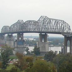
The CNR Bonnet Carré Spillway-Baton Rouge Bridge is a railway crossing that carries Canadian National Railway tracks over the Bonnet Carré Spillway. The structure was built with wooden trestle supports to span across this water management channel in Louisiana.

The bridge opened in 1936 and created a vital railway connection between Baton Rouge and New Orleans through St. Charles Parish. This link allowed freight and passengers to move across a region that was previously difficult to cross by rail.

The bridge represents a significant development in Louisiana's railway infrastructure, connecting communities and supporting regional economic growth through freight transportation.

The structure is undergoing modernization to replace wooden parts with concrete elements for future passenger train service. These upgrades prepare the railway for regular operations connecting Louisiana cities.

The bridge was specifically engineered to function alongside the spillway when it operates during flood events. This design solution allowed a permanent railway to be built across a landscape that must handle dynamic water movement.

The community of curious travelers

AroundUs brings together thousands of curated places, local tips, and hidden gems, enriched daily by 60,000 contributors worldwide.

Start exploring
Official opening
1936
GPS coordinates
30.01400,-90.43640
Latest update
December 14, 2025 16:40
Around this place
Whitney Plantation Historic District
United States of America

Whitney Plantation Historic District

20.8 km
Huey P. Long Bridge
United States of America

Huey P. Long Bridge

26.9 km
Evergreen Plantation
United States of America

Evergreen Plantation

19.7 km
Destrehan Plantation
United States of America

Destrehan Plantation

10.3 km
NOLA Motorsports Park
United States of America

NOLA Motorsports Park

27.2 km
Hale Boggs Memorial Bridge
United States of America

Hale Boggs Memorial Bridge

10 km
Gramercy Bridge
United States of America

Gramercy Bridge

23 km
San Francisco Plantation House
United States of America

San Francisco Plantation House

16.8 km
The Galleria
United States of America

The Galleria

27.5 km
Ormond Plantation House
United States of America

Ormond Plantation House

8.2 km
Homeplace Plantation House
United States of America

Homeplace Plantation House

5.5 km
Congregation Beth Israel
United States of America

Congregation Beth Israel

25.1 km
LaBranche Plantation Dependency
United States of America

LaBranche Plantation Dependency

13.6 km
Godchaux–Reserve Plantation
United States of America

Godchaux–Reserve Plantation

13.1 km
Desire Plantation House
United States of America

Desire Plantation House

25.9 km
Maurepas Swamp Wildlife Management Area
United States of America

Maurepas Swamp Wildlife Management Area

16.6 km
Wildcat Stadium
United States of America

Wildcat Stadium

7.5 km
Olive Jeanette
United States of America

Olive Jeanette

25.2 km
Bayou Boeuf Elementary School
United States of America

Bayou Boeuf Elementary School

22.1 km
Emilie Plantation
United States of America

Emilie Plantation

17.1 km
Raziano House
United States of America

Raziano House

18.7 km
Our Lady of Grace Church
United States of America

Our Lady of Grace Church

13.3 km
Colonial Bowling Center
United States of America

Colonial Bowling Center

24.7 km
Kenner Town Hall
United States of America

Kenner Town Hall

18.7 km
Dorvin House
United States of America

Dorvin House

3.2 km
San Francisco Plantation
United States of America

San Francisco Plantation

16.5 km
Hope Plantation (Louisiana)
United States of America

Hope Plantation (Louisiana)

17.9 km
Executive Tower One
United States of America

Executive Tower One

26.9 km
Show the full map
Reviews
Share your experience

No review yet

Discussions
Start a discussion...

No discussion yet

« CNR Bonnet Carré Spillway-Baton Rouge Bridge - Railway bridge in St. Charles Parish, Louisiana, United States » is provided by Around Us (aroundus.com). Images and texts are derived from Wikimedia project under a Creative Commons license. You are allowed to copy, distribute, and modify copies of this page, under the conditions set by the license, as long as this note is clearly visible.

Discover hidden gems everywhere you go!

From secret cafés to breathtaking viewpoints, skip the crowded tourist spots and find places that match your style. Our app makes it easy with voice search, smart filtering, route optimization, and insider tips from travelers worldwide. Download now for the complete mobile experience.

Around Us App Screenshot

A unique approach to discovering new places

Le Figaro

All the places worth exploring

France Info

A tailor-made excursion in just a few clicks

20 Minutes

Around Us
Travel Guide & Maps
Download

Send to your phone

QR Code
1

Open the camera app on your mobile.

2

Point at the QR code with your camera. A notification will appear.

3

Tap the notification to open the link.