Enable Location

We need your location to show you interesting places around you

Discover nearby places

Find interesting locations and hidden gems around you

Precise directions

Get accurate directions and distances to places

Your location is never shared with other users. It's only used when you tap the location button.

Israel LaFleur Bridge

Log in to your account

Start exploring — it's free

Trusted by 62,500 travelers worldwide

Continue with Google
Continue with Apple
or

We will send you a code to connect

By continuing, you accept our Terms and Conditions and our Privacy Policy

Check your inbox

We've sent a pincode in your inbox. Please enter the code below.

Israel LaFleur Bridge

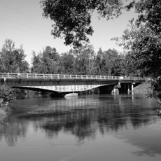
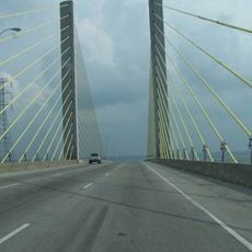
Israel LaFleur Bridge, Road bridge in Lake Charles, United States

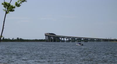
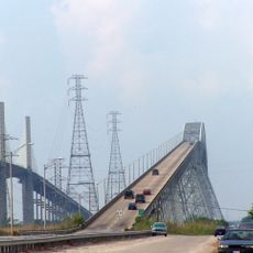
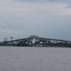
The Israel LaFleur Bridge is a concrete road bridge that spans the Calcasieu Ship Channel and Prien Lake to connect both sides of Lake Charles via Interstate 210. The structure carries heavy daily traffic between the northern and southern parts of the city.

The bridge was completed in 1962 and represented a significant advancement in Louisiana's transportation network. It established a critical link between Interstate 10 and the southern areas of Lake Charles.

The bridge serves as a central element in Lake Charles' infrastructure, facilitating daily connections between communities and supporting regional economic activities.

The bridge is accessed via Interstate 210, which offers direct routes to multiple destinations throughout Lake Charles with no toll charges. Vehicles can use the bridge at any time without special restrictions or fees.

Standing at 140 feet tall and stretching 8,500 feet long, this concrete structure maintains a 96% structural rating after six decades of service.

The community of curious travelers

AroundUs brings together thousands of curated places, local tips, and hidden gems, enriched daily by 60,000 contributors worldwide.

Start exploring
Location
Inception
1962
Official opening
1962
GPS coordinates
30.20170,-93.28040
Latest update
December 11, 2025 18:01
Around this place
Rainbow Bridge
United States of America

Rainbow Bridge

62.1 km
Calcasieu River Bridge
United States of America

Calcasieu River Bridge

5.2 km
Capital One Tower
United States of America

Capital One Tower

6.7 km
Cowboy Stadium
United States of America

Cowboy Stadium

7.5 km
Sam Houston Jones State Park
United States of America

Sam Houston Jones State Park

11.4 km
Sabine National Wildlife Refuge
United States of America

Sabine National Wildlife Refuge

41.5 km
W. H. Stark House
United States of America

W. H. Stark House

45.4 km
Cameron Prairie National Wildlife Refuge
United States of America

Cameron Prairie National Wildlife Refuge

39.6 km
Lacassine National Wildlife Refuge
United States of America

Lacassine National Wildlife Refuge

48.2 km
Cathedral of the Immaculate Conception
United States of America

Cathedral of the Immaculate Conception

6.7 km
Stark Museum of Art
United States of America

Stark Museum of Art

45.5 km
Gerstner Field
United States of America

Gerstner Field

21.5 km

Deweyville Swing Bridge
United States of America

Deweyville Swing Bridge

46 km
All Saints Episcopal Church
United States of America

All Saints Episcopal Church

31.3 km
Hebert House
United States of America

Hebert House

52.9 km
Orange County Courthouse
United States of America

Orange County Courthouse

45.6 km
Jennings Carnegie Public Library
United States of America

Jennings Carnegie Public Library

59.4 km
Calkins-Orvis House
United States of America

Calkins-Orvis House

44.1 km
Strand Theatre
United States of America

Strand Theatre

59.9 km
More Mileage Gas Station
United States of America

More Mileage Gas Station

60 km
S.A. Pennington House
United States of America

S.A. Pennington House

64.1 km
Angelus
United States of America

Angelus

60.3 km
Holly Beach
United States of America

Holly Beach

51.1 km
The Children's Museum of Southwest Louisiana
United States of America

The Children's Museum of Southwest Louisiana

6.4 km
DeQuincy Railroad Museum
United States of America

DeQuincy Railroad Museum

31.6 km
Veterans Memorial Bridge
United States of America

Veterans Memorial Bridge

61.9 km
Interstate 10 Bridge
United States of America

Interstate 10 Bridge

41.3 km
Show the full map
« Israel LaFleur Bridge - Road bridge in Lake Charles, United States » is provided by Around Us (aroundus.com). Images and texts are derived from Wikimedia project under a Creative Commons license. You are allowed to copy, distribute, and modify copies of this page, under the conditions set by the license, as long as this note is clearly visible.

Discover hidden gems everywhere you go!

From secret cafés to breathtaking viewpoints, skip the crowded tourist spots and find places that match your style. Our app makes it easy with voice search, smart filtering, route optimization, and insider tips from travelers worldwide. Download now for the complete mobile experience.

Around Us App Screenshot

A unique approach to discovering new places

Le Figaro

All the places worth exploring

France Info

A tailor-made excursion in just a few clicks

20 Minutes

Around Us
Travel Guide & Maps
Download

Send to your phone

QR Code
1

Open the camera app on your mobile.

2

Point at the QR code with your camera. A notification will appear.

3

Tap the notification to open the link.