Enable Location

We need your location to show you interesting places around you

Discover nearby places

Find interesting locations and hidden gems around you

Precise directions

Get accurate directions and distances to places

Your location is never shared with other users. It's only used when you tap the location button.

Tristram Bethea House

Log in to your account

Start exploring — it's free

Trusted by 62,494 travelers worldwide

Continue with Google
Continue with Apple
or

We will send you a code to connect

By continuing, you accept our Terms and Conditions and our Privacy Policy

Check your inbox

We've sent a pincode in your inbox. Please enter the code below.

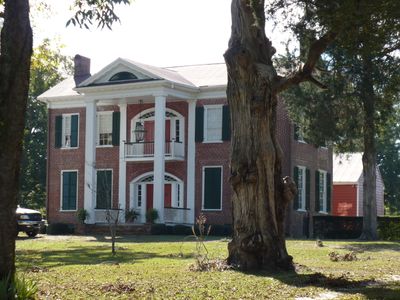
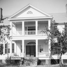
Tristram Bethea House, human settlement in Alabama, United States of America

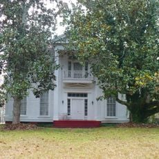
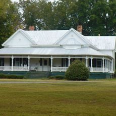
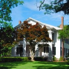
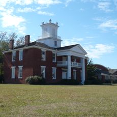
The Tristram Bethea House is a large two-story brick structure built before the Civil War in Canton Bend, Alabama. It displays elements of Federal and Greek Revival architecture with detailed woodwork around openings and features a compact interior layout with one main room per floor plus a separate frame addition at the rear.

The house was built around 1844 by Tristram Bethea, who had moved from South Carolina and chose brick construction as a sign of lasting prosperity. Ownership passed through local families until the 1940s, when the structure declined, remaining vacant for decades until new owners acquired and carefully restored it in 1987.

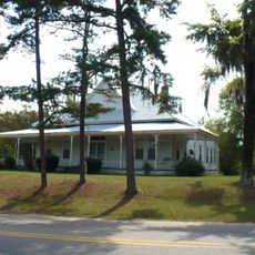
The house is also known as 'Pleasant Ridge,' reflecting the agricultural landscape that once defined the area. The name hints at the peaceful setting that characterized plantations of this era and the land's role in the region's history.

The house sits beside the road in Canton Bend and can be viewed from the street, though public access to the interior is not available as it remains a private residence. Daytime visits with good light offer the best view of the brick details and woodwork from the road.

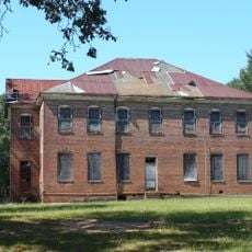
A government survey photographed the house in detail in 1937, documenting its appearance long before the recent restoration work began. These archival images reveal the structure's decline over decades and provide a rare glimpse into how deteriorated it had become before revival.

The community of curious travelers

AroundUs brings together thousands of curated places, local tips, and hidden gems, enriched daily by 60,000 contributors worldwide.

Start exploring
Location
Architectural style
Greek Revival architecture
GPS coordinates
32.05306,-87.35028
Latest update
February 9, 2026 08:18
Around this place
Cahaba
United States of America

Cahaba

37.6 km
Adams Grove Presbyterian Church
United States of America

Adams Grove Presbyterian Church

38.7 km
Millers Ferry Lock and Dam
United States of America

Millers Ferry Lock and Dam

7.1 km
Snow Hill Normal and Industrial Institute
United States of America

Snow Hill Normal and Industrial Institute

30.2 km
Hawthorne House
United States of America

Hawthorne House

39.2 km
St. Luke's Episcopal Church
United States of America

St. Luke's Episcopal Church

37.6 km
Dry Fork Plantation
United States of America

Dry Fork Plantation

16.9 km
William "Bill" Dannelly Reservoir
United States of America

William "Bill" Dannelly Reservoir

8.7 km
William Poole House
United States of America

William Poole House

43.1 km
New Hope Baptist Church
United States of America

New Hope Baptist Church

37.1 km
Street Manual Training School
United States of America

Street Manual Training School

28.2 km
William King Beck House
United States of America

William King Beck House

1.7 km
C. S. Golden House
United States of America

C. S. Golden House

35.6 km
Pleasant Hill Presbyterian Church
United States of America

Pleasant Hill Presbyterian Church

43.5 km
Oak Hill Historic District
United States of America

Oak Hill Historic District

29.2 km
Ackerville Baptist Church of Christ
United States of America

Ackerville Baptist Church of Christ

26.7 km
Airmount Grave Shelter
United States of America

Airmount Grave Shelter

31.5 km
Pine Apple Historic District
United States of America

Pine Apple Historic District

39.7 km
Carlowville Historic District
United States of America

Carlowville Historic District

30.6 km
Furman Historic District
United States of America

Furman Historic District

36.6 km
J. Bruce Hain House
United States of America

J. Bruce Hain House

43.1 km
Thomaston Colored Institute
United States of America

Thomaston Colored Institute

36 km
Wilcox Female Institute
United States of America

Wilcox Female Institute

8.4 km
Prairie Mission
United States of America

Prairie Mission

12.3 km
Wilcox County Courthouse Historic District
United States of America

Wilcox County Courthouse Historic District

9 km
Thomasville Historic District
United States of America

Thomasville Historic District

39.7 km
Patrick Farrish House
United States of America

Patrick Farrish House

34.9 km
Thomaston Central Historic District
United States of America

Thomaston Central Historic District

35.4 km
Show the full map
« Tristram Bethea House - human settlement in Alabama, United States of America » is provided by Around Us (aroundus.com). Images and texts are derived from Wikimedia project under a Creative Commons license. You are allowed to copy, distribute, and modify copies of this page, under the conditions set by the license, as long as this note is clearly visible.

Discover hidden gems everywhere you go!

From secret cafés to breathtaking viewpoints, skip the crowded tourist spots and find places that match your style. Our app makes it easy with voice search, smart filtering, route optimization, and insider tips from travelers worldwide. Download now for the complete mobile experience.

Around Us App Screenshot

A unique approach to discovering new places

Le Figaro

All the places worth exploring

France Info

A tailor-made excursion in just a few clicks

20 Minutes

Around Us
Travel Guide & Maps
Download

Send to your phone

QR Code
1

Open the camera app on your mobile.

2

Point at the QR code with your camera. A notification will appear.

3

Tap the notification to open the link.