Enable Location

We need your location to show you interesting places around you

Discover nearby places

Find interesting locations and hidden gems around you

Precise directions

Get accurate directions and distances to places

Your location is never shared with other users. It's only used when you tap the location button.

Log in to your account

Start exploring — it's free

Trusted by 68,758 travelers worldwide

Continue with Google
Continue with Apple
or

We will send you a code to connect

By continuing, you accept our Terms and Conditions and our Privacy Policy

Check your inbox

We've sent a pincode in your inbox. Please enter the code below.

Amory Lock
Discussion Reviews Photo
1.3k Popularity

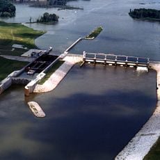
Amory Lock, Lock and dam system on Tennessee-Tombigbee Waterway in Mississippi, United States

Amory Lock is a lock and dam system on the Tennessee-Tombigbee Waterway that allows vessels to navigate between different water levels at mile 371. The structure raises and lowers ships between two water surfaces to allow continuous passage through the waterway.

The lock was built as part of a larger project to improve navigation on the Tennessee-Tombigbee Waterway. The structure altered the landscape by creating a large reservoir north of the dam.

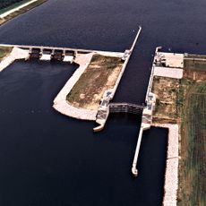
The lock serves as a meeting point where boat operators from different backgrounds follow shared protocols and communicate via radio. It shapes daily life for everyone traveling this waterway.

Visitors can watch the lock from shore or approach it by boat and wait for clearance to pass through. It is helpful to know the local approach rules and expect waits, as operations follow a set schedule.

The lock uses a less common marine radio channel for communication, which sets it apart from other locks in the region. Boat operators must tune to this specific channel to communicate with staff.

The community of curious travelers

AroundUs brings together thousands of curated places, local tips, and hidden gems, enriched daily by 60,000 contributors worldwide.

Start exploring
Location
GPS coordinates
34.01110,-88.48920
Latest update
December 14, 2025 18:13
Around this place
Elvis Presley Birthplace
United States of America

Elvis Presley Birthplace

32.8 km
Tupelo National Battlefield
United States of America

Tupelo National Battlefield

35.5 km
Bynum Mound and Village Site
United States of America

Bynum Mound and Village Site

44 km
Tupelo Buffalo Park and Zoo
United States of America

Tupelo Buffalo Park and Zoo

40.5 km
James Greer Bankhead House
United States of America

James Greer Bankhead House

35.9 km
Trace State Park
United States of America

Trace State Park

46.8 km
Tombigbee State Park
United States of America

Tombigbee State Park

27.9 km
Aberdeen Lock and Dam
United States of America

Aberdeen Lock and Dam

20.3 km
Payne Field
United States of America

Payne Field

40.7 km
Reuben Davis House
United States of America

Reuben Davis House

21.6 km
Owl Creek Mounds
United States of America

Owl Creek Mounds

40.4 km
Fairpark
United States of America

Fairpark

33.6 km
Fulton Lock
United States of America

Fulton Lock

28.1 km
West Commerce Street Historic District
United States of America

West Commerce Street Historic District

21.6 km
Aberdeen City Hall
United States of America

Aberdeen City Hall

21.3 km
Cox-Uithoven House
United States of America

Cox-Uithoven House

45.7 km
North Broadway Historic District
United States of America

North Broadway Historic District

34.2 km
First Methodist Church
United States of America

First Methodist Church

34 km
John Holliday House
United States of America

John Holliday House

22 km
Amory's Tribute to the Heroes of 1861–1865
United States of America

Amory's Tribute to the Heroes of 1861–1865

2.9 km
Old Homestead
United States of America

Old Homestead

21.5 km
Stewart-Anderson House
United States of America

Stewart-Anderson House

34.6 km
Tammy Wynette Legacy Center
United States of America

Tammy Wynette Legacy Center

32.5 km
Aberdeen Downtown Historic District
United States of America

Aberdeen Downtown Historic District

21.3 km
Amory Railway Bridge
United States of America

Amory Railway Bridge

2 km
Downtown Tupelo Historic District
United States of America

Downtown Tupelo Historic District

34 km
United States of America

Old Town Overlook

39.1 km
United States of America

Black Belt Overlook

34.2 km
Show the full map
Reviews
Share your experience

No review yet

Discussions
Start a discussion...

No discussion yet

« Amory Lock - Lock and dam system on Tennessee-Tombigbee Waterway in Mississippi, United States » is provided by Around Us (aroundus.com). Images and texts are derived from Wikimedia project under a Creative Commons license. You are allowed to copy, distribute, and modify copies of this page, under the conditions set by the license, as long as this note is clearly visible.

Discover hidden gems everywhere you go!

From secret cafés to breathtaking viewpoints, skip the crowded tourist spots and find places that match your style. Our app makes it easy with voice search, smart filtering, route optimization, and insider tips from travelers worldwide. Download now for the complete mobile experience.

Around Us App Screenshot

A unique approach to discovering new places

Le Figaro

All the places worth exploring

France Info

A tailor-made excursion in just a few clicks

20 Minutes

Around Us
Travel Guide & Maps
Download

Send to your phone

QR Code
1

Open the camera app on your mobile.

2

Point at the QR code with your camera. A notification will appear.

3

Tap the notification to open the link.