Chest opened
+${chestReward.xp} XP
Explorer
NOUVEAU ×${chestReward.collectible.quantity}
tapez pour fermer
Chest locked

Open chests in the app

Around Us is built for your phone — chests unlock when you walk, explore and capture nearby places.

Enable Location

We need your location to show you interesting places around you

Discover nearby places

Find interesting locations and hidden gems around you

Precise directions

Get accurate directions and distances to places

Your location is never shared with other users. It's only used when you tap the location button.

Log in to your account

Start exploring — it's free

Trusted by 72,877 travelers worldwide

Continue with Google
Continue with Apple
or

We will send you a code to connect

By continuing, you accept our Terms and Conditions and our Privacy Policy

Check your inbox

We've sent a pincode in your inbox. Please enter the code below.

Brock Gap
Discussion Reviews Photo
2k Popularity

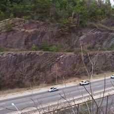
Brock Gap, Railroad pass through Shades Mountain in Hoover, Alabama.

Brock Gap is a railroad cut through Shades Mountain near Hoover that reaches a depth of about 75 feet (23 meters). The cut was carved directly through solid limestone rock, with the railroad tracks sitting at approximately 518 feet (158 meters) above sea level.

The location was selected in 1858 by John T. Milner for the South & North Alabama Railroad to enable northbound rail service. Construction work was interrupted by the American Civil War and was not completed until 1871.

The name Brock Gap comes from the family who owned land in this area. Visitors can see how the railway continues to divide the landscape and remains an important part of local infrastructure today.

The cut remains actively used by the CSX Lineville Subdivision, connecting Birmingham with Atlanta and extending toward Florida. The best viewing spot is from the adjacent road, as the railroad property is not publicly accessible.

The limestone excavation during the cut's creation required extensive use of nitroglycerin, which was an extreme challenge at that time. Massive stone blocks created by these blasts remain visible around the railway line today.

The community of curious travelers

AroundUs brings together thousands of curated places, local tips, and hidden gems, enriched daily by 60,000 contributors worldwide.

Start exploring
Location
GPS coordinates
33.33670,-86.87080
Latest update
December 14, 2025 11:06
Around this place
Vulcan statue
United States of America

Vulcan statue

18.6 km
Hoover Metropolitan Stadium
United States of America

Hoover Metropolitan Stadium

2 km
Oak Mountain State Park
United States of America

Oak Mountain State Park

9.4 km
Birmingham Zoo
United States of America

Birmingham Zoo

18.8 km
Arlington Antebellum Home & Gardens
United States of America

Arlington Antebellum Home & Gardens

18.4 km
Seibert Stadium
United States of America

Seibert Stadium

15.7 km
Rampage
United States of America

Rampage

12.6 km
Zoomerang
United States of America

Zoomerang

12.6 km
Birmingham Botanical Gardens
United States of America

Birmingham Botanical Gardens

19.4 km
Watercress Darter National Wildlife Refuge
United States of America

Watercress Darter National Wildlife Refuge

9.5 km
Alys Robinson Stephens Performing Arts Center
United States of America

Alys Robinson Stephens Performing Arts Center

18.8 km
Aldridge Botanical Gardens
United States of America

Aldridge Botanical Gardens

9.2 km
Red Mountain Expressway Cut
United States of America

Red Mountain Expressway Cut

19.3 km
Bessemer Hall of History
United States of America

Bessemer Hall of History

10.3 km
Canaan Baptist Church
United States of America

Canaan Baptist Church

11.3 km
Paul William Dunbar High School
United States of America

Paul William Dunbar High School

11.2 km
St. Andrew's Episcopal Church
United States of America

St. Andrew's Episcopal Church

18.6 km
Flintridge Building
United States of America

Flintridge Building

16.2 km
Rosedale Historic District
United States of America

Rosedale Historic District

18 km
West Campus Field
United States of America

West Campus Field

18.7 km
Sadler House
United States of America

Sadler House

13.5 km
Arlington Park
United States of America

Arlington Park

18.4 km
Second Presbyterian Church
United States of America

Second Presbyterian Church

18.8 km
Bernice L. Wright Lustron House
United States of America

Bernice L. Wright Lustron House

19.2 km
John D. and Katherine Gleissner Lustron House
United States of America

John D. and Katherine Gleissner Lustron House

19.2 km
Agee House
United States of America

Agee House

19.2 km
Belview Heights Historic District
United States of America

Belview Heights Historic District

17.2 km
Miles Memorial College Historic District
United States of America

Miles Memorial College Historic District

16.5 km
Show the full map
Reviews
Share your experience

No review yet

Discussions
Start a discussion...

No discussion yet

« Brock Gap - Railroad pass through Shades Mountain in Hoover, Alabama » is provided by Around Us (aroundus.com). Images and texts are derived from Wikimedia project under a Creative Commons license. You are allowed to copy, distribute, and modify copies of this page, under the conditions set by the license, as long as this note is clearly visible.

Discover hidden gems everywhere you go!

From secret cafés to breathtaking viewpoints, skip the crowded tourist spots and find places that match your style. Our app makes it easy with voice search, smart filtering, route optimization, and insider tips from travelers worldwide. Download now for the complete mobile experience.

Around Us App Screenshot

A unique approach to discovering new places

Le Figaro

All the places worth exploring

France Info

A tailor-made excursion in just a few clicks

20 Minutes

Around Us
Travel Guide & Maps
Download

Send to your phone

QR Code
1

Open the camera app on your mobile.

2

Point at the QR code with your camera. A notification will appear.

3

Tap the notification to open the link.