Chest opened
+${chestReward.xp} XP
Explorer
NOUVEAU ×${chestReward.collectible.quantity}
tapez pour fermer
Chest locked

Open chests in the app

Around Us is built for your phone — chests unlock when you walk, explore and capture nearby places.

Enable Location

We need your location to show you interesting places around you

Discover nearby places

Find interesting locations and hidden gems around you

Precise directions

Get accurate directions and distances to places

Your location is never shared with other users. It's only used when you tap the location button.

Ironwood Forest National Monument

Log in to your account

Start exploring — it's free

Trusted by 73,052 travelers worldwide

Continue with Google
Continue with Apple
or

We will send you a code to connect

By continuing, you accept our Terms and Conditions and our Privacy Policy

Check your inbox

We've sent a pincode in your inbox. Please enter the code below.

Ironwood Forest National Monument
Discussion Reviews 1 Photos
11k Popularity

Ironwood Forest National Monument, National Monument in southern Arizona, United States

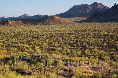
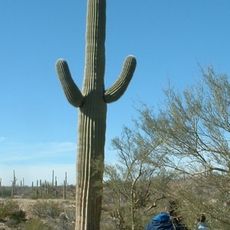
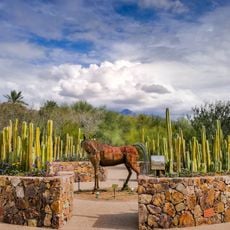
Ironwood Forest National Monument is a protected area encompassing mountain ranges and valleys with varying elevations and dense stands of ironwood trees native to the Sonoran Desert. The landscape features different terrain types and diverse plant communities across its vast expanse.

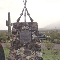
The area was used by the Hohokam for turquoise mining before silver and copper mining operations began around 1850 and transformed the landscape. These mining activities left lasting marks on the region.

The area holds archaeological sites linked to the Hohokam people and Spanish colonial presence, showing how communities lived and worked across different periods in this desert landscape.

Accessing this monument requires high-clearance or four-wheel-drive vehicles due to rough road conditions throughout the protected area. Plan your visit during cooler months to avoid the intense desert heat.

The ironwood trees here live for hundreds of years and provide shelter for young plants in the harsh desert environment. These long-lived trees are essential to the local ecosystem.

The community of curious travelers

AroundUs brings together thousands of curated places, local tips, and hidden gems, enriched daily by 60,000 contributors worldwide.

Start exploring
Location
Inception
2000
GPS coordinates
32.45896,-111.56679
Latest update
December 8, 2025 13:43
Around this place
Kitt Peak National Observatory
United States of America

Kitt Peak National Observatory

55.8 km
Picacho Peak State Park
United States of America

Picacho Peak State Park

23.8 km
Arizona-Sonora Desert Museum
United States of America

Arizona-Sonora Desert Museum

44.5 km
Dark Energy Spectroscopic Instrument
United States of America

Dark Energy Spectroscopic Instrument

55.8 km
Kitt Peak
United States of America

Kitt Peak

55.1 km
McMath–Pierce Solar Telescope
United States of America

McMath–Pierce Solar Telescope

55.8 km
Corona Satellite Calibration Targets
United States of America

Corona Satellite Calibration Targets

39 km
Nicholas U. Mayall Telescope
United States of America

Nicholas U. Mayall Telescope

55.3 km
WIYN Telescope
United States of America

WIYN Telescope

55.9 km
ARO 12m Radio Telescope
United States of America

ARO 12m Radio Telescope

56.5 km
Tohono Chul | Gardens, Galleries, and Bistro
United States of America

Tohono Chul | Gardens, Galleries, and Bistro

56.6 km
Bok Telescope
United States of America

Bok Telescope

55.3 km
United States of America

Gu Achi Peak

31.7 km
Casa Grande Stone Church
United States of America

Casa Grande Stone Church

50 km
First Baptist Church
United States of America

First Baptist Church

50 km
Casa Grande Woman's Club Building
United States of America

Casa Grande Woman's Club Building

50 km
Saint Anthony's Church
United States of America

Saint Anthony's Church

49.5 km
White House
United States of America

White House

50 km
Valley National Bank
United States of America

Valley National Bank

49 km
Cruz Trading Post
United States of America

Cruz Trading Post

49.7 km
Building at 400 East Third Street
United States of America

Building at 400 East Third Street

49.6 km
Henry and Anna Kochsmeier House
United States of America

Henry and Anna Kochsmeier House

49.8 km
Walter Wilbur House
United States of America

Walter Wilbur House

49.8 km
Casa Grande Hospital
United States of America

Casa Grande Hospital

49.7 km
The Domes of Casa Grande
United States of America

The Domes of Casa Grande

43.9 km
Paramount Theatre
United States of America

Paramount Theatre

49.8 km
Casa Grande City Hall
United States of America

Casa Grande City Hall

49.8 km
Red Hills Visitor Center
United States of America

Red Hills Visitor Center

41.6 km
Show the full map
Reviews
Share your experience

No review yet

Discussions
Start a discussion...

No discussion yet

« Ironwood Forest National Monument - National Monument in southern Arizona, United States » is provided by Around Us (aroundus.com). Images and texts are derived from Wikimedia project under a Creative Commons license. You are allowed to copy, distribute, and modify copies of this page, under the conditions set by the license, as long as this note is clearly visible.

Discover hidden gems everywhere you go!

From secret cafés to breathtaking viewpoints, skip the crowded tourist spots and find places that match your style. Our app makes it easy with voice search, smart filtering, route optimization, and insider tips from travelers worldwide. Download now for the complete mobile experience.

Around Us App Screenshot

A unique approach to discovering new places

Le Figaro

All the places worth exploring

France Info

A tailor-made excursion in just a few clicks

20 Minutes

Around Us
Travel Guide & Maps
Download

Send to your phone

QR Code
1

Open the camera app on your mobile.

2

Point at the QR code with your camera. A notification will appear.

3

Tap the notification to open the link.