Chest opened
+${chestReward.xp} XP
Explorer
NOUVEAU ×${chestReward.collectible.quantity}
tapez pour fermer
Chest locked

Open chests in the app

Around Us is built for your phone — chests unlock when you walk, explore and capture nearby places.

Enable Location

We need your location to show you interesting places around you

Discover nearby places

Find interesting locations and hidden gems around you

Precise directions

Get accurate directions and distances to places

Your location is never shared with other users. It's only used when you tap the location button.

Perdido Pass

Log in to your account

Start exploring — it's free

Trusted by 72,886 travelers worldwide

Continue with Google
Continue with Apple
or

We will send you a code to connect

By continuing, you accept our Terms and Conditions and our Privacy Policy

Check your inbox

We've sent a pincode in your inbox. Please enter the code below.

Perdido Pass
Discussion Reviews 1 Photos
9.7k Popularity

Perdido Pass, Coastal waterway in Orange Beach, Alabama, US

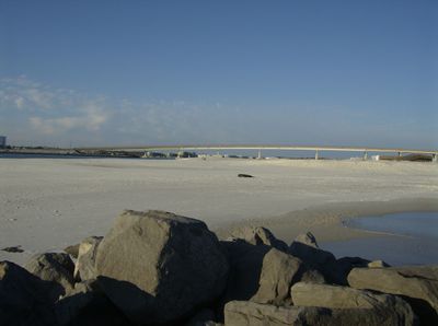
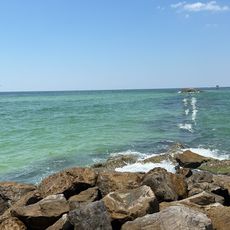
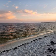
Perdido Pass is a coastal water passage in Orange Beach, Alabama, that connects Perdido Bay to the Gulf of Mexico, flanked by two rock barriers rising from white sandy shores. The channel runs between these barriers, and tidal currents shape the flow of water through it at all times.

The pass was cut in 1906 when local residents dug a new channel through Point Ornocor, and a hurricane that struck soon after widened it considerably. Those changes sealed off the original inlet and left the waterway in its present form.

The pass marks a natural boundary between Alabama Point and Florida Point, and local boaters and fishermen from both states pass through it regularly. Standing at the shore, you can watch a steady flow of vessels moving between the bay and the open gulf.

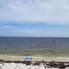
Water depth in the channel shifts with the tides and weather, so boaters should check local conditions and tide times before heading out. Visitors on foot can walk along both shores, but the ground near the rock barriers is uneven, so sturdy footwear is a good idea.

The pass drifts slowly westward because of longshore currents, with sand piling up on the eastern side while the western edge gradually wears away. Over time, this shift changes the navigation routes that boaters rely on and reshapes the banks on both sides.

The community of curious travelers

AroundUs brings together thousands of curated places, local tips, and hidden gems, enriched daily by 60,000 contributors worldwide.

Start exploring
GPS coordinates
30.27500,-87.55500
Latest update
March 3, 2026 08:19
Around this place
Fort Pickens
United States of America

Fort Pickens

26.1 km
National Naval Aviation Museum
United States of America

National Naval Aviation Museum

25.5 km
Fort Barrancas
United States of America

Fort Barrancas

26 km
Gulf State Park
United States of America

Gulf State Park

9.1 km
Gulf Shores Public Beach
United States of America

Gulf Shores Public Beach

14.8 km
Big Lagoon State Park
United States of America

Big Lagoon State Park

15.5 km
Alabama Gulf Coast Zoo
United States of America

Alabama Gulf Coast Zoo

12.5 km
Bon Secour National Wildlife Refuge
United States of America

Bon Secour National Wildlife Refuge

25.8 km
Pensacola Light
United States of America

Pensacola Light

25 km
Waterville USA
United States of America

Waterville USA

12.7 km
Bamahenge
United States of America

Bamahenge

6.4 km
Tarkiln Bayou Preserve State Park
United States of America

Tarkiln Bayou Preserve State Park

17.6 km
Tropic Falls at OWA
United States of America

Tropic Falls at OWA

14.6 km
Pensacola Naval Air Station Historic District
United States of America

Pensacola Naval Air Station Historic District

26.1 km
St. Paul's Episcopal Church
United States of America

St. Paul's Episcopal Church

25.1 km
St. Mark's Lutheran Church
United States of America

St. Mark's Lutheran Church

16.3 km
Swift Presbyterian Church
United States of America

Swift Presbyterian Church

13.2 km
Bamahenge
United States of America

Bamahenge

6.4 km
Sunnyside Hotel
United States of America

Sunnyside Hotel

25.4 km
Allen House
United States of America

Allen House

17.8 km
Brunell House
United States of America

Brunell House

25.5 km
Alabama Point Beach
United States of America

Alabama Point Beach

491 m
National Naval Aviation Museum
United States of America

National Naval Aviation Museum

25.6 km
Flora-Bama
United States of America

Flora-Bama

3.6 km
Wade Ward Nature Park
United States of America

Wade Ward Nature Park

13.1 km
Foley Railroad Museum
United States of America

Foley Railroad Museum

19.1 km
Mustin Beach
United States of America

Mustin Beach

27 km
San Carlos Beach
United States of America

San Carlos Beach

25.5 km
Show the full map
Reviews
Share your experience

No review yet

Discussions
Start a discussion...

No discussion yet

« Perdido Pass - Coastal waterway in Orange Beach, Alabama, US » is provided by Around Us (aroundus.com). Images and texts are derived from Wikimedia project under a Creative Commons license. You are allowed to copy, distribute, and modify copies of this page, under the conditions set by the license, as long as this note is clearly visible.

Discover hidden gems everywhere you go!

From secret cafés to breathtaking viewpoints, skip the crowded tourist spots and find places that match your style. Our app makes it easy with voice search, smart filtering, route optimization, and insider tips from travelers worldwide. Download now for the complete mobile experience.

Around Us App Screenshot

A unique approach to discovering new places

Le Figaro

All the places worth exploring

France Info

A tailor-made excursion in just a few clicks

20 Minutes

Around Us
Travel Guide & Maps
Download

Send to your phone

QR Code
1

Open the camera app on your mobile.

2

Point at the QR code with your camera. A notification will appear.

3

Tap the notification to open the link.