Enable Location

We need your location to show you interesting places around you

Discover nearby places

Find interesting locations and hidden gems around you

Precise directions

Get accurate directions and distances to places

Your location is never shared with other users. It's only used when you tap the location button.

Fort Peyton

Log in to your account

Start exploring — it's free

Trusted by 62,521 travelers worldwide

Continue with Google
Continue with Apple
or

We will send you a code to connect

By continuing, you accept our Terms and Conditions and our Privacy Policy

Check your inbox

We've sent a pincode in your inbox. Please enter the code below.

Fort Peyton

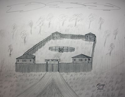
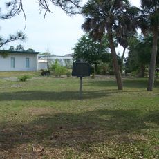
Fort Peyton, Military fort in St. Augustine, Florida, US.

Fort Peyton was a military outpost in St. Augustine with four log buildings arranged in a square pattern around a central area. The buildings served different purposes including barracks for soldiers, quarters for officers, and combined facilities for medical care and supply storage.

The outpost was founded in August 1837 by Major General Thomas S. Jesup during the Second Seminole War to protect the St. Augustine region. It was originally called Fort Moultrie before being renamed after an officer who commanded the garrison.

The location holds meaning as a site where American forces and Seminole people encountered each other during a turbulent period. Visitors today can reflect on what this place represents in the broader story of indigenous resistance.

Today the fort is marked by a concrete monument located on Arrowhead Drive. The site sits roughly a quarter mile north of Winterhawk Drive and is easy to visit.

The fort was originally called Fort Moultrie before being renamed to honor Lieutenant Richard H. Peyton, who commanded the post in 1837. This name change reflects how individual officers shaped the place's story.

The community of curious travelers

AroundUs brings together thousands of curated places, local tips, and hidden gems, enriched daily by 60,000 contributors worldwide.

Start exploring
Inception
August 1837
GPS coordinates
29.82472,-81.36000
Latest update
December 12, 2025 12:08
Around this place
Ponce de León Hotel
United States of America

Ponce de León Hotel

8.7 km
Lightner Museum
United States of America

Lightner Museum

8.6 km
Villa Zorayda
United States of America

Villa Zorayda

8.6 km
González-Alvarez House
United States of America

González-Alvarez House

8.5 km
Lincolnville Historic District
United States of America

Lincolnville Historic District

8 km
Ximenez-Fatio House
United States of America

Ximenez-Fatio House

8.7 km
Markland
United States of America

Markland

8.5 km
St. Augustine Town Plan Historic District
United States of America

St. Augustine Town Plan Historic District

8.7 km
Grace United Methodist Church
United States of America

Grace United Methodist Church

7.3 km
Llambias House
United States of America

Llambias House

8.4 km
Spanish Military Hospital Museum
United States of America

Spanish Military Hospital Museum

8.8 km
Potter's Wax Museum
United States of America

Potter's Wax Museum

8.8 km
St. Benedict the Moor School
United States of America

St. Benedict the Moor School

8.2 km
Segui-Kirby Smith House
United States of America

Segui-Kirby Smith House

8.8 km
Lindsley House
United States of America

Lindsley House

8.7 km
Xavier Lopez House
United States of America

Xavier Lopez House

8.5 km
O'Reilly House
United States of America

O'Reilly House

8.7 km
Solla-Carcaba Cigar Factory
United States of America

Solla-Carcaba Cigar Factory

8.4 km
Fort Hanson
United States of America

Fort Hanson

0 m
Sanchez Powder House Site
United States of America

Sanchez Powder House Site

8.1 km
Lincolnville Museum and Cultural Center
United States of America

Lincolnville Museum and Cultural Center

8 km
Model Land Company Historic District
United States of America

Model Land Company Historic District

8.7 km
Record Building
United States of America

Record Building

8.5 km
Stanbury Cottage
United States of America

Stanbury Cottage

8.7 km
Moultrie Church
United States of America

Moultrie Church

2.6 km
Villa Zorayda Museum
United States of America

Villa Zorayda Museum

8.6 km
First Colony: Our Spanish Origins Exhibit at Government House Museum
United States of America

First Colony: Our Spanish Origins Exhibit at Government House Museum

8.8 km
Statue of Juan Ponce de León
United States of America

Statue of Juan Ponce de León

8.9 km
Show the full map
« Fort Peyton - Military fort in St. Augustine, Florida, US » is provided by Around Us (aroundus.com). Images and texts are derived from Wikimedia project under a Creative Commons license. You are allowed to copy, distribute, and modify copies of this page, under the conditions set by the license, as long as this note is clearly visible.

Discover hidden gems everywhere you go!

From secret cafés to breathtaking viewpoints, skip the crowded tourist spots and find places that match your style. Our app makes it easy with voice search, smart filtering, route optimization, and insider tips from travelers worldwide. Download now for the complete mobile experience.

Around Us App Screenshot

A unique approach to discovering new places

Le Figaro

All the places worth exploring

France Info

A tailor-made excursion in just a few clicks

20 Minutes

Around Us
Travel Guide & Maps
Download

Send to your phone

QR Code
1

Open the camera app on your mobile.

2

Point at the QR code with your camera. A notification will appear.

3

Tap the notification to open the link.