O'Neill Dam

Log in to your account

AroundUs is a community-driven map of interesting places, built by curious explorers like you. It grows with every review, story, and photo you share.
Connect to save your favorite spots, contribute locations, and create personalized routes.
Continue with Google
Continue with Apple
Continue with X
Continue with Facebook
Continue with email
By continuing, you accept our Terms and Conditions and our Privacy Policy
Create an account
Add to collection
Map
Suggest a change
Share

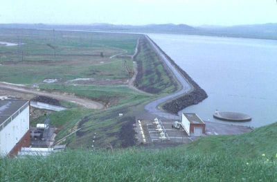
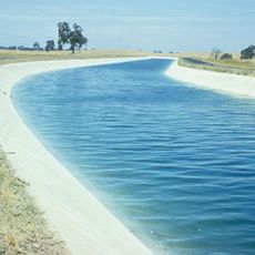
O'Neill Dam, Embankment dam in Merced County, United States.

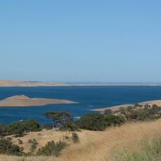
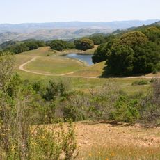
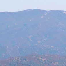
O'Neill Dam is an embankment structure that crosses the San Luis Creek valley in California and creates a large reservoir with multiple shoreline areas. The water body provides space for various water-based activities and is fed through irrigation channels from larger waterways.

The dam was constructed between 1963 and 1967 by the Bureau of Reclamation as part of a major irrigation project for the valley. Its completion marked an important step in moving water from northern sources to agricultural areas in the south.

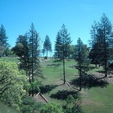
The forebay serves as a recreation hub for people from the surrounding region who come for fishing, boating, and weekend outings. It has become a regular gathering place for water lovers and families seeking outdoor activities.

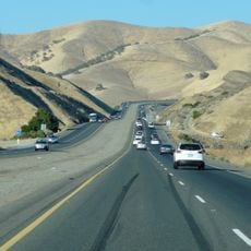
The dam is located roughly 20 kilometers west of Los Banos along a major highway and is easily accessible by car. Visitors should note that the location sits in a dry region and water levels vary seasonally throughout the year.

The dam is managed by a special spillway with a circular funnel design that looks like a giant bathtub drain when in operation. This unusual system regulates water flow in an automatic way without requiring moving parts to function.

Location: Merced County

GPS coordinates: 37.08050,-121.04700

Latest update: December 14, 2025 09:46

Photos
Around this place
San Luis Reservoir
United States of America

San Luis Reservoir

3.3 km
Henry W. Coe State Park
United States of America

Henry W. Coe State Park

45.8 km
Pacheco Pass
United States of America

Pacheco Pass

15.4 km
Delta–Mendota Canal
United States of America

Delta–Mendota Canal

1.5 km
Pacheco State Park
United States of America

Pacheco State Park

14 km
San Luis National Wildlife Refuge
United States of America

San Luis National Wildlife Refuge

26.2 km
Merced National Wildlife Refuge
United States of America

Merced National Wildlife Refuge

35.7 km
Randall Fawcett House
United States of America

Randall Fawcett House

21.2 km
San Juan Bautista State Historic Park
United States of America

San Juan Bautista State Historic Park

50.6 km
Sierra Azul Open Space Preserve
United States of America

Sierra Azul Open Space Preserve

21.4 km
Mount Sizer
United States of America

Mount Sizer

44 km
Jose Castro House
United States of America

Jose Castro House

50.7 km
Mount Stakes
United States of America

Mount Stakes

41.9 km
Wings of History Museum
United States of America

Wings of History Museum

49.2 km
Old City Hall
United States of America

Old City Hall

47.1 km
Juan de Anza House
United States of America

Juan de Anza House

50.8 km
Bloss Mansion
United States of America

Bloss Mansion

49.2 km
Church of St. Joseph
United States of America

Church of St. Joseph

17.7 km
Hollister Carnegie Library
United States of America

Hollister Carnegie Library

40.6 km
Bank of Los Banos Building
United States of America

Bank of Los Banos Building

17.9 km
Rozas House
United States of America

Rozas House

51 km
Gilroy Free Library
United States of America

Gilroy Free Library

47.3 km
Buhach Grammar School
United States of America

Buhach Grammar School

49.7 km
Benjamin Wilcox House
United States of America

Benjamin Wilcox House

50.9 km
Edgar Holloway House
United States of America

Edgar Holloway House

47.1 km
Marentis House
United States of America

Marentis House

51.1 km
Guadalupe River Park & Gardens
United States of America

Guadalupe River Park & Gardens

45.7 km
Highway 152 Tree Row
United States of America

Highway 152 Tree Row

50.9 km
Show the full map
Reviews

Visited this place? Tap the stars to rate it and share your experience / photos with the community! Try now! You can cancel it anytime.

« O'Neill Dam - Embankment dam in Merced County, United States » is provided by Around Us (aroundus.com). Images and texts are derived from Wikimedia project under a Creative Commons license. You are allowed to copy, distribute, and modify copies of this page, under the conditions set by the license, as long as this note is clearly visible.

Discover hidden gems everywhere you go!

From secret cafés to breathtaking viewpoints, skip the crowded tourist spots and find places that match your style. Our app makes it easy with voice search, smart filtering, route optimization, and insider tips from travelers worldwide. Download now for the complete mobile experience.

Around Us App Screenshot

A unique approach to discovering new places

Le Figaro

All the places worth exploring

France Info

A tailor-made excursion in just a few clicks

20 Minutes