Chest opened
+${chestReward.xp} XP
Explorer
NOUVEAU ×${chestReward.collectible.quantity}
tapez pour fermer
Chest locked

Open chests in the app

Around Us is built for your phone — chests unlock when you walk, explore and capture nearby places.

Enable Location

We need your location to show you interesting places around you

Discover nearby places

Find interesting locations and hidden gems around you

Precise directions

Get accurate directions and distances to places

Your location is never shared with other users. It's only used when you tap the location button.

Indian Rock Park

Log in to your account

Start exploring — it's free

Trusted by 72,941 travelers worldwide

Continue with Google
Continue with Apple
or

We will send you a code to connect

By continuing, you accept our Terms and Conditions and our Privacy Policy

Check your inbox

We've sent a pincode in your inbox. Please enter the code below.

Indian Rock Park
Discussion Reviews 1 Photos
12.4k Popularity

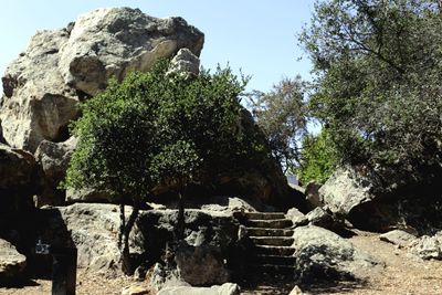
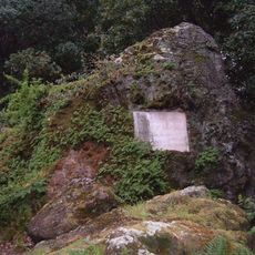
Indian Rock Park, Public rock park in Berkeley Hills, California.

Indian Rock Park is a public space in the Berkeley Hills featuring a large rhyolite boulder on its western side along with smaller rock outcroppings scattered about. The park includes open grass areas and tables where people can rest and eat.

The land was given to the public by Duncan McDuffie in 1917 as the Northbrae area was being developed nearby. Stairs were added later through Depression-era public works projects, making the main rock easier to reach.

The rock holds grinding pits carved by the Huichin band of the Ohlones, marking where people once gathered and prepared food. These pits are visible reminders of indigenous use that stretches back generations.

The park sits near Indian Rock Avenue, roughly two blocks north of Arlington/Marin Circle, with parking spaces available nearby. Visiting early in the day helps you avoid crowds and enjoy the views with fewer people around.

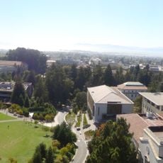
The site serves as a training ground where rock climbers practice on the rhyolite formations. The elevated location also opens up views across the East Bay, allowing visitors to see the university campus, Oakland below, and the bay in the distance.

The community of curious travelers

AroundUs brings together thousands of curated places, local tips, and hidden gems, enriched daily by 60,000 contributors worldwide.

Start exploring
Location
GPS coordinates
37.89220,-122.27300
Latest update
December 7, 2025 20:45
Around this place
Campus of the University of California, Berkeley
United States of America

Campus of the University of California, Berkeley

2.2 km
Berkeley Art Museum - Pacific Film Archive
United States of America

Berkeley Art Museum - Pacific Film Archive

2.4 km
Gourmet Ghetto
United States of America

Gourmet Ghetto

1.4 km
Berkeley Repertory Theatre
United States of America

Berkeley Repertory Theatre

2.4 km
Evans Hall
United States of America

Evans Hall

2.5 km
University of California Museum of Paleontology
United States of America

University of California Museum of Paleontology

2.5 km
Hearst Memorial Mining Building
United States of America

Hearst Memorial Mining Building

2.5 km
Hillside Elementary School
United States of America

Hillside Elementary School

1.9 km
Berkeley Rose Garden
United States of America

Berkeley Rose Garden

1.2 km
University House, Berkeley
United States of America

University House, Berkeley

2.2 km
United States of America

Keystone

2.2 km
The Freight and Salvage
United States of America

The Freight and Salvage

2.4 km
Casa Zimbabwe
United States of America

Casa Zimbabwe

2.1 km
Tilden Park Merry-Go-Round
United States of America

Tilden Park Merry-Go-Round

1.8 km
California Hall
United States of America

California Hall

2.5 km
UC Theatre
United States of America

UC Theatre

2.3 km
Founders' Rock
United States of America

Founders' Rock

2.4 km
Museum of Vertebrate Zoology
United States of America

Museum of Vertebrate Zoology

2.5 km
Ashkenaz
United States of America

Ashkenaz

2.4 km
Hillside Club
United States of America

Hillside Club

2.2 km
Stebbins Hall
United States of America

Stebbins Hall

2.2 km
Donald and Helen Olsen House
United States of America

Donald and Helen Olsen House

438 m
Studio Building
United States of America

Studio Building

2.3 km
John Hinkel Park
United States of America

John Hinkel Park

344 m
Sunset Mausoleum and Columbarium
United States of America

Sunset Mausoleum and Columbarium

2 km
Valley Life Sciences Building
United States of America

Valley Life Sciences Building

2.5 km
Kensington Library
United States of America

Kensington Library

2.4 km
Albany Library
United States of America

Albany Library

1.8 km
Show the full map
Reviews
Share your experience

No review yet

Discussions
Start a discussion...

No discussion yet

« Indian Rock Park - Public rock park in Berkeley Hills, California » is provided by Around Us (aroundus.com). Images and texts are derived from Wikimedia project under a Creative Commons license. You are allowed to copy, distribute, and modify copies of this page, under the conditions set by the license, as long as this note is clearly visible.

Discover hidden gems everywhere you go!

From secret cafés to breathtaking viewpoints, skip the crowded tourist spots and find places that match your style. Our app makes it easy with voice search, smart filtering, route optimization, and insider tips from travelers worldwide. Download now for the complete mobile experience.

Around Us App Screenshot

A unique approach to discovering new places

Le Figaro

All the places worth exploring

France Info

A tailor-made excursion in just a few clicks

20 Minutes

Around Us
Travel Guide & Maps
Download

Send to your phone

QR Code
1

Open the camera app on your mobile.

2

Point at the QR code with your camera. A notification will appear.

3

Tap the notification to open the link.