Enable Location

We need your location to show you interesting places around you

Discover nearby places

Find interesting locations and hidden gems around you

Precise directions

Get accurate directions and distances to places

Your location is never shared with other users. It's only used when you tap the location button.

Log in to your account

Start exploring — it's free

Trusted by 62,502 travelers worldwide

Continue with Google
Continue with Apple
or

We will send you a code to connect

By continuing, you accept our Terms and Conditions and our Privacy Policy

Check your inbox

We've sent a pincode in your inbox. Please enter the code below.

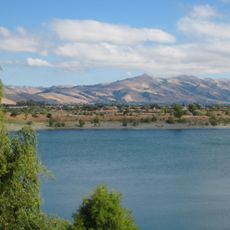
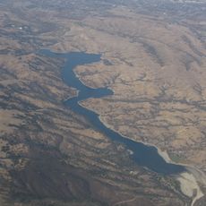
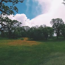
Shadow Cliffs Regional Park, Regional park with 80-acre lake in Pleasanton, United States.

Shadow Cliffs is a regional park with an 80-acre lake surrounded by hiking trails, picnic areas, and a swimming beach. The 266-acre site offers boating, fishing, and various recreational facilities along the shoreline.

The park was created in the 1970s from the site of a former gravel quarry, transforming an industrial area into a public recreation space. This conversion demonstrates how abandoned mining operations can be successfully reclaimed as nature reserves.

Birdwatchers and nature enthusiasts gather regularly to observe ducks, herons, and seasonal migrating birds throughout the year. The lake has become a focal point for wildlife observation and quiet moments spent connecting with nature.

The park is open daily with ample parking near the lake and beach areas. Bring plenty of water and sun protection, as shade can be limited in some spots.

The lake was not formed naturally but created by filling the abandoned gravel pit with water, which defines its shape and depth. This unusual origin makes it an interesting example of how nature can flourish in places humans have transformed.

The community of curious travelers

AroundUs brings together thousands of curated places, local tips, and hidden gems, enriched daily by 60,000 contributors worldwide.

Start exploring
Location
Inception
1971
Operator
East Bay Regional Park District
GPS coordinates
37.66940,-121.83900
Latest update
December 12, 2025 09:03
Around this place
Centennial Light
United States of America

Centennial Light

8.9 km
Federal Correctional Institution, Dublin
United States of America

Federal Correctional Institution, Dublin

7.5 km
Mission San José
United States of America

Mission San José

16.8 km
Mission Peak
United States of America

Mission Peak

17.8 km
Altamont Pass
United States of America

Altamont Pass

18 km
Santa Rita Jail
United States of America

Santa Rita Jail

6.9 km
Niles Canyon
United States of America

Niles Canyon

14.9 km
Sunol Water Temple
United States of America

Sunol Water Temple

10.2 km
Blackhawk Museum
United States of America

Blackhawk Museum

16.2 km
Sunol Regional Wilderness
United States of America

Sunol Regional Wilderness

17.7 km
Hacienda del Pozo de Verona
United States of America

Hacienda del Pozo de Verona

6.1 km
Quarry Lakes Regional Recreation Area
United States of America

Quarry Lakes Regional Recreation Area

18 km
Del Valle Regional Park
United States of America

Del Valle Regional Park

14.2 km
Golden Gate Railroad Museum
United States of America

Golden Gate Railroad Museum

10.6 km
Niles Essanay Silent Film Museum
United States of America

Niles Essanay Silent Film Museum

16.1 km
Forest Home Farms
United States of America

Forest Home Farms

12.2 km
Alviso Adobe Community Park
United States of America

Alviso Adobe Community Park

6.5 km
San Antonio Reservoir
United States of America

San Antonio Reservoir

9.9 km
Vallejo Flour Mill
United States of America

Vallejo Flour Mill

15.3 km
Don Castro Regional Recreation Area
United States of America

Don Castro Regional Recreation Area

18.8 km
Pleasanton Public Library
United States of America

Pleasanton Public Library

3.9 km
Livermore Carnegie Library and Park
United States of America

Livermore Carnegie Library and Park

6.3 km
Ohlone Wilderness
United States of America

Ohlone Wilderness

18 km
Holy Cross Orthodox Monastery
United States of America

Holy Cross Orthodox Monastery

10.7 km
Niles Depot Museum
United States of America

Niles Depot Museum

16 km
Doolan Canyon
United States of America

Doolan Canyon

4.2 km
Sunol
United States of America

Sunol

9.5 km
Museum on Main
United States of America

Museum on Main

3.3 km
Show the full map
« Shadow Cliffs Regional Park - Regional park with 80-acre lake in Pleasanton, United States » is provided by Around Us (aroundus.com). Images and texts are derived from Wikimedia project under a Creative Commons license. You are allowed to copy, distribute, and modify copies of this page, under the conditions set by the license, as long as this note is clearly visible.

Discover hidden gems everywhere you go!

From secret cafés to breathtaking viewpoints, skip the crowded tourist spots and find places that match your style. Our app makes it easy with voice search, smart filtering, route optimization, and insider tips from travelers worldwide. Download now for the complete mobile experience.

Around Us App Screenshot

A unique approach to discovering new places

Le Figaro

All the places worth exploring

France Info

A tailor-made excursion in just a few clicks

20 Minutes

Around Us
Travel Guide & Maps
Download

Send to your phone

QR Code
1

Open the camera app on your mobile.

2

Point at the QR code with your camera. A notification will appear.

3

Tap the notification to open the link.