Enable Location

We need your location to show you interesting places around you

Discover nearby places

Find interesting locations and hidden gems around you

Precise directions

Get accurate directions and distances to places

Your location is never shared with other users. It's only used when you tap the location button.

Dr. Aurelia Reinhardt Redwood Regional Park

Log in to your account

Start exploring — it's free

Trusted by travelers worldwide

Continue with Google
Continue with Apple
or

We will send you a code to connect

By continuing, you accept our Terms and Conditions and our Privacy Policy

Check your inbox

We've sent a pincode in your inbox. Please enter the code below.

Dr. Aurelia Reinhardt Redwood Regional Park, Regional park in Oakland hills, United States.

Description

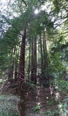
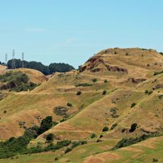
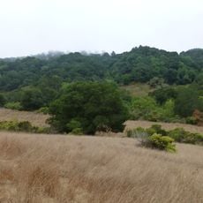
Dr. Aurelia Reinhardt Redwood Regional Park is an 1,833-acre protected area in the Oakland hills containing the largest natural stand of coast redwoods in the East Bay. These trees stand as the forest's tallest residents, with some exceeding 150 feet.

History

Heavy logging in the 1800s removed much of the original forest to provide lumber for Bay Area development. The trees visible today grew back over generations, forming what is now called a third-growth forest.

Culture

The park's name honors Dr. Aurelia Reinhardt, a Mills College president who helped establish the Park District Board in its early years. This dedication reflects the community's commitment to recognizing local leaders who shaped public lands.

Practical

The park provides about 40 miles of trails suitable for hiking, jogging, and horseback riding across different forest sections. Entrances are clearly marked and parking is available at multiple gates, with fees charged during the warmer months.

Did you know?

One original redwood tree survives near Merritt College, rising 93 feet from a rocky outcrop that prevented loggers from reaching it. This tree escaped the saw because of its impossible-to-access location on the stone face.

Location
Operator
East Bay Regional Park District
GPS coordinates
37.81356,-122.16592
Latest update
December 8, 2025 19:59

AroundUs brings together thousands of curated places, local tips, and hidden gems, enriched daily by 60,000 contributors worldwide. Discover all places nearby (Alameda County).

Around this place
Oakland Coliseum
United States of America

Oakland Coliseum

7.5 km
Chabot Space and Science Center
United States of America

Chabot Space and Science Center

1.4 km
Oakland Zoo
United States of America

Oakland Zoo

7.2 km
Head-Royce School
United States of America

Head-Royce School

3.5 km
Oakland Buddha Shrine
United States of America

Oakland Buddha Shrine

7.2 km
Grand Lake Theatre
United States of America

Grand Lake Theatre

7.1 km
Robert Sibley Volcanic Regional Preserve
United States of America

Robert Sibley Volcanic Regional Preserve

5.7 km
McKeon Pavilion
United States of America

McKeon Pavilion

6.1 km
Anthony Chabot Regional Park
United States of America

Anthony Chabot Regional Park

6 km
Maynard Buehler House
United States of America

Maynard Buehler House

5.5 km
Ordinaire
United States of America

Ordinaire

7.1 km
Fruitvale Bridge
United States of America

Fruitvale Bridge

7.5 km
Joaquin Miller House
United States of America

Joaquin Miller House

2.4 km
United States of America

Round Top

4.7 km
Park Street Bridge
United States of America

Park Street Bridge

7.8 km
Leimert Bridge
United States of America

Leimert Bridge

4.1 km
High Street Bridge
United States of America

High Street Bridge

7.5 km
Huckleberry Botanic Regional Preserve
United States of America

Huckleberry Botanic Regional Preserve

4.1 km
Upper San Leandro Reservoir
United States of America

Upper San Leandro Reservoir

6 km
Sequoyah Country Club
United States of America

Sequoyah Country Club

6 km
Moraga Adobe
United States of America

Moraga Adobe

3.5 km
William Joseph McInnes Botanic Garden and Campus Arboretum
United States of America

William Joseph McInnes Botanic Garden and Campus Arboretum

3.9 km
Temescal Regional Recreation Area
United States of America

Temescal Regional Recreation Area

6.9 km
Oakland Harbor Light
United States of America

Oakland Harbor Light

7.8 km
Kehilla Community Synagogue
United States of America

Kehilla Community Synagogue

6.9 km
White Mansion
United States of America

White Mansion

7.6 km
Labadie Arboretum
United States of America

Labadie Arboretum

2.2 km
Mills Hall
United States of America

Mills Hall

4 km
Show the full map
« Dr. Aurelia Reinhardt Redwood Regional Park - Regional park in Oakland hills, United States » is provided by Around Us (aroundus.com). Images and texts are derived from Wikimedia project under a Creative Commons license. You are allowed to copy, distribute, and modify copies of this page, under the conditions set by the license, as long as this note is clearly visible.

Discover hidden gems everywhere you go!

From secret cafés to breathtaking viewpoints, skip the crowded tourist spots and find places that match your style. Our app makes it easy with voice search, smart filtering, route optimization, and insider tips from travelers worldwide. Download now for the complete mobile experience.

Around Us App Screenshot

A unique approach to discovering new places

Le Figaro

All the places worth exploring

France Info

A tailor-made excursion in just a few clicks

20 Minutes

Around Us
Travel Guide & Maps
Download

Send to your phone

QR Code
1

Open the camera app on your mobile.

2

Point at the QR code with your camera. A notification will appear.

3

Tap the notification to open the link.