Enable Location

We need your location to show you interesting places around you

Discover nearby places

Find interesting locations and hidden gems around you

Precise directions

Get accurate directions and distances to places

Your location is never shared with other users. It's only used when you tap the location button.

Confusion Hill

Log in to your account

Start exploring — it's free

Trusted by 62,943 travelers worldwide

Continue with Google
Continue with Apple
or

We will send you a code to connect

By continuing, you accept our Terms and Conditions and our Privacy Policy

Check your inbox

We've sent a pincode in your inbox. Please enter the code below.

Confusion Hill
Discussion Reviews 1 Photos
19.5k Popularity

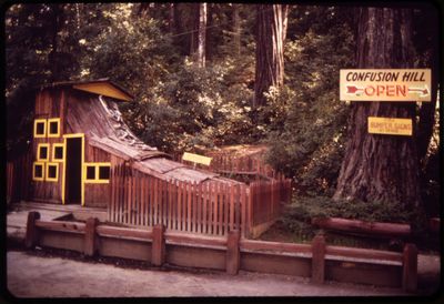
Confusion Hill, Optical illusion amusement park in Piercy, California, United States.

Confusion Hill is an optical illusion amusement park in Piercy, California, focused on playful experiments with gravity and perspective. The Gravity House features tilted floors and skewed walls that produce puzzling visual effects.

The park opened in 1949 along the Pacific Coast Highway and received recognition as a California State Point of Historical Interest in January 2010. This designation honors its role in American roadside attraction history.

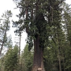
The attraction preserves midcentury American roadside entertainment traditions and displays the world's largest freestanding chainsaw-carved redwood totem pole. This handcrafted woodwork reflects regional logging heritage along the highway corridor.

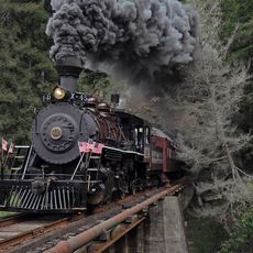
The site sits about 25 miles (40 kilometers) south of Avenue of the Giants and offers a miniature train ride, gift shop, and playground. The facility suits families with children and allows for roughly an hour-long visit.

Visitors witness phenomena where balls seem to roll uphill and people stand at impossible angles. These effects result from deliberately engineered architectural illusions within the tilted building.

The community of curious travelers

AroundUs brings together thousands of curated places, local tips, and hidden gems, enriched daily by 60,000 contributors worldwide.

Start exploring
GPS coordinates
39.91892,-123.76494
Latest update
December 5, 2025 22:29
Around this place
Glass Beach
United States of America

Glass Beach

52 km
Chandelier Tree
United States of America

Chandelier Tree

7.8 km
Humboldt Redwoods State Park
United States of America

Humboldt Redwoods State Park

47.2 km
California Western Railroad
United States of America

California Western Railroad

52.8 km
MacKerricher State Park
United States of America

MacKerricher State Park

47.4 km
King Range
United States of America

King Range

41.7 km
Patrick's Point State Park
United States of America

Patrick's Point State Park

41.5 km
Richardson Grove State Park
United States of America

Richardson Grove State Park

11.3 km
Sinkyone Wilderness State Park
United States of America

Sinkyone Wilderness State Park

14.9 km
Mendocino Coast Botanical Gardens
United States of America

Mendocino Coast Botanical Gardens

56.9 km
Westport-Union Landing State Beach
United States of America

Westport-Union Landing State Beach

27 km
Confusion Hill Bridges
United States of America

Confusion Hill Bridges

313 m
South Fork Eel River Wilderness
United States of America

South Fork Eel River Wilderness

10.1 km
Benbow Lake State Recreation Area
United States of America

Benbow Lake State Recreation Area

16.1 km
King Range Wilderness
United States of America

King Range Wilderness

41.7 km
Benbow Inn
United States of America

Benbow Inn

16.7 km
Noyo River Bridge
United States of America

Noyo River Bridge

54.8 km
Weller House
United States of America

Weller House

52.6 km
United States of America

Signal Peak

49.6 km
Seaside Creek Beach
United States of America

Seaside Creek Beach

40 km
Ten Mile Beach
United States of America

Ten Mile Beach

43.7 km
Pudding Creek Beach
United States of America

Pudding Creek Beach

51.7 km
Union Lumber Company Store
United States of America

Union Lumber Company Store

52.9 km
Noyo Harbor Beach
United States of America

Noyo Harbor Beach

55.1 km
Laguna Point Beach
United States of America

Laguna Point Beach

47.8 km
Wages Creek Beach
United States of America

Wages Creek Beach

29.8 km
Hare Creek Bridge
United States of America

Hare Creek Bridge

55.8 km
Pudding Creek Trestle
United States of America

Pudding Creek Trestle

51.3 km
Show the full map
Reviews
Share your experience

No review yet

Discussions
Start a discussion...

No discussion yet

« Confusion Hill - Optical illusion amusement park in Piercy, California, United States » is provided by Around Us (aroundus.com). Images and texts are derived from Wikimedia project under a Creative Commons license. You are allowed to copy, distribute, and modify copies of this page, under the conditions set by the license, as long as this note is clearly visible.

Discover hidden gems everywhere you go!

From secret cafés to breathtaking viewpoints, skip the crowded tourist spots and find places that match your style. Our app makes it easy with voice search, smart filtering, route optimization, and insider tips from travelers worldwide. Download now for the complete mobile experience.

Around Us App Screenshot

A unique approach to discovering new places

Le Figaro

All the places worth exploring

France Info

A tailor-made excursion in just a few clicks

20 Minutes

Around Us
Travel Guide & Maps
Download

Send to your phone

QR Code
1

Open the camera app on your mobile.

2

Point at the QR code with your camera. A notification will appear.

3

Tap the notification to open the link.