Log in to your account

AroundUs is a community-driven map of interesting places, built by curious explorers like you. It grows with every review, story, and photo you share.
Connect to save your favorite spots, contribute locations, and create personalized routes.
Continue with Google
Continue with Apple
Continue with X
Continue with Facebook
Continue with email
By continuing, you accept our Terms and Conditions and our Privacy Policy
Create an account

Spenceville Wildlife Area

Add to collection
Map
Suggest a change
Share

Spenceville Wildlife Area, Protected wildlife area in Sierra Nevada Foothills, California

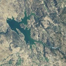
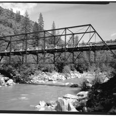
Spenceville Wildlife Area is a protected reserve in the Sierra Nevada Foothills covering more than 11,000 acres of diverse habitats. The terrain shifts between oak forests, open grasslands, and riparian woodlands across varying elevations.

The area was acquired by California's fish and game agency in 1962 and formally established as a protected wildlife area in 1968. This designation reflected growing efforts to preserve the region's natural habitats.

The land holds archaeological evidence of Maidu and Nisenan Native Americans through grinding holes and lodge pits visible across the site. These remnants show how indigenous peoples lived here and used the natural resources for generations.

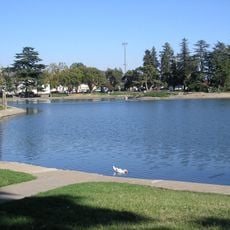
Visitors can hike, bike, hunt, ride horses, and camp in designated areas throughout the reserve. It helps to learn about different zones beforehand since some sections may have restrictions or specific seasonal rules.

The area sits atop the Smartville Block, a geological formation from the Middle Jurassic period rich in gold deposits. These mineral resources sparked significant mining activity in earlier times.

Location: California

GPS coordinates: 39.14440,-121.31700

Latest update: December 11, 2025 18:07

Photos
Around this place
Empire Mine State Historic Park
United States of America

Empire Mine State Historic Park

24.5 km
South Yuba River State Park
United States of America

South Yuba River State Park

19.6 km
Bridgeport Covered Bridge
United States of America

Bridgeport Covered Bridge

19.6 km
Bok Kai Temple
United States of America

Bok Kai Temple

23.3 km
Englebright Lake
United States of America

Englebright Lake

11.4 km
Home of Lola Montez
United States of America

Home of Lola Montez

23.3 km
Camp Far West Reservoir
United States of America

Camp Far West Reservoir

10.3 km
Ellis Lake
United States of America

Ellis Lake

23.3 km
North Star House
United States of America

North Star House

21.5 km
Nevada City Downtown Historic District
United States of America

Nevada City Downtown Historic District

28.9 km
Englebright Dam
United States of America

Englebright Dam

11.4 km
Mount Saint Mary's Convent and Academy
United States of America

Mount Saint Mary's Convent and Academy

22.9 km
Nevada Theatre
United States of America

Nevada Theatre

28.8 km
Grass Valley Public Library
United States of America

Grass Valley Public Library

23.3 km
Doris Foley Library for Historical Research
United States of America

Doris Foley Library for Historical Research

28.9 km
Community Memorial Museum of Sutter County
United States of America

Community Memorial Museum of Sutter County

27.5 km
Yuba City Astronomical Observatory
United States of America

Yuba City Astronomical Observatory

27.6 km
Hart Building
United States of America

Hart Building

23.5 km
Packard Library
United States of America

Packard Library

23.4 km
Martin Luther Marsh House
United States of America

Martin Luther Marsh House

29.9 km
Trinity Church (Nevada City)
United States of America

Trinity Church (Nevada City)

29.1 km
Aaron A. Sargent House
United States of America

Aaron A. Sargent House

28.8 km
Marysville Historic Commercial District
United States of America

Marysville Historic Commercial District

23.5 km
Ott's Assay Office
United States of America

Ott's Assay Office

29.2 km
Northstar Mining Museum
United States of America

Northstar Mining Museum

22.5 km
Grass Valley Library-Royce Branch
United States of America

Grass Valley Library-Royce Branch

23.3 km
Purdon Crossing Bridge
United States of America

Purdon Crossing Bridge

31 km
Yuba County Library
United States of America

Yuba County Library

23.4 km
Show the full map
Reviews

Visited this place? Tap the stars to rate it and share your experience / photos with the community! Try now! You can cancel it anytime.

« Spenceville Wildlife Area - Protected wildlife area in Sierra Nevada Foothills, California » is provided by Around Us (aroundus.com). Images and texts are derived from Wikimedia project under a Creative Commons license. You are allowed to copy, distribute, and modify copies of this page, under the conditions set by the license, as long as this note is clearly visible.

Discover hidden gems everywhere you go!

From secret cafés to breathtaking viewpoints, skip the crowded tourist spots and find places that match your style. Our app makes it easy with voice search, smart filtering, route optimization, and insider tips from travelers worldwide. Download now for the complete mobile experience.

Around Us App Screenshot

A unique approach to discovering new places

Le Figaro

All the places worth exploring

France Info

A tailor-made excursion in just a few clicks

20 Minutes