Enable Location

We need your location to show you interesting places around you

Discover nearby places

Find interesting locations and hidden gems around you

Precise directions

Get accurate directions and distances to places

Your location is never shared with other users. It's only used when you tap the location button.

Burney Falls

Log in to your account

Start exploring — it's free

Trusted by 63,014 travelers worldwide

Continue with Google
Continue with Apple
or

We will send you a code to connect

By continuing, you accept our Terms and Conditions and our Privacy Policy

Check your inbox

We've sent a pincode in your inbox. Please enter the code below.

Discussion Reviews 2 Photos
72.9k Popularity

Burney Falls, Waterfall in McArthur-Burney Falls Memorial State Park, California, US

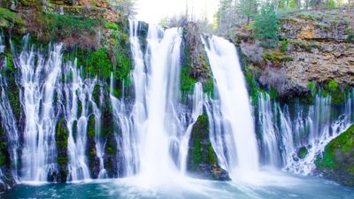
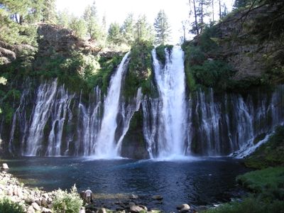
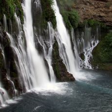
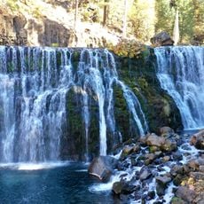
Burney Falls is a waterfall in McArthur-Burney Falls Memorial State Park, California, where water drops 39 meters (129 feet) over basalt cliffs in a wide cascade. The flow spans 76 meters (250 feet) across, with numerous springs emerging directly from the porous rock face to create additional curtains of water.

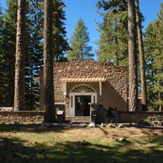
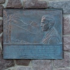
The state of California established the park in 1921 to permanently protect the falls and provide public access to the site. President Theodore Roosevelt visited in the early 20th century and described them in his accounts as noteworthy.

The name honors Samuel Burney, an early settler who lived in the area during the 1850s. Visitors often notice the cool microclimate near the water, which contrasts sharply with the dry air of the surrounding forest.

Several viewing platforms are accessible via paved paths that descend from the parking lot to the base below. Sturdy footwear is advisable since the paths can become wet from the spray.

Underground springs feed the falls with roughly 379 million liters (100 million gallons) of water daily, regardless of rainfall or season. This constant volume makes the waterfall impressive throughout the year.

The community of curious travelers

AroundUs brings together thousands of curated places, local tips, and hidden gems, enriched daily by 60,000 contributors worldwide.

Start exploring
Location
GPS coordinates
41.01195,-121.65197
Latest update
December 13, 2025 17:26
Around this place
Allen Telescope Array
United States of America

Allen Telescope Array

26.3 km
Wyntoon
United States of America

Wyntoon

39.9 km
McArthur-Burney Falls Memorial State Park
United States of America

McArthur-Burney Falls Memorial State Park

774 m
Lake Britton
United States of America

Lake Britton

2.2 km
Ahjumawi Lava Springs State Park
United States of America

Ahjumawi Lava Springs State Park

24 km
Hat Creek Radio Observatory
United States of America

Hat Creek Radio Observatory

26.3 km
Thousand Lakes Wilderness
United States of America

Thousand Lakes Wilderness

35.2 km
Nobles Emigrant Trail
United States of America

Nobles Emigrant Trail

55.2 km
Dunsmuir Botanical Gardens
United States of America

Dunsmuir Botanical Gardens

45 km
Loomis Museum
United States of America

Loomis Museum

53.5 km
Pit 3 Dam
United States of America

Pit 3 Dam

2.3 km
Fort Crook
United States of America

Fort Crook

14.4 km
Pit 6 Dam
United States of America

Pit 6 Dam

30.4 km
Manzanita Lake Naturalist's Services Historic District
United States of America

Manzanita Lake Naturalist's Services Historic District

53.5 km
Hot Rock
United States of America

Hot Rock

54.8 km
Discovery Center
United States of America

Discovery Center

53.4 km
Loomis Ranger Station
United States of America

Loomis Ranger Station

53.5 km
Seismograph Building
United States of America

Seismograph Building

53.5 km
Intermountain Fair
United States of America

Intermountain Fair

21.6 km
Seismograph
United States of America

Seismograph

53.5 km
Manzanita Ranger Residence
United States of America

Manzanita Ranger Residence

53.2 km
Chaos Jumbles
United States of America

Chaos Jumbles

53.4 km
Fort Crook Museum
United States of America

Fort Crook Museum

17.4 km
Mt. Burney Theatre
United States of America

Mt. Burney Theatre

14.6 km
Mather Plaque in Lassen Volcanic National Park
United States of America

Mather Plaque in Lassen Volcanic National Park

53.5 km
Manzanita Kiosk
United States of America

Manzanita Kiosk

53.2 km
Silver Lake
United States of America

Silver Lake

35.1 km
McCloud Falls (Lower, Middle, Upper)
United States of America

McCloud Falls (Lower, Middle, Upper)

39.5 km
Show the full map
Reviews
Share your experience

No review yet

Discussions
Start a discussion...

No discussion yet

« Burney Falls - Waterfall in McArthur-Burney Falls Memorial State Park, California, US » is provided by Around Us (aroundus.com). Images and texts are derived from Wikimedia project under a Creative Commons license. You are allowed to copy, distribute, and modify copies of this page, under the conditions set by the license, as long as this note is clearly visible.

Discover hidden gems everywhere you go!

From secret cafés to breathtaking viewpoints, skip the crowded tourist spots and find places that match your style. Our app makes it easy with voice search, smart filtering, route optimization, and insider tips from travelers worldwide. Download now for the complete mobile experience.

Around Us App Screenshot

A unique approach to discovering new places

Le Figaro

All the places worth exploring

France Info

A tailor-made excursion in just a few clicks

20 Minutes

Around Us
Travel Guide & Maps
Download

Send to your phone

QR Code
1

Open the camera app on your mobile.

2

Point at the QR code with your camera. A notification will appear.

3

Tap the notification to open the link.