Chest opened
+${chestReward.xp} XP
Explorer
NOUVEAU ×${chestReward.collectible.quantity}
tapez pour fermer
Chest locked

Open chests in the app

Around Us is built for your phone — chests unlock when you walk, explore and capture nearby places.

Enable Location

We need your location to show you interesting places around you

Discover nearby places

Find interesting locations and hidden gems around you

Precise directions

Get accurate directions and distances to places

Your location is never shared with other users. It's only used when you tap the location button.

Willamette River

Log in to your account

Start exploring — it's free

Trusted by 72,880 travelers worldwide

Continue with Google
Continue with Apple
or

We will send you a code to connect

By continuing, you accept our Terms and Conditions and our Privacy Policy

Check your inbox

We've sent a pincode in your inbox. Please enter the code below.

Willamette River
Discussion Reviews 4 Photos
82.5k Popularity

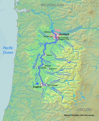
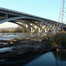
Willamette River, River system in western Oregon, United States

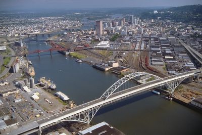
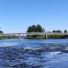
The Willamette River runs northward through western Oregon, creating a broad valley between two mountain ranges where most of the state's cities are located. It joins the Columbia River north of Portland after flowing roughly 300 kilometers.

Different tribes lived in this watershed for over ten thousand years before European settlers arrived in the 1840s and established farms along the banks. Over the following decades, several dams were built for flood control and energy production.

The name comes from a Clackamas village and recalls a time when different tribes fished for salmon and traded along the water. Today, parks and boat ramps line the banks where people walk, fish, or launch small craft.

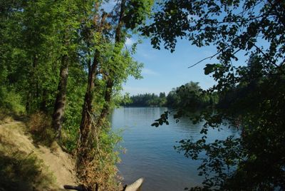
Paths and viewpoints along the waterway often lie within city parks or near smaller towns, making it easy to reach what you want to see on foot or by bike. Water levels can rise sharply during winter, so it helps to check conditions before visiting.

The watershed produces more runoff per area than most large rivers in the United States, with most water flowing between November and March. During dry summer months, the level drops noticeably and the appearance of the waterway changes dramatically.

The community of curious travelers

AroundUs brings together thousands of curated places, local tips, and hidden gems, enriched daily by 60,000 contributors worldwide.

Start exploring
Location
Location
GPS coordinates
44.02306,-123.02361
Latest update
December 13, 2025 16:25
Around this place
Hayward Field
United States of America

Hayward Field

4.4 km
Pre's Trail
United States of America

Pre's Trail

4.5 km
Jordan Schnitzer Museum of Art
United States of America

Jordan Schnitzer Museum of Art

4.9 km
Jane Sanders Stadium
United States of America

Jane Sanders Stadium

4.5 km
The Pioneer
United States of America

The Pioneer

4.9 km
Temple Beth Israel
United States of America

Temple Beth Israel

4.1 km
Hendricks Park
United States of America

Hendricks Park

3.1 km
The Pioneer Mother
United States of America

The Pioneer Mother

4.8 km
University of Oregon Museum of Natural and Cultural History
United States of America

University of Oregon Museum of Natural and Cultural History

4.2 km
Mount Pisgah Arboretum
United States of America

Mount Pisgah Arboretum

3.8 km
John von Neumann
United States of America

John von Neumann

4.6 km
Gerlinger Hall
United States of America

Gerlinger Hall

4.8 km
Washburne Historic District
United States of America

Washburne Historic District

2.8 km
Alan Turing
United States of America

Alan Turing

4.6 km
Johnson Hall
United States of America

Johnson Hall

4.8 km
MarAbel B. Frohnmayer Music Building
United States of America

MarAbel B. Frohnmayer Music Building

4.8 km
Brattain–Hadley House
United States of America

Brattain–Hadley House

3 km
Whilamut Passage Bridge
United States of America

Whilamut Passage Bridge

3.3 km
Knickerbocker Bicycle Bridge
United States of America

Knickerbocker Bicycle Bridge

3.4 km
Einstein Gargoyle
United States of America

Einstein Gargoyle

4.7 km
Maxwell & Demon Gargoyle
United States of America

Maxwell & Demon Gargoyle

4.7 km
Springfield General Hospital
United States of America

Springfield General Hospital

3.3 km
Cascade Charley
United States of America

Cascade Charley

4.8 km
Methodist Episcopal Church of Goshen
United States of America

Methodist Episcopal Church of Goshen

3.2 km
Chase Gardens Residential Grouping
United States of America

Chase Gardens Residential Grouping

4.6 km
Robert E. Campbell House
United States of America

Robert E. Campbell House

3.7 km
Howard A. Hall House
United States of America

Howard A. Hall House

4.1 km
Clarence and Ethel Boyer House
United States of America

Clarence and Ethel Boyer House

4.3 km
Show the full map
Reviews
Share your experience

No review yet

Discussions
Start a discussion...

No discussion yet

« Willamette River - River system in western Oregon, United States » is provided by Around Us (aroundus.com). Images and texts are derived from Wikimedia project under a Creative Commons license. You are allowed to copy, distribute, and modify copies of this page, under the conditions set by the license, as long as this note is clearly visible.

Discover hidden gems everywhere you go!

From secret cafés to breathtaking viewpoints, skip the crowded tourist spots and find places that match your style. Our app makes it easy with voice search, smart filtering, route optimization, and insider tips from travelers worldwide. Download now for the complete mobile experience.

Around Us App Screenshot

A unique approach to discovering new places

Le Figaro

All the places worth exploring

France Info

A tailor-made excursion in just a few clicks

20 Minutes

Around Us
Travel Guide & Maps
Download

Send to your phone

QR Code
1

Open the camera app on your mobile.

2

Point at the QR code with your camera. A notification will appear.

3

Tap the notification to open the link.