Enable Location

We need your location to show you interesting places around you

Discover nearby places

Find interesting locations and hidden gems around you

Precise directions

Get accurate directions and distances to places

Your location is never shared with other users. It's only used when you tap the location button.

Riffe Lake

Log in to your account

Start exploring — it's free

Trusted by 62,420 travelers worldwide

Continue with Google
Continue with Apple
or

We will send you a code to connect

By continuing, you accept our Terms and Conditions and our Privacy Policy

Check your inbox

We've sent a pincode in your inbox. Please enter the code below.

Riffe Lake

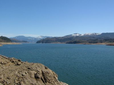
Riffe Lake, reservoir in Lewis County, Washington state, United States of America

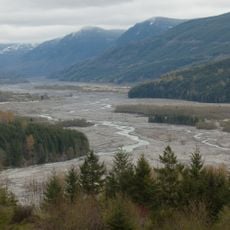
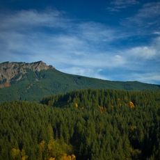
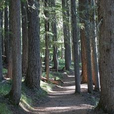
Riffe Lake is a reservoir in Lewis County, Washington, created by the Mossyrock Dam to control water flow and provide power to the region. The lake stretches through forested rolling hills and offers several access points including boat launches at Mossyrock Park and a fishing pier at Taidnapam Park.

The lake was formed when the Mossyrock Dam was constructed to manage water flow and generate electricity for the surrounding region. This infrastructure project transformed the local economy and established the area as a popular destination for recreation and fishing.

The lake is accessible year-round and easiest to reach via Highway 12 near the town of Mossyrock, where several boat ramps and picnic facilities are available. Plan ahead by checking local conditions and facilities, as parking fees apply on weekends and holidays during the summer months.

Taidnapam Park features a dedicated fishing pier that is popular with families and children, offering beginners an easy way to fish from shore. This pier is one of the quieter access points but becomes busy with young anglers on weekends.

The community of curious travelers

AroundUs brings together thousands of curated places, local tips, and hidden gems, enriched daily by 60,000 contributors worldwide.

Start exploring
Location
Location
Elevation above the sea
236 m
GPS coordinates
46.47778,-122.29584
Latest update
February 7, 2026 11:01
Around this place
Mount St. Helens
United States of America

Mount St. Helens

32.8 km
Ape Canyon
United States of America

Ape Canyon

34 km
Gifford Pinchot National Forest
United States of America

Gifford Pinchot National Forest

52.5 km
Crater Glacier
United States of America

Crater Glacier

32.4 km
Mount Rainier Scenic Railroad
United States of America

Mount Rainier Scenic Railroad

32.9 km
Ike Kinswa State Park
United States of America

Ike Kinswa State Park

20.8 km
Seaquest State Park
United States of America

Seaquest State Park

45.1 km
Lewis & Clark State Park
United States of America

Lewis & Clark State Park

40.1 km
Gospodor Monument Park
United States of America

Gospodor Monument Park

45.2 km
Glacier View Wilderness
United States of America

Glacier View Wilderness

44.9 km
Mount Wow
United States of America

Mount Wow

45 km
Gobbler's Knob Fire Lookout
United States of America

Gobbler's Knob Fire Lookout

45.7 km
Nisqually Entrance Historic District
United States of America

Nisqually Entrance Historic District

41.2 km
Lake George Patrol Cabin
United States of America

Lake George Patrol Cabin

46.3 km
Ashford Mansion
United States of America

Ashford Mansion

37.5 km
Lake Lawrence erratic
United States of America

Lake Lawrence erratic

48.2 km
Randle Ranger Station-Work Center
United States of America

Randle Ranger Station-Work Center

26.7 km
Recycled Spirits of Iron
United States of America

Recycled Spirits of Iron

33.3 km
National Park Inn
United States of America

National Park Inn

47.7 km
Longmire Campground Comfort Station No. L-302
United States of America

Longmire Campground Comfort Station No. L-302

47.6 km
Longmire Campground Comfort Station No. L-303
United States of America

Longmire Campground Comfort Station No. L-303

47.5 km
Longmire Community Building
United States of America

Longmire Community Building

47.7 km
Longmire General Store
United States of America

Longmire General Store

47.7 km
Rampart Ridge Trail
United States of America

Rampart Ridge Trail

47.6 km
Mount Rainier National Park Valor Memorial
United States of America

Mount Rainier National Park Valor Memorial

47.6 km
G Theatre
United States of America

G Theatre

15.6 km
Pickering Lumber Company 10
United States of America

Pickering Lumber Company 10

32.8 km
Eatonville Library
United States of America

Eatonville Library

43.4 km
Show the full map
« Riffe Lake - reservoir in Lewis County, Washington state, United States of America » is provided by Around Us (aroundus.com). Images and texts are derived from Wikimedia project under a Creative Commons license. You are allowed to copy, distribute, and modify copies of this page, under the conditions set by the license, as long as this note is clearly visible.

Discover hidden gems everywhere you go!

From secret cafés to breathtaking viewpoints, skip the crowded tourist spots and find places that match your style. Our app makes it easy with voice search, smart filtering, route optimization, and insider tips from travelers worldwide. Download now for the complete mobile experience.

Around Us App Screenshot

A unique approach to discovering new places

Le Figaro

All the places worth exploring

France Info

A tailor-made excursion in just a few clicks

20 Minutes

Around Us
Travel Guide & Maps
Download

Send to your phone

QR Code
1

Open the camera app on your mobile.

2

Point at the QR code with your camera. A notification will appear.

3

Tap the notification to open the link.