Enable Location

We need your location to show you interesting places around you

Discover nearby places

Find interesting locations and hidden gems around you

Precise directions

Get accurate directions and distances to places

Your location is never shared with other users. It's only used when you tap the location button.

Bonnie Lure State Recreation Area

Log in to your account

Start exploring — it's free

Trusted by 62,324 travelers worldwide

Continue with Google
Continue with Apple
or

We will send you a code to connect

By continuing, you accept our Terms and Conditions and our Privacy Policy

Check your inbox

We've sent a pincode in your inbox. Please enter the code below.

Bonnie Lure State Recreation Area

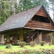
Bonnie Lure State Recreation Area, State recreation area in Clackamas County, United States.

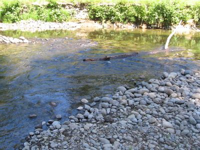
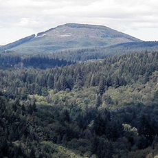
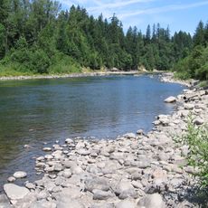
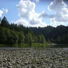
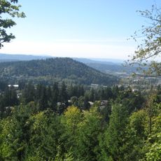
Bonnie Lure State Recreation Area is a protected outdoor space in Clackamas County, Oregon, with Eagle Creek flowing through dense forest. The area provides opportunities for fishing, hiking, and exploring wooded trails.

The land was transferred to the Oregon Parks and Recreation Department in 1976 by The Nature Conservancy. This acquisition was supported by federal conservation funding that helped establish the protected area.

Visitors come here to fish, hike, and observe nature in a forest setting. The place serves as a shared outdoor space where people spend time away from daily routines and connect with the natural world.

The area is open for day visits throughout the year with few seasonal restrictions. Visitors should follow local guidelines about firewood and other resources to help protect the forest ecosystem.

The area protects populations of steelhead trout and pileated woodpeckers that inhabit the forest. Patient observers walking quietly through the trees may spot these animals in their natural habitat.

The community of curious travelers

AroundUs brings together thousands of curated places, local tips, and hidden gems, enriched daily by 60,000 contributors worldwide.

Start exploring
Location
GPS coordinates
45.35210,-122.37700
Latest update
December 13, 2025 12:25
Around this place
Willamette Meteorite
United States of America

Willamette Meteorite

16.2 km
Boring Lava Field
United States of America

Boring Lava Field

11.2 km
Milo McIver State Park
United States of America

Milo McIver State Park

5.1 km
Oxbow Regional Park
United States of America

Oxbow Regional Park

17.4 km
Parents of Murdered Children Memorial
United States of America

Parents of Murdered Children Memorial

16.8 km
Camp Namanu
United States of America

Camp Namanu

15 km
Philip Foster Farm
United States of America

Philip Foster Farm

2 km
United States of America

North Fork Reservoir

15.8 km
Mount Talbert
United States of America

Mount Talbert

16.1 km
Oregon Military Museum
United States of America

Oregon Military Museum

15.7 km
Living Room
United States of America

Living Room

17.2 km
Gresham Carnegie Library
United States of America

Gresham Carnegie Library

17.1 km
Horace Baker Log Cabin
United States of America

Horace Baker Log Cabin

14.5 km
Gresham Library
United States of America

Gresham Library

17 km
Dr. Herbert H. Hughes House
United States of America

Dr. Herbert H. Hughes House

17 km
Haggart Observatory
United States of America

Haggart Observatory

16.1 km
William Gedamke House
United States of America

William Gedamke House

16.5 km
Emanuel and Christina Anderson House
United States of America

Emanuel and Christina Anderson House

15.3 km
William L. Holmes House
United States of America

William L. Holmes House

17.5 km
Charles and Fae Olson House
United States of America

Charles and Fae Olson House

16.1 km
R. S. Smith Motor Company Building
United States of America

R. S. Smith Motor Company Building

10.3 km
Lusted Road Bridge
United States of America

Lusted Road Bridge

14.1 km
Roy E. and Hildur L. Amundsen House
United States of America

Roy E. and Hildur L. Amundsen House

17.3 km
Damascus School
United States of America

Damascus School

9.6 km
North American Bigfoot Center
United States of America

North American Bigfoot Center

9.3 km
Mt. Hood Theatre
United States of America

Mt. Hood Theatre

16.7 km
David and Marianne Ott House
United States of America

David and Marianne Ott House

14.7 km
Mount Hood National Forest Headquarters
United States of America

Mount Hood National Forest Headquarters

8.8 km
Show the full map
« Bonnie Lure State Recreation Area - State recreation area in Clackamas County, United States » is provided by Around Us (aroundus.com). Images and texts are derived from Wikimedia project under a Creative Commons license. You are allowed to copy, distribute, and modify copies of this page, under the conditions set by the license, as long as this note is clearly visible.

Discover hidden gems everywhere you go!

From secret cafés to breathtaking viewpoints, skip the crowded tourist spots and find places that match your style. Our app makes it easy with voice search, smart filtering, route optimization, and insider tips from travelers worldwide. Download now for the complete mobile experience.

Around Us App Screenshot

A unique approach to discovering new places

Le Figaro

All the places worth exploring

France Info

A tailor-made excursion in just a few clicks

20 Minutes

Around Us
Travel Guide & Maps
Download

Send to your phone

QR Code
1

Open the camera app on your mobile.

2

Point at the QR code with your camera. A notification will appear.

3

Tap the notification to open the link.