Enable Location

We need your location to show you interesting places around you

Discover nearby places

Find interesting locations and hidden gems around you

Precise directions

Get accurate directions and distances to places

Your location is never shared with other users. It's only used when you tap the location button.

Mount Baker Tunnel

Log in to your account

Start exploring — it's free

Trusted by 62,111 travelers worldwide

Continue with Google
Continue with Apple
or

We will send you a code to connect

By continuing, you accept our Terms and Conditions and our Privacy Policy

Check your inbox

We've sent a pincode in your inbox. Please enter the code below.

Mount Baker Tunnel, tunnel in Seattle, Washington, USA

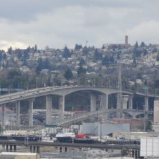
The Mount Baker Tunnel is a road tunnel in Seattle built in 1940 beneath Mount Baker Ridge as part of the original Lake Washington crossing infrastructure. Twin tubes with two lanes each were later expanded with a larger parallel tunnel opened in 1989 to handle growing traffic demands.

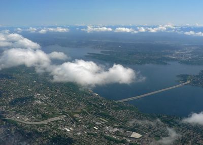
The tunnel opened in 1940 as part of the first Lake Washington crossing project, connecting Seattle to the Eastside and marking a turning point in the city's expansion. More than eleven thousand vehicles used the route on opening day, demonstrating the immediate impact of this transportation link.

The tunnel features decorative concrete portals with symbols of the Pacific Ocean and Asian influences that reflect Seattle's international trading role. These artworks, created through New Deal art projects, blend engineering with cultural expression and mark the entrance as a welcoming gateway to the region.

Vehicles pass through via Interstate 90, with a dedicated walking and biking path running alongside known as the I-90 Trail, the longest of its kind attached to a highway. The tunnels are well lit and regularly maintained, ensuring safe passage for all users.

On opening day, more than eleven thousand vehicles passed through the tunnel in just over ten hours, immediately demonstrating its importance as a city link. Drivers developed a long-standing habit of holding their breath when passing through, especially at the nearby bridges.

The community of curious travelers

AroundUs brings together thousands of curated places, local tips, and hidden gems, enriched daily by 60,000 contributors worldwide.

Start exploring
Location
Official opening
1940
GPS coordinates
47.59030,-122.29900
Latest update
February 7, 2026 11:20
Around this place
Sick's Stadium
United States of America

Sick's Stadium

1.2 km
Starbucks Center
United States of America

Starbucks Center

3 km
West Seattle Bridge
United States of America

West Seattle Bridge

4.4 km
Harbor Island
United States of America

Harbor Island

4.1 km
El Centro de la Raza
United States of America

El Centro de la Raza

1.4 km
Spokane Street Bridge
United States of America

Spokane Street Bridge

4.6 km
Hat 'n' Boots
United States of America

Hat 'n' Boots

5.3 km
Georgetown Steam Plant
United States of America

Georgetown Steam Plant

5.4 km
Coast Guard Museum Northwest
United States of America

Coast Guard Museum Northwest

2.9 km
Connections Museum
United States of America

Connections Museum

5.8 km
Lady Rainier
United States of America

Lady Rainier

2.2 km
First Avenue South Bridge
United States of America

First Avenue South Bridge

6 km
Dai Bai Zan Cho Bo Zen Ji
United States of America

Dai Bai Zan Cho Bo Zen Ji

2 km
South Park Bridge
United States of America

South Park Bridge

6.9 km
Oxbow Park
United States of America

Oxbow Park

5.3 km
Marra Farm
United States of America

Marra Farm

7.9 km
Living Computers: Museum + Labs
United States of America

Living Computers: Museum + Labs

2.8 km
Frank B. Cooper School
United States of America

Frank B. Cooper School

5.4 km
Center Park
United States of America

Center Park

679 m
Beacon Hill Branch Library
United States of America

Beacon Hill Branch Library

1.7 km
Old Georgetown City Hall
United States of America

Old Georgetown City Hall

4.9 km
Fifth Church of Christ, Scientist
United States of America

Fifth Church of Christ, Scientist

3.4 km
Sixth Church of Christ, Scientist
United States of America

Sixth Church of Christ, Scientist

6.6 km
Columbia City Historic District
United States of America

Columbia City Historic District

3.6 km
Lowman Beach
United States of America

Lowman Beach

9.3 km
Columbia City Theater
United States of America

Columbia City Theater

3.8 km
Driftwood Sculpture Walk, Lincoln Park, West Seattle
United States of America

Driftwood Sculpture Walk, Lincoln Park, West Seattle

9.5 km
Kenyon Hall
United States of America

Kenyon Hall

8.7 km
Show the full map
« Mount Baker Tunnel - tunnel in Seattle, Washington, USA » is provided by Around Us (aroundus.com). Images and texts are derived from Wikimedia project under a Creative Commons license. You are allowed to copy, distribute, and modify copies of this page, under the conditions set by the license, as long as this note is clearly visible.

Discover hidden gems everywhere you go!

From secret cafés to breathtaking viewpoints, skip the crowded tourist spots and find places that match your style. Our app makes it easy with voice search, smart filtering, route optimization, and insider tips from travelers worldwide. Download now for the complete mobile experience.

Around Us App Screenshot

A unique approach to discovering new places

Le Figaro

All the places worth exploring

France Info

A tailor-made excursion in just a few clicks

20 Minutes

Around Us
Travel Guide & Maps
Download

Send to your phone

QR Code
1

Open the camera app on your mobile.

2

Point at the QR code with your camera. A notification will appear.

3

Tap the notification to open the link.