Chest opened
+${chestReward.xp} XP
Explorer
NOUVEAU ×${chestReward.collectible.quantity}
tapez pour fermer
Chest locked

Open chests in the app

Around Us is built for your phone — chests unlock when you walk, explore and capture nearby places.

Enable Location

We need your location to show you interesting places around you

Discover nearby places

Find interesting locations and hidden gems around you

Precise directions

Get accurate directions and distances to places

Your location is never shared with other users. It's only used when you tap the location button.

Log in to your account

Start exploring — it's free

Trusted by 72,975 travelers worldwide

Continue with Google
Continue with Apple
or

We will send you a code to connect

By continuing, you accept our Terms and Conditions and our Privacy Policy

Check your inbox

We've sent a pincode in your inbox. Please enter the code below.

Dick Smith Wilderness
Discussion Reviews Photo
4.6k Popularity

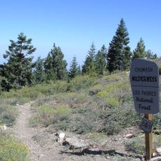
Dick Smith Wilderness, Protected wilderness area in Los Padres National Forest, California, US.

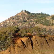
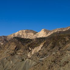
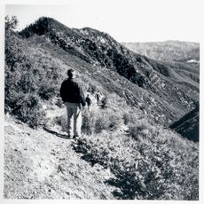
Dick Smith Wilderness is a protected natural area in the Los Padres Mountains along the border between Santa Barbara and Ventura counties. The terrain rises from deep valleys to the Madulce Peak summit and is crossed by several hiking trails.

The area was officially protected in 1984 through the California Wilderness Act and named after Dick Smith, an environmental journalist with the Santa Barbara News-Press. The name honors his work advocating for this landscape.

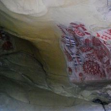
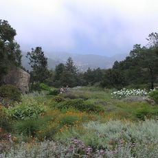
This land was home to the Chumash people for thousands of years, and they left spiritual sites throughout the area. Visitors can sometimes spot signs of this deep connection to the land at various locations.

Access is by foot only, and hikers should bring paper maps and stay on marked trails. Motorized vehicles and mechanical equipment are not permitted, so proper preparation is essential.

A large fire in 2007 altered the vegetation, and today the area serves as a flight corridor for California condors. These rare birds use the higher elevations while traveling between distant sanctuaries.

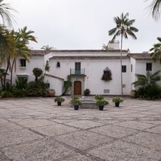
The community of curious travelers

AroundUs brings together thousands of curated places, local tips, and hidden gems, enriched daily by 60,000 contributors worldwide.

Start exploring
Location
GPS coordinates
34.66670,-119.50000
Latest update
December 10, 2025 20:07
Around this place
Mission Santa Barbara
United States of America

Mission Santa Barbara

32.1 km
El Fureidis
United States of America

El Fureidis

28.6 km
Knapp's Castle
United States of America

Knapp's Castle

31.2 km
Lotusland
United States of America

Lotusland

28.8 km
Santa Barbara Bowl
United States of America

Santa Barbara Bowl

31.5 km
Chumash Painted Cave State Historic Park
United States of America

Chumash Painted Cave State Historic Park

32 km
Santa Barbara Zoo
United States of America

Santa Barbara Zoo

31.4 km
Carpinteria State Beach
United States of America

Carpinteria State Beach

30.7 km
Santa Barbara Museum of Natural History
United States of America

Santa Barbara Museum of Natural History

31.9 km
Casa del Herrero
United States of America

Casa del Herrero

28.6 km
Santa Barbara Botanic Garden
United States of America

Santa Barbara Botanic Garden

30.5 km
Carpinteria State Beach
United States of America

Carpinteria State Beach

30.7 km
Chumash Wilderness
United States of America

Chumash Wilderness

30.7 km
Santa Barbara Vedanta Temple
United States of America

Santa Barbara Vedanta Temple

25.7 km
Gibraltar Dam
United States of America

Gibraltar Dam

23.1 km
Rafael Gonzalez House
United States of America

Rafael Gonzalez House

32.4 km
Charles M. Pratt House
United States of America

Charles M. Pratt House

32 km
East Beach
United States of America

East Beach

32.6 km
La Cumbre Peak
United States of America

La Cumbre Peak

27.3 km
Big Caliente Hot Springs
United States of America

Big Caliente Hot Springs

15.4 km
Shalawa Meadow, California
United States of America

Shalawa Meadow, California

30.5 km
Santa Barbara Mission-Archive Library
United States of America

Santa Barbara Mission-Archive Library

32.1 km
Acacia Lodge
United States of America

Acacia Lodge

29.6 km
Little Pine Mountain
United States of America

Little Pine Mountain

23.1 km
Madulce Peak
United States of America

Madulce Peak

8.8 km
Santa Claus Beach
United States of America

Santa Claus Beach

29.2 km
Summerland Beach
United States of America

Summerland Beach

29 km
Rocky Nook Park
United States of America

Rocky Nook Park

31.5 km
Show the full map
Reviews
Share your experience

No review yet

Discussions
Start a discussion...

No discussion yet

« Dick Smith Wilderness - Protected wilderness area in Los Padres National Forest, California, US » is provided by Around Us (aroundus.com). Images and texts are derived from Wikimedia project under a Creative Commons license. You are allowed to copy, distribute, and modify copies of this page, under the conditions set by the license, as long as this note is clearly visible.

Discover hidden gems everywhere you go!

From secret cafés to breathtaking viewpoints, skip the crowded tourist spots and find places that match your style. Our app makes it easy with voice search, smart filtering, route optimization, and insider tips from travelers worldwide. Download now for the complete mobile experience.

Around Us App Screenshot

A unique approach to discovering new places

Le Figaro

All the places worth exploring

France Info

A tailor-made excursion in just a few clicks

20 Minutes

Around Us
Travel Guide & Maps
Download

Send to your phone

QR Code
1

Open the camera app on your mobile.

2

Point at the QR code with your camera. A notification will appear.

3

Tap the notification to open the link.