Enable Location

We need your location to show you interesting places around you

Discover nearby places

Find interesting locations and hidden gems around you

Precise directions

Get accurate directions and distances to places

Your location is never shared with other users. It's only used when you tap the location button.

Merced Grove Ranger Station

Log in to your account

Start exploring — it's free

Trusted by 62,425 travelers worldwide

Continue with Google
Continue with Apple
or

We will send you a code to connect

By continuing, you accept our Terms and Conditions and our Privacy Policy

Check your inbox

We've sent a pincode in your inbox. Please enter the code below.

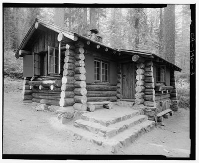
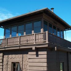
Merced Grove Ranger Station, building in California, United States

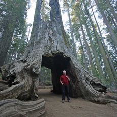
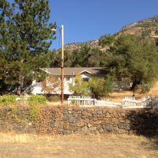
The Merced Grove Ranger Station is a log cabin in Yosemite National Park, built near a small forest of giant sequoias. The modest structure contains a living room, bedroom, and kitchen, with two small outdoor toilets situated on a nearby slope.

Built between 1934 and 1935 by the National Park Service, the station replaced an earlier checkpoint established in 1915 on Coulterville Road. It was designed to serve park rangers and visitors in the region around the giant sequoias.

The station takes its name from the nearby Merced Grove, a small forest of giant sequoias in the area. Its simple log construction reflects how early park staff chose to build in harmony with the natural surroundings, and visitors notice this modest approach as part of how the park was managed.

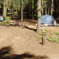
The building sits near the trail to the grove and can be easily spotted along the hiking route. Dogs are not permitted on the trails in this area, so visitors with pets should plan to explore other parts of the park instead.

Superintendent Carl Russell used the station as a quiet retreat while writing about Yosemite's history. This intimate workspace away from busier park areas shows how staff members used the place for reflection and written work.

The community of curious travelers

AroundUs brings together thousands of curated places, local tips, and hidden gems, enriched daily by 60,000 contributors worldwide.

Start exploring
Location
Inception
1930s
Architects
National Park Service
Architectural style
rustic architecture
Made from material
log
GPS coordinates
37.74909,-119.84006
Latest update
February 9, 2026 07:40
Around this place
The Nose
United States of America

The Nose

18 km
Tunnel View
United States of America

Tunnel View

14.8 km
Ribbon Fall
United States of America

Ribbon Fall

17 km
Ferguson landslide
United States of America

Ferguson landslide

11.6 km
Crane Flat Campground
United States of America

Crane Flat Campground

3.5 km
Middle Cathedral Rock
United States of America

Middle Cathedral Rock

18.2 km
Silver Strand Falls
United States of America

Silver Strand Falls

15.8 km
Crane Flat Fire Lookout
United States of America

Crane Flat Fire Lookout

2.1 km
Hetch Hetchy Railroad 6
United States of America

Hetch Hetchy Railroad 6

9.6 km
Henness Ridge Fire Lookout
United States of America

Henness Ridge Fire Lookout

16.1 km
Tamarack Flat Campground
United States of America

Tamarack Flat Campground

9.1 km
McCauley and Meyer Barns
United States of America

McCauley and Meyer Barns

9.4 km
Bagby Stationhouse, Water Tanks and Turntable
United States of America

Bagby Stationhouse, Water Tanks and Turntable

9.6 km
Dead Giant Tunnel Tree
United States of America

Dead Giant Tunnel Tree

3.7 km
Crane Flat
United States of America

Crane Flat

1.7 km
Pohono Bridge
United States of America

Pohono Bridge

15.7 km
Tamarack Flat
United States of America

Tamarack Flat

9 km
South Fork Tuolumne River Bridge
United States of America

South Fork Tuolumne River Bridge

11.4 km
Bower Cave
United States of America

Bower Cave

17.2 km
Dewey Point
United States of America

Dewey Point

17.3 km
Yosemite Valley Railroad Caboose No. 15
United States of America

Yosemite Valley Railroad Caboose No. 15

9.6 km
El Portal Old Schoolhouse
United States of America

El Portal Old Schoolhouse

9.5 km
Arch Rock
United States of America

Arch Rock

11.9 km
Arch Rock Entrance Station
United States of America

Arch Rock Entrance Station

11.9 km
South Fork Tuolumne River Bridge
United States of America

South Fork Tuolumne River Bridge

17.4 km
Wildcat Creek Bridge
United States of America

Wildcat Creek Bridge

11.1 km
Tamarack Creek Bridge
United States of America

Tamarack Creek Bridge

11.3 km
Cascade Creek Bridge
United States of America

Cascade Creek Bridge

11.4 km
Show the full map
« Merced Grove Ranger Station - building in California, United States » is provided by Around Us (aroundus.com). Images and texts are derived from Wikimedia project under a Creative Commons license. You are allowed to copy, distribute, and modify copies of this page, under the conditions set by the license, as long as this note is clearly visible.

Discover hidden gems everywhere you go!

From secret cafés to breathtaking viewpoints, skip the crowded tourist spots and find places that match your style. Our app makes it easy with voice search, smart filtering, route optimization, and insider tips from travelers worldwide. Download now for the complete mobile experience.

Around Us App Screenshot

A unique approach to discovering new places

Le Figaro

All the places worth exploring

France Info

A tailor-made excursion in just a few clicks

20 Minutes

Around Us
Travel Guide & Maps
Download

Send to your phone

QR Code
1

Open the camera app on your mobile.

2

Point at the QR code with your camera. A notification will appear.

3

Tap the notification to open the link.