Enable Location

We need your location to show you interesting places around you

Discover nearby places

Find interesting locations and hidden gems around you

Precise directions

Get accurate directions and distances to places

Your location is never shared with other users. It's only used when you tap the location button.

Arc Dome Wilderness

Log in to your account

Start exploring — it's free

Trusted by 61,587 travelers worldwide

Continue with Google
Continue with Apple
or

We will send you a code to connect

By continuing, you accept our Terms and Conditions and our Privacy Policy

Check your inbox

We've sent a pincode in your inbox. Please enter the code below.

Arc Dome Wilderness

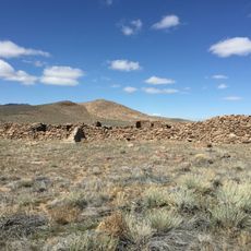
Arc Dome Wilderness, Protected wilderness area in Nye County, Nevada, United States

Description

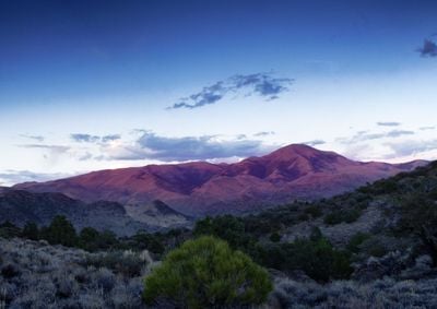
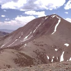
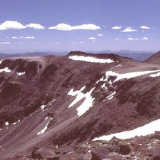
Arc Dome Wilderness is a protected region spanning approximately 115,000 acres across the Toiyabe Range, with mountain peaks, valleys, and distinct ecological zones at different elevations. The terrain rises across considerable elevation changes and displays shifting habitats ranging from dry sagebrush areas to forested slopes.

History

The area received protection from the United States Congress in 1989 and became part of the Humboldt-Toiyabe National Forest system. This designation reflects a growing recognition of the importance of undeveloped mountain landscapes for nature conservation and recreation.

Culture

The Toiyabe Crest Trail runs through this area and connects walkers to routes shaped by generations of outdoor enthusiasts. These paths remain central to how visitors experience and understand the mountain landscape today.

Practical

Visitors should bring sufficient water, navigation tools, and emergency supplies because this area lacks developed facilities or marked trails. Proper preparation is essential when traveling through this undeveloped terrain.

Did you know?

Birds such as the northern goshawk and sagebrush sparrow inhabit this protected area, making it important for watching these species in their natural setting. The Columbia spotted frog occupies water zones throughout the territory and adds to the region's animal diversity.

Location
Inception
1989
GPS coordinates
38.80330,-117.32300
Latest update
December 12, 2025 14:24

AroundUs brings together thousands of curated places, local tips, and hidden gems, enriched daily by 60,000 contributors worldwide. Discover all places nearby (Nevada).

Around this place
Berlin Historic District
United States of America

Berlin Historic District

26.2 km
Sand Mountain
United States of America

Sand Mountain

108.6 km
Berlin–Ichthyosaur State Park
United States of America

Berlin–Ichthyosaur State Park

25 km
Stokes Castle
United States of America

Stokes Castle

79.7 km
Arc Dome
United States of America

Arc Dome

4.2 km
Hawthorne Ordnance Museum
United States of America

Hawthorne Ordnance Museum

117.1 km
Belmont Courthouse State Historic Park
United States of America

Belmont Courthouse State Historic Park

45.2 km
Alta Toquima Wilderness
United States of America

Alta Toquima Wilderness

34.7 km
McGinness Hills Geothermal Complex
United States of America

McGinness Hills Geothermal Complex

94.4 km
Toquima Cave
United States of America

Toquima Cave

63 km
Cold Springs Pony Express Station Ruins
United States of America

Cold Springs Pony Express Station Ruins

79.9 km
George A. Bartlett House
United States of America

George A. Bartlett House

82.3 km
Nye County Courthouse
United States of America

Nye County Courthouse

82.5 km
Cold Springs Station Site
United States of America

Cold Springs Station Site

79.9 km
Mineral County Museum
United States of America

Mineral County Museum

117.1 km
State Bank and Trust Company Building
United States of America

State Bank and Trust Company Building

82.3 km
Sixth Street School
United States of America

Sixth Street School

116.9 km
Austin Masonic and Odd Fellows Hall
United States of America

Austin Masonic and Odd Fellows Hall

79.8 km
Lander County Courthouse
United States of America

Lander County Courthouse

79.7 km
Austin City Hall
United States of America

Austin City Hall

79.7 km
Tonopah Historic Mining Park
United States of America

Tonopah Historic Mining Park

82.2 km
St. Mark's Episcopal Church
United States of America

St. Mark's Episcopal Church

82.5 km
Mineral County Courthouse
United States of America

Mineral County Courthouse

117.2 km
Austin Historic District
United States of America

Austin Historic District

79.9 km
E.R. Shields House
United States of America

E.R. Shields House

82.5 km
John Gregovich House
United States of America

John Gregovich House

82.3 km
Judge W.A. Sawle House
United States of America

Judge W.A. Sawle House

82.3 km
Uri B. Curtis House
United States of America

Uri B. Curtis House

82.5 km
Show the full map
« Arc Dome Wilderness - Protected wilderness area in Nye County, Nevada, United States » is provided by Around Us (aroundus.com). Images and texts are derived from Wikimedia project under a Creative Commons license. You are allowed to copy, distribute, and modify copies of this page, under the conditions set by the license, as long as this note is clearly visible.

Discover hidden gems everywhere you go!

From secret cafés to breathtaking viewpoints, skip the crowded tourist spots and find places that match your style. Our app makes it easy with voice search, smart filtering, route optimization, and insider tips from travelers worldwide. Download now for the complete mobile experience.

Around Us App Screenshot

A unique approach to discovering new places

Le Figaro

All the places worth exploring

France Info

A tailor-made excursion in just a few clicks

20 Minutes

Around Us
Travel Guide & Maps
Download

Send to your phone

QR Code
1

Open the camera app on your mobile.

2

Point at the QR code with your camera. A notification will appear.

3

Tap the notification to open the link.