Enable Location

We need your location to show you interesting places around you

Discover nearby places

Find interesting locations and hidden gems around you

Precise directions

Get accurate directions and distances to places

Your location is never shared with other users. It's only used when you tap the location button.

Dominguez Canyon Wilderness

Log in to your account

Start exploring — it's free

Trusted by 62,188 travelers worldwide

Continue with Google
Continue with Apple
or

We will send you a code to connect

By continuing, you accept our Terms and Conditions and our Privacy Policy

Check your inbox

We've sent a pincode in your inbox. Please enter the code below.

Dominguez Canyon Wilderness

Dominguez Canyon Wilderness, Protected wilderness area in western Colorado, United States.

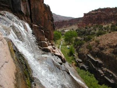
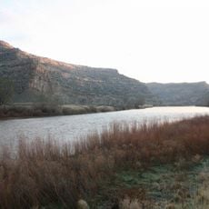
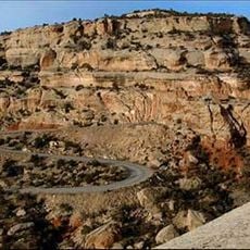
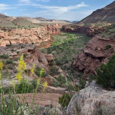
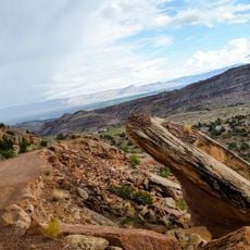
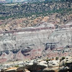
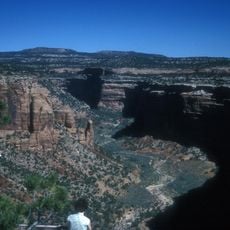
Dominguez Canyon Wilderness is a protected area of red sandstone canyons, cascading waterfalls, and desert terrain spread across several counties. The landscape contains two major canyon systems cut deep into rock, with varying elevations that create different habitats and plant communities throughout.

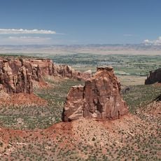
Congress established this protected wilderness in 2009, making it the largest undeveloped Bureau of Land Management territory of its kind in Colorado. This designation recognized the need to keep the landscape intact and free from roads.

Native American petroglyphs mark the canyon walls and reflect the long presence of Ute peoples in this land. Visitors walking through the canyons today can still see these ancient marks left by those who knew these places well.

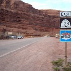
The area has marked trails starting from different access points near Grand Junction, making it straightforward to find where to begin exploring. Visit in spring or fall for cooler weather that makes hiking more comfortable, though the site welcomes visitors year-round.

The entire area remains completely free of roads and developed infrastructure, making it one of the largest unbroken stretches of wild landscape in the region. This isolation lets visitors fully escape from modern construction and engineering.

The community of curious travelers

AroundUs brings together thousands of curated places, local tips, and hidden gems, enriched daily by 60,000 contributors worldwide.

Start exploring
Location
Location
Location
Inception
2009
GPS coordinates
38.75000,-108.41700
Latest update
December 10, 2025 20:05
Around this place
Colorado National Monument
United States of America

Colorado National Monument

40 km
James M. Robb – Colorado River State Park
United States of America

James M. Robb – Colorado River State Park

34.4 km
Egyptian Theatre
United States of America

Egyptian Theatre

30.2 km
Rim Rock Drive
United States of America

Rim Rock Drive

41 km
Ralph Stocker Stadium
United States of America

Ralph Stocker Stadium

38.2 km
Land's End Observatory
United States of America

Land's End Observatory

34.9 km
Dominguez-Escalante National Conservation Area
United States of America

Dominguez-Escalante National Conservation Area

2.4 km
Serpents Trail
United States of America

Serpents Trail

36.6 km
Western Colorado Center for the Arts
United States of America

Western Colorado Center for the Arts

39.2 km
Mesa County Public Library District
United States of America

Mesa County Public Library District

37.9 km
Cross Orchards Historic Site
United States of America

Cross Orchards Historic Site

38.4 km
Devils Kitchen Picnic Shelter
United States of America

Devils Kitchen Picnic Shelter

36.7 km
Clifton Community Center and Church
United States of America

Clifton Community Center and Church

38.1 km
First Methodist Episcopal Church of Delta
United States of America

First Methodist Episcopal Church of Delta

30.2 km
First Presbyterian Church of Eckert
United States of America

First Presbyterian Church of Eckert

39.7 km
Handy Chapel
United States of America

Handy Chapel

37.9 km
Delta County Bank Building
United States of America

Delta County Bank Building

30.1 km
Dinosaur Diamond Prehistoric Highway
United States of America

Dinosaur Diamond Prehistoric Highway

38.1 km
North Seventh Street Historic Residential District
United States of America

North Seventh Street Historic Residential District

37.9 km
Garnethurst
United States of America

Garnethurst

30.8 km
No Thoroughfare Canyon
United States of America

No Thoroughfare Canyon

37.8 km
Ute Canyon
United States of America

Ute Canyon

40 km
The Art Center
United States of America

The Art Center

39.2 km
Avalon Theatre
United States of America

Avalon Theatre

37.4 km
Graff Dairy
United States of America

Graff Dairy

38.6 km
Mesa Theater
United States of America

Mesa Theater

37.6 km
Mesa County Public Library District - Central Library
United States of America

Mesa County Public Library District - Central Library

37.9 km
East Tunnel
United States of America

East Tunnel

37.2 km
Show the full map
« Dominguez Canyon Wilderness - Protected wilderness area in western Colorado, United States » is provided by Around Us (aroundus.com). Images and texts are derived from Wikimedia project under a Creative Commons license. You are allowed to copy, distribute, and modify copies of this page, under the conditions set by the license, as long as this note is clearly visible.

Discover hidden gems everywhere you go!

From secret cafés to breathtaking viewpoints, skip the crowded tourist spots and find places that match your style. Our app makes it easy with voice search, smart filtering, route optimization, and insider tips from travelers worldwide. Download now for the complete mobile experience.

Around Us App Screenshot

A unique approach to discovering new places

Le Figaro

All the places worth exploring

France Info

A tailor-made excursion in just a few clicks

20 Minutes

Around Us
Travel Guide & Maps
Download

Send to your phone

QR Code
1

Open the camera app on your mobile.

2

Point at the QR code with your camera. A notification will appear.

3

Tap the notification to open the link.