Enable Location

We need your location to show you interesting places around you

Discover nearby places

Find interesting locations and hidden gems around you

Precise directions

Get accurate directions and distances to places

Your location is never shared with other users. It's only used when you tap the location button.

Log in to your account

Start exploring — it's free

Trusted by 61,771 travelers worldwide

Continue with Google
Continue with Apple
or

We will send you a code to connect

By continuing, you accept our Terms and Conditions and our Privacy Policy

Check your inbox

We've sent a pincode in your inbox. Please enter the code below.

Mantle's Cave, Archaeological cave in Moffat County, Colorado, US.

Description

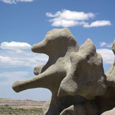
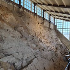
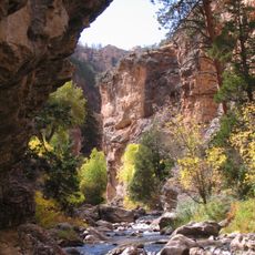
Mantle's Cave is a rock shelter located within Dinosaur National Monument in Moffat County, Colorado, positioned on a north-facing slope above the Yampa River. The formation contains multiple chambers and sections that reveal evidence of human occupation spanning several centuries.

History

Scientific excavation in 1939 first revealed the cave's extensive use from around 550 to 1000 AD by indigenous peoples. The investigation uncovered cultural layers and artifacts that documented how communities in the region managed their survival over many generations.

Culture

The cave served as a storage hub for the Uinta-Fremont people who lived in this region centuries ago. Visitors can see how this community organized its daily resources and what mattered most to them through what was left behind.

Practical

Access to the cave is carefully controlled and requires advance permission from local authorities due to its protected status. Plan your visit well ahead and contact the appropriate agency to understand current conditions and any restrictions for entry.

Did you know?

Within the cave are remnants of 50 distinct storage pits, each containing different types of preserved goods from ancient times. This arrangement reveals how carefully the inhabitants managed their supplies, separating foods and materials for organized survival.

Location
GPS coordinates
40.46670,-108.90100
Latest update
December 12, 2025 16:42

AroundUs brings together thousands of curated places, local tips, and hidden gems, enriched daily by 60,000 contributors worldwide. Discover all places nearby (Moffat County).

Around this place
Skinwalker Ranch
United States of America

Skinwalker Ranch

86.9 km
Morrison Formation
United States of America

Morrison Formation

34 km
Flaming Gorge Dam
United States of America

Flaming Gorge Dam

66.4 km
Flaming Gorge National Recreation Area
United States of America

Flaming Gorge National Recreation Area

66.4 km
Fantasy Canyon
United States of America

Fantasy Canyon

62.1 km
Red Fleet State Park
United States of America

Red Fleet State Park

46.8 km
Josie Bassett Morris Ranch Complex
United States of America

Josie Bassett Morris Ranch Complex

23.6 km
Steinaker State Park
United States of America

Steinaker State Park

53.5 km
Quarry Visitor Center
United States of America

Quarry Visitor Center

34 km
Ouray National Wildlife Refuge
United States of America

Ouray National Wildlife Refuge

67 km
Utah Field House of Natural History State Park Museum
United States of America

Utah Field House of Natural History State Park Museum

52.4 km
Dinah the Pink Dinosaur
United States of America

Dinah the Pink Dinosaur

51.7 km
Quarry Exhibit Hall
United States of America

Quarry Exhibit Hall

34 km
Rial Chew Ranch Complex
United States of America

Rial Chew Ranch Complex

10.1 km
Utah Field House of Natural History State Park Museum
United States of America

Utah Field House of Natural History State Park Museum

52.4 km
Old Ladore School
United States of America

Old Ladore School

34.9 km
Upper Wade and Curtis Cabin
United States of America

Upper Wade and Curtis Cabin

29.1 km
Ute Mountain Fire Tower
United States of America

Ute Mountain Fire Tower

87.7 km
Swett Ranch
United States of America

Swett Ranch

67.6 km
Earl Douglass Workshop-Laboratory
United States of America

Earl Douglass Workshop-Laboratory

34 km
Lewis Curry House
United States of America

Lewis Curry House

53.1 km
Manfred and Ethel Martin House
United States of America

Manfred and Ethel Martin House

53.1 km
St. Paul's Episcopal Church and Lodge
United States of America

St. Paul's Episcopal Church and Lodge

53.5 km
Gibson-Sowards House
United States of America

Gibson-Sowards House

53.7 km
Hay's Ranch Bridge
United States of America

Hay's Ranch Bridge

85.3 km
Vernal Tithing Office
United States of America

Vernal Tithing Office

54 km
Moonshine Arch
United States of America

Moonshine Arch

55.5 km
Hole in the Wall Canyon
United States of America

Hole in the Wall Canyon

51.7 km
Show the full map
« Mantle's Cave - Archaeological cave in Moffat County, Colorado, US » is provided by Around Us (aroundus.com). Images and texts are derived from Wikimedia project under a Creative Commons license. You are allowed to copy, distribute, and modify copies of this page, under the conditions set by the license, as long as this note is clearly visible.

Discover hidden gems everywhere you go!

From secret cafés to breathtaking viewpoints, skip the crowded tourist spots and find places that match your style. Our app makes it easy with voice search, smart filtering, route optimization, and insider tips from travelers worldwide. Download now for the complete mobile experience.

Around Us App Screenshot

A unique approach to discovering new places

Le Figaro

All the places worth exploring

France Info

A tailor-made excursion in just a few clicks

20 Minutes

Around Us
Travel Guide & Maps
Download

Send to your phone

QR Code
1

Open the camera app on your mobile.

2

Point at the QR code with your camera. A notification will appear.

3

Tap the notification to open the link.