Enable Location

We need your location to show you interesting places around you

Discover nearby places

Find interesting locations and hidden gems around you

Precise directions

Get accurate directions and distances to places

Your location is never shared with other users. It's only used when you tap the location button.

Fish Creek Falls

Log in to your account

Start exploring — it's free

Trusted by 61,595 travelers worldwide

Continue with Google
Continue with Apple
or

We will send you a code to connect

By continuing, you accept our Terms and Conditions and our Privacy Policy

Check your inbox

We've sent a pincode in your inbox. Please enter the code below.

Fish Creek Falls

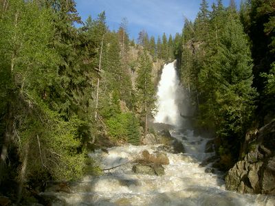
Fish Creek Falls, Waterfall in Routt National Forest, Colorado, United States.

Description

Fish Creek Falls is a waterfall in Routt National Forest, Colorado, that plunges roughly 86 meters through a glacial valley, forming a powerful cascade. Multiple viewing platforms positioned along maintained trails allow visitors to observe the falls from different angles and distances.

History

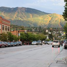
Native American tribes used the area around the falls for centuries, relying on its water resources and landscape for sustenance and daily life. The region later became part of the protected Routt National Forest, making the falls accessible to the public for recreation.

Culture

The waterfall serves as a gathering spot where visitors of all ages come to experience the raw power of flowing water through hiking or winter ice climbing activities. People from the area and beyond visit regularly to connect with the landscape and test themselves against the natural elements.

Practical

The falls are reached via a short paved path from the parking area and can be walked comfortably by most people. Weather conditions change quickly in the mountains, so visitors should bring layers and be prepared for sudden shifts in temperature or precipitation.

Did you know?

Winter transforms the falls into a frozen vertical column of ice that draws experienced climbers who scale its slick surface as a technical sport. This seasonal change creates a completely different experience than the cascading water seen during warmer months.

GPS coordinates
40.48145,-106.77144
Latest update
December 8, 2025 20:02

AroundUs brings together thousands of curated places, local tips, and hidden gems, enriched daily by 60,000 contributors worldwide. Discover all places nearby (United States of America).

Around this place
Flat Top Mountain
United States of America

Flat Top Mountain

58.3 km
State Forest State Park
United States of America

State Forest State Park

64.5 km
United States of America

Gore Canyon

59.1 km
Pearl Lake State Park
United States of America

Pearl Lake State Park

35.4 km
Mount Werner
United States of America

Mount Werner

3.9 km
Steamboat Lake State Park
United States of America

Steamboat Lake State Park

39.5 km
Stagecoach State Park
United States of America

Stagecoach State Park

22.8 km
Mount Zirkel Wilderness
United States of America

Mount Zirkel Wilderness

30.4 km
Yampa River State Park
United States of America

Yampa River State Park

45.9 km
Arapaho National Wildlife Refuge
United States of America

Arapaho National Wildlife Refuge

44.9 km
Mount Zirkel
United States of America

Mount Zirkel

40.1 km
Wolford Mountain Reservoir
United States of America

Wolford Mountain Reservoir

51 km
Parkview Mountain
United States of America

Parkview Mountain

56.4 km
Crawford House
United States of America

Crawford House

5.7 km
Elkhead State Park
United States of America

Elkhead State Park

52.4 km
Stagecoach Dam
United States of America

Stagecoach Dam

22.4 km
Elkhead Reservoir
United States of America

Elkhead Reservoir

52.1 km
Waterwheel
United States of America

Waterwheel

64.6 km
Christian Science Society
United States of America

Christian Science Society

5.1 km
Museum of Northwest Colorado
United States of America

Museum of Northwest Colorado

65.8 km
Chamber of Commerce Building (Steamboat Springs, Colorado)
United States of America

Chamber of Commerce Building (Steamboat Springs, Colorado)

5.8 km
First National Bank Building
United States of America

First National Bank Building

5.4 km
Vanatta Apartments
United States of America

Vanatta Apartments

65.8 km
First National Bank Building
United States of America

First National Bank Building

65.7 km
Hayden Rooming House
United States of America

Hayden Rooming House

41.3 km
Chief Theatre
United States of America

Chief Theatre

5.4 km
Park Theater
United States of America

Park Theater

49.8 km
Hahns Peak Lookout
United States of America

Hahns Peak Lookout

42.4 km
Show the full map
« Fish Creek Falls - Waterfall in Routt National Forest, Colorado, United States » is provided by Around Us (aroundus.com). Images and texts are derived from Wikimedia project under a Creative Commons license. You are allowed to copy, distribute, and modify copies of this page, under the conditions set by the license, as long as this note is clearly visible.

Discover hidden gems everywhere you go!

From secret cafés to breathtaking viewpoints, skip the crowded tourist spots and find places that match your style. Our app makes it easy with voice search, smart filtering, route optimization, and insider tips from travelers worldwide. Download now for the complete mobile experience.

Around Us App Screenshot

A unique approach to discovering new places

Le Figaro

All the places worth exploring

France Info

A tailor-made excursion in just a few clicks

20 Minutes

Around Us
Travel Guide & Maps
Download

Send to your phone

QR Code
1

Open the camera app on your mobile.

2

Point at the QR code with your camera. A notification will appear.

3

Tap the notification to open the link.