Enable Location

We need your location to show you interesting places around you

Discover nearby places

Find interesting locations and hidden gems around you

Precise directions

Get accurate directions and distances to places

Your location is never shared with other users. It's only used when you tap the location button.

Cherry Creek Bridge

Log in to your account

Start exploring — it's free

Trusted by 62,192 travelers worldwide

Continue with Google
Continue with Apple
or

We will send you a code to connect

By continuing, you accept our Terms and Conditions and our Privacy Policy

Check your inbox

We've sent a pincode in your inbox. Please enter the code below.

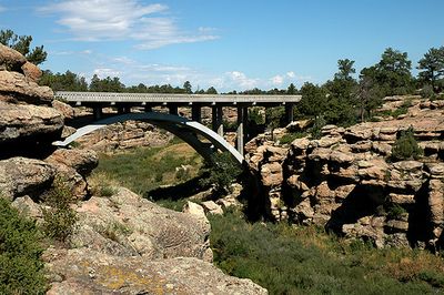
Cherry Creek Bridge, Concrete arch bridge in Franktown, Colorado.

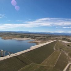
Cherry Creek Bridge is a concrete arch bridge that crosses a waterway valley with a distinctive two-rib open-spandrel design. The structure spans across the landscape with a relatively narrow width, making it efficient for vehicle passage through the area.

The structure was built after World War II and represents the concrete construction methods developed during that era in Colorado. Its recognition as a historic place came decades later, marking its importance in the region's engineering history.

The bridge represents post-war engineering practices in Colorado, departing from the standard lighter concrete designs common during that period.

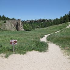
The bridge can be seen from the main highway passing through the area, making it easy to observe during a drive through the valley. Best viewing comes from crossing it directly or from nearby park access points along the route.

The longest single span of this structure was unusually impressive for its construction period and demonstrates the technical capabilities of post-war engineers in Colorado. Visitors often miss this engineering achievement despite its significance in local construction history.

The community of curious travelers

AroundUs brings together thousands of curated places, local tips, and hidden gems, enriched daily by 60,000 contributors worldwide.

Start exploring
Location
GPS coordinates
39.32810,-104.73400
Latest update
December 14, 2025 11:05
Around this place
Castlewood Canyon State Park
United States of America

Castlewood Canyon State Park

466 m
Roxborough State Park
United States of America

Roxborough State Park

31 km
Devil's Head Lookout
United States of America

Devil's Head Lookout

32.5 km
Colorado Piedmont
United States of America

Colorado Piedmont

14 km
Denver Colorado Temple
United States of America

Denver Colorado Temple

33.4 km
Aurora Reservoir
United States of America

Aurora Reservoir

33 km
Castle Rock
United States of America

Castle Rock

11.9 km
Devils Head
United States of America

Devils Head

32.5 km
Rueter-Hess Reservoir
United States of America

Rueter-Hess Reservoir

19.5 km
Tri-Lakes, Colorado
United States of America

Tri-Lakes, Colorado

28 km
Dawson Butte
United States of America

Dawson Butte

17.8 km
Cherokee Ranch
United States of America

Cherokee Ranch

22.8 km
Seventeen Mile House
United States of America

Seventeen Mile House

27.1 km
Ridgeline Open Space
United States of America

Ridgeline Open Space

15.6 km
Pike's Peak Grange No. 163
United States of America

Pike's Peak Grange No. 163

9.3 km
Castle Rock Depot
United States of America

Castle Rock Depot

12.2 km
St. Mark United Presbyterian Church
United States of America

St. Mark United Presbyterian Church

20.8 km
J.G. Evans Barn
United States of America

J.G. Evans Barn

28.8 km
Church of St. Philip-in-the-Field and Bear Canon Cemetery
United States of America

Church of St. Philip-in-the-Field and Bear Canon Cemetery

19.9 km
Ruth Memorial Methodist Episcopal Church
United States of America

Ruth Memorial Methodist Episcopal Church

21.3 km
Reginald Sinclaire House
United States of America

Reginald Sinclaire House

18.7 km
Inez Johnson Lewis School
United States of America

Inez Johnson Lewis School

28.9 km
Santa Fe Railway Water Tank
United States of America

Santa Fe Railway Water Tank

23.4 km
First National Bank of Douglas County
United States of America

First National Bank of Douglas County

11.9 km
John Kinner House
United States of America

John Kinner House

20.3 km
Marjorie Park(Fiddlers Green Art Park)
United States of America

Marjorie Park(Fiddlers Green Art Park)

33.4 km
The Country Club at Woodmoor
United States of America

The Country Club at Woodmoor

26.3 km
The Dr. Seuss Experience
United States of America

The Dr. Seuss Experience

29.5 km
Show the full map
« Cherry Creek Bridge - Concrete arch bridge in Franktown, Colorado » is provided by Around Us (aroundus.com). Images and texts are derived from Wikimedia project under a Creative Commons license. You are allowed to copy, distribute, and modify copies of this page, under the conditions set by the license, as long as this note is clearly visible.

Discover hidden gems everywhere you go!

From secret cafés to breathtaking viewpoints, skip the crowded tourist spots and find places that match your style. Our app makes it easy with voice search, smart filtering, route optimization, and insider tips from travelers worldwide. Download now for the complete mobile experience.

Around Us App Screenshot

A unique approach to discovering new places

Le Figaro

All the places worth exploring

France Info

A tailor-made excursion in just a few clicks

20 Minutes

Around Us
Travel Guide & Maps
Download

Send to your phone

QR Code
1

Open the camera app on your mobile.

2

Point at the QR code with your camera. A notification will appear.

3

Tap the notification to open the link.