Enable Location

We need your location to show you interesting places around you

Discover nearby places

Find interesting locations and hidden gems around you

Precise directions

Get accurate directions and distances to places

Your location is never shared with other users. It's only used when you tap the location button.

Castle Rock

Log in to your account

Join the adventure

Create your free account and start exploring (like 60k+ others)

We will send you a code to connect

or
Continue with Google
Continue with Apple
By continuing, you accept our Terms and Conditions and our Privacy Policy

Check your inbox

We've sent a pincode in your inbox. Please enter the code below.

Castle Rock

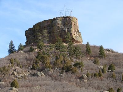
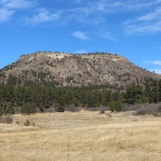
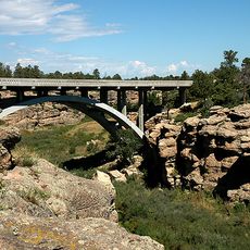
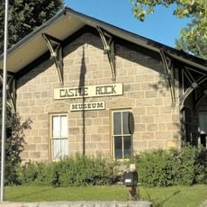
Castle Rock, Natural butte in Castle Rock, Colorado.

Description

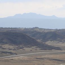
Castle Rock is a butte made of rhyolite stone that rises sharply from the landscape in Douglas County, Colorado, and dominates the view of the town below. The rock shows how layers of hard material have been exposed and shaped by wind and water over countless years.

History

When rhyolite deposits were found near the butte in the 1870s, settlers moved to the area and established permanent communities around it. The combination of valuable stone and the distinctive landmark shaped the growth of what became the town of Castle Rock.

Culture

Native American tribes like the Arapaho and Cheyenne used this formation as a key landmark for finding their way across the region. The rock became woven into their knowledge of the land and how they moved through it.

Practical

The butte is easily visible from town and serves as a helpful reference point for getting around the area. The site becomes particularly notable during the holiday season when a large electric star is lit on top, making it stand out even more against the sky.

Did you know?

The butte inspired the very name of the town, as early settlers thought its shape resembled a castle fortress. Walking through town and looking up at the distinctive profile explains exactly why that comparison made such sense to the people who settled here.

Location
GPS coordinates
39.37909,-104.85605
Latest update
December 10, 2025 15:47

AroundUs brings together thousands of curated places, local tips, and hidden gems, enriched daily by 60,000 contributors worldwide. Discover all places nearby (Castle Rock).

Around this place
Castlewood Canyon State Park
United States of America

Castlewood Canyon State Park

11.5 km
Chatfield State Park
United States of America

Chatfield State Park

25.4 km
Roxborough State Park
United States of America

Roxborough State Park

19.2 km
Chatfield Reservoir
United States of America

Chatfield Reservoir

25.9 km
Devil's Head Lookout
United States of America

Devil's Head Lookout

24.9 km
Colorado Piedmont
United States of America

Colorado Piedmont

22.2 km
Denver Colorado Temple
United States of America

Denver Colorado Temple

23.1 km
Devils Head
United States of America

Devils Head

24.9 km
Rueter-Hess Reservoir
United States of America

Rueter-Hess Reservoir

12.5 km
Platte Canyon
United States of America

Platte Canyon

24.5 km
Dawson Butte
United States of America

Dawson Butte

11.2 km
Cherry Creek Bridge
United States of America

Cherry Creek Bridge

11.9 km
Cherokee Ranch
United States of America

Cherokee Ranch

11.3 km
Seventeen Mile House
United States of America

Seventeen Mile House

21.9 km
Ridgeline Open Space
United States of America

Ridgeline Open Space

4.3 km
Pike's Peak Grange No. 163
United States of America

Pike's Peak Grange No. 163

8.8 km
Castle Rock Depot
United States of America

Castle Rock Depot

778 m
Melvin School
United States of America

Melvin School

27.9 km
Church of St. Philip-in-the-Field and Bear Canon Cemetery
United States of America

Church of St. Philip-in-the-Field and Bear Canon Cemetery

9 km
Ruth Memorial Methodist Episcopal Church
United States of America

Ruth Memorial Methodist Episcopal Church

17.6 km
Reginald Sinclaire House
United States of America

Reginald Sinclaire House

13.4 km
Santa Fe Railway Water Tank
United States of America

Santa Fe Railway Water Tank

11.5 km
First National Bank of Douglas County
United States of America

First National Bank of Douglas County

806 m
Curtis School
United States of America

Curtis School

27.2 km
John Kinner House
United States of America

John Kinner House

14.8 km
Marjorie Park(Fiddlers Green Art Park)
United States of America

Marjorie Park(Fiddlers Green Art Park)

25 km
Arboreto de Chatfield
United States of America

Arboreto de Chatfield

27.9 km
The Dr. Seuss Experience
United States of America

The Dr. Seuss Experience

21.3 km
Show the full map
« Castle Rock - Natural butte in Castle Rock, Colorado » is provided by Around Us (aroundus.com). Images and texts are derived from Wikimedia project under a Creative Commons license. You are allowed to copy, distribute, and modify copies of this page, under the conditions set by the license, as long as this note is clearly visible.

Discover hidden gems everywhere you go!

From secret cafés to breathtaking viewpoints, skip the crowded tourist spots and find places that match your style. Our app makes it easy with voice search, smart filtering, route optimization, and insider tips from travelers worldwide. Download now for the complete mobile experience.

Around Us App Screenshot

A unique approach to discovering new places

Le Figaro

All the places worth exploring

France Info

A tailor-made excursion in just a few clicks

20 Minutes

Around Us
Travel Guide & Maps
Download

Send to your phone

QR Code
1

Open the camera app on your mobile.

2

Point at the QR code with your camera. A notification will appear.

3

Tap the notification to open the link.