Enable Location

We need your location to show you interesting places around you

Discover nearby places

Find interesting locations and hidden gems around you

Precise directions

Get accurate directions and distances to places

Your location is never shared with other users. It's only used when you tap the location button.

Fields Spring State Park

Log in to your account

Start exploring — it's free

Trusted by 61,512 travelers worldwide

Continue with Google
Continue with Apple
or

We will send you a code to connect

By continuing, you accept our Terms and Conditions and our Privacy Policy

Check your inbox

We've sent a pincode in your inbox. Please enter the code below.

Fields Spring State Park

Fields Spring State Park, State park in Asotin County, Washington

Description

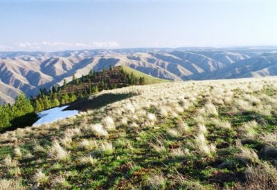
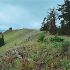
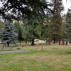
Fields Spring State Park is a forested area covering about 828 acres in the Blue Mountains, reaching elevations of about 4,500 feet at Puffer Butte. The land features a dense mix of Douglas fir and white fir trees along with other vegetation that covers the rugged mountain terrain.

History

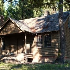
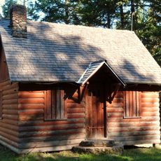
The park was established in 1930 and received extensive development work through the Works Progress Administration in the following years. This infrastructure work transformed it into a usable space for visitors in the otherwise remote mountain region.

Culture

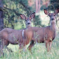
This location sits along routes historically used by the Nez Perce people for hunting and trade throughout the mountainous region. The area maintained its role as a passageway between different territories.

Practical

The park offers 20 tent spaces for tents and RVs up to about 30 feet long, with restrooms and shower facilities available. The grounds are relatively straightforward to navigate, though you should prepare for mountainous terrain and changing weather conditions.

Did you know?

In the 1970s, a large portion of the tree population had to be removed after a pest outbreak caused widespread damage to the forest. This drastic change shaped how the park looks today and later allowed for replanting with new growth.

Location
Location
Inception
1930
GPS coordinates
46.07722,-117.17194
Latest update
December 12, 2025 12:02

AroundUs brings together thousands of curated places, local tips, and hidden gems, enriched daily by 60,000 contributors worldwide. Discover all places nearby (Washington).

Around this place
Nez Perce National Historical Park
United States of America

Nez Perce National Historical Park

49.1 km
Wenaha–Tucannon Wilderness
United States of America

Wenaha–Tucannon Wilderness

36.3 km
Lewiston Hill
United States of America

Lewiston Hill

45.6 km
Fort Lapwai
United States of America

Fort Lapwai

49.7 km
Minam State Recreation Area
United States of America

Minam State Recreation Area

53.5 km
Wenaha Wildlife Area
United States of America

Wenaha Wildlife Area

33 km
Lewis and Clark Trail-Travois Road
United States of America

Lewis and Clark Trail-Travois Road

49.2 km
Sternwheeler Jean
United States of America

Sternwheeler Jean

33.8 km
Full Gospel Church
United States of America

Full Gospel Church

30.9 km
St. Boniface Church, Convent and Rectory
United States of America

St. Boniface Church, Convent and Rectory

51.9 km
Interstate Highway Bridge
United States of America

Interstate Highway Bridge

39.6 km
Billy Meadows Guard Station
United States of America

Billy Meadows Guard Station

29.4 km
Kirkland Lookout Ground House
United States of America

Kirkland Lookout Ground House

26.8 km
Gaylord Thompson House
United States of America

Gaylord Thompson House

38.4 km
First Presbyterian Church
United States of America

First Presbyterian Church

46.2 km
21 Ranchhouse
United States of America

21 Ranchhouse

29.2 km
Garfield County Courthouse
United States of America

Garfield County Courthouse

55.2 km
Indian Timothy Memorial Bridge
United States of America

Indian Timothy Memorial Bridge

37.4 km
Grande Ronde River Bridge
United States of America

Grande Ronde River Bridge

7.4 km
Nave Apartments
United States of America

Nave Apartments

39.2 km
James Asposas House
United States of America

James Asposas House

38.6 km
Clarkston Public Library
United States of America

Clarkston Public Library

38.4 km
Hoodoo Ridge Lookout
United States of America

Hoodoo Ridge Lookout

36.9 km
Frank Booth House
United States of America

Frank Booth House

38.4 km
William and Elizabeth McLaren House
United States of America

William and Elizabeth McLaren House

38.6 km
C. C. Van Arsdol House
United States of America

C. C. Van Arsdol House

37.9 km
Agnes M. Tamblyn House
United States of America

Agnes M. Tamblyn House

38.3 km
Temple Theatre
United States of America

Temple Theatre

39.9 km
Show the full map
« Fields Spring State Park - State park in Asotin County, Washington » is provided by Around Us (aroundus.com). Images and texts are derived from Wikimedia project under a Creative Commons license. You are allowed to copy, distribute, and modify copies of this page, under the conditions set by the license, as long as this note is clearly visible.

Discover hidden gems everywhere you go!

From secret cafés to breathtaking viewpoints, skip the crowded tourist spots and find places that match your style. Our app makes it easy with voice search, smart filtering, route optimization, and insider tips from travelers worldwide. Download now for the complete mobile experience.

Around Us App Screenshot

A unique approach to discovering new places

Le Figaro

All the places worth exploring

France Info

A tailor-made excursion in just a few clicks

20 Minutes

Around Us
Travel Guide & Maps
Download

Send to your phone

QR Code
1

Open the camera app on your mobile.

2

Point at the QR code with your camera. A notification will appear.

3

Tap the notification to open the link.