Enable Location

We need your location to show you interesting places around you

Discover nearby places

Find interesting locations and hidden gems around you

Precise directions

Get accurate directions and distances to places

Your location is never shared with other users. It's only used when you tap the location button.

Fort Walla Walla

Log in to your account

Start exploring — it's free

Trusted by 62,354 travelers worldwide

Continue with Google
Continue with Apple
or

We will send you a code to connect

By continuing, you accept our Terms and Conditions and our Privacy Policy

Check your inbox

We've sent a pincode in your inbox. Please enter the code below.

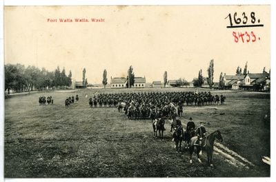
Fort Walla Walla, Military fort historic district in Walla Walla, United States.

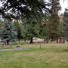
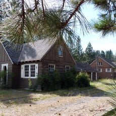
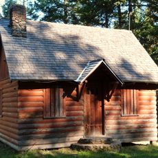
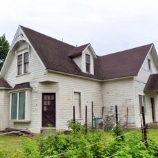
Fort Walla Walla is a military outpost in Washington featuring original buildings from the 1800s, including barracks, officers' homes, and administrative structures arranged across defined grounds. The site is registered as a historic district, preserving the layout and character of the frontier installation.

The United States Army established this installation in 1856 as a defensive position to protect settlers and maintain authority during regional conflicts. Its presence shaped the development of the surrounding territory and represented military commitment to expanding American control in the Pacific Northwest.

The way buildings are arranged across the grounds reflects how soldiers and their families organized daily life at this remote outpost. Walking through the structures, you can see where people worked, slept, and gathered, offering insight into frontier military routines.

The grounds are open from sunrise to sunset, and a museum on-site offers guided tours to help you understand what you are seeing. Wear comfortable shoes since you will walk between several buildings spread across the property.

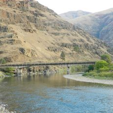
The fort sat near where two major rivers meet, making it a key distribution hub for military supplies across the region. This river location was the main reason the site was chosen for the base and explains why it remained important throughout its years of operation.

The community of curious travelers

AroundUs brings together thousands of curated places, local tips, and hidden gems, enriched daily by 60,000 contributors worldwide.

Start exploring
Location
GPS coordinates
46.04740,-118.35700
Latest update
December 8, 2025 19:57
Around this place
Wenaha–Tucannon Wilderness
United States of America

Wenaha–Tucannon Wilderness

55.6 km
North Fork Umatilla Wilderness
United States of America

North Fork Umatilla Wilderness

40.2 km
Fields Spring State Park
United States of America

Fields Spring State Park

91.6 km
Jubilee Lake
United States of America

Jubilee Lake

39 km
Borleske Stadium
United States of America

Borleske Stadium

3.7 km
Wallowa Lake Highway Forest State Scenic Corridor
United States of America

Wallowa Lake Highway Forest State Scenic Corridor

70.4 km
Minam State Recreation Area
United States of America

Minam State Recreation Area

57.6 km
Eagle Cap Excursion Train
United States of America

Eagle Cap Excursion Train

63.4 km
Wenaha Wildlife Area
United States of America

Wenaha Wildlife Area

66.6 km
Wallowa River Rest Area
United States of America

Wallowa River Rest Area

74.9 km
Lewis and Clark Trail-Travois Road
United States of America

Lewis and Clark Trail-Travois Road

81.9 km
Sternwheeler Jean
United States of America

Sternwheeler Jean

106.4 km
Full Gospel Church
United States of America

Full Gospel Church

105.9 km
Kirkman House
United States of America

Kirkman House

2.9 km
Elgin Opera House
United States of America

Elgin Opera House

63.5 km
Billy Meadows Guard Station
United States of America

Billy Meadows Guard Station

104.7 km
Electric Light Works Building
United States of America

Electric Light Works Building

2.2 km
Langdon Lake
United States of America

Langdon Lake

36.6 km
Wallowa Ranger Station
United States of America

Wallowa Ranger Station

83 km
Kirkland Lookout Ground House
United States of America

Kirkland Lookout Ground House

97.7 km
Garfield County Courthouse
United States of America

Garfield County Courthouse

75.2 km
Indian Timothy Memorial Bridge
United States of America

Indian Timothy Memorial Bridge

97 km
Grande Ronde River Bridge
United States of America

Grande Ronde River Bridge

85.3 km
Preston Hall
United States of America

Preston Hall

29 km
Hoodoo Ridge Lookout
United States of America

Hoodoo Ridge Lookout

58.7 km
Hunter–Morelock House
United States of America

Hunter–Morelock House

83.7 km
C. C. Van Arsdol House
United States of America

C. C. Van Arsdol House

107.1 km
Walla Walla Valley Traction Company Car Barn
United States of America

Walla Walla Valley Traction Company Car Barn

2.3 km
Show the full map
« Fort Walla Walla - Military fort historic district in Walla Walla, United States » is provided by Around Us (aroundus.com). Images and texts are derived from Wikimedia project under a Creative Commons license. You are allowed to copy, distribute, and modify copies of this page, under the conditions set by the license, as long as this note is clearly visible.

Discover hidden gems everywhere you go!

From secret cafés to breathtaking viewpoints, skip the crowded tourist spots and find places that match your style. Our app makes it easy with voice search, smart filtering, route optimization, and insider tips from travelers worldwide. Download now for the complete mobile experience.

Around Us App Screenshot

A unique approach to discovering new places

Le Figaro

All the places worth exploring

France Info

A tailor-made excursion in just a few clicks

20 Minutes

Around Us
Travel Guide & Maps
Download

Send to your phone

QR Code
1

Open the camera app on your mobile.

2

Point at the QR code with your camera. A notification will appear.

3

Tap the notification to open the link.