Coffre ${chestReward.rarityLabel}
+${chestReward.xp} XP
Explorer
NOUVEAU ×${chestReward.collectible.quantity}
tapez pour fermer

Enable Location

We need your location to show you interesting places around you

Discover nearby places

Find interesting locations and hidden gems around you

Precise directions

Get accurate directions and distances to places

Your location is never shared with other users. It's only used when you tap the location button.

Noxon Rapids Dam

Log in to your account

Start exploring — it's free

Trusted by 70,358 travelers worldwide

Continue with Google
Continue with Apple
or

We will send you a code to connect

By continuing, you accept our Terms and Conditions and our Privacy Policy

Check your inbox

We've sent a pincode in your inbox. Please enter the code below.

Discussion Reviews 1 Photos
2.5k Popularity

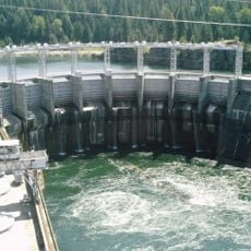
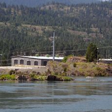
Noxon Rapids Dam, Hydroelectric power station on Clark Fork River, Montana.

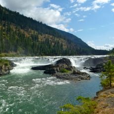
Noxon Rapids Dam is a concrete hydroelectric facility spanning the Clark Fork River in Montana and powered by multiple turbines to generate electricity. The structure regulates water levels in a large reservoir that stores runoff and releases it through the turbines.

Washington Water Power started construction in 1956 and completed this facility by 1959. The project marked an important step in developing hydroelectric power across the Montana region.

The Historic American Engineering Record maintains detailed documentation of the dam's development, recording its impact on regional industrial advancement.

Visitors can view the facility from overlook points near the dam where its scale becomes more apparent. The site is best accessed during daylight hours when light illuminates the structure and surrounding landscape.

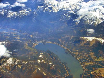
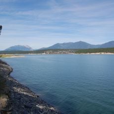
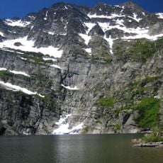
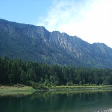
The dam creates a 7,700-acre reservoir that captures water from a catchment area spanning 21,800 square miles in northwestern Montana.

The community of curious travelers

AroundUs brings together thousands of curated places, local tips, and hidden gems, enriched daily by 60,000 contributors worldwide.

Start exploring
Location
Inception
1956
GPS coordinates
47.96000,-115.73400
Latest update
December 12, 2025 17:45
Around this place
Lake Koocanusa
United States of America

Lake Koocanusa

144.6 km
Kootenai Falls
United States of America

Kootenai Falls

55.2 km
Idaho Panhandle National Forests
United States of America

Idaho Panhandle National Forests

45.1 km
Snowshoe Peak
United States of America

Snowshoe Peak

29.5 km
Cabinet Gorge Dam
United States of America

Cabinet Gorge Dam

28.3 km
Thompson Falls State Park
United States of America

Thompson Falls State Park

46 km
Theodore Roosevelt Memorial Bridge
United States of America

Theodore Roosevelt Memorial Bridge

57.9 km
Gem Saloon
United States of America

Gem Saloon

50 km
Kootenai Falls Swinging Bridge
United States of America

Kootenai Falls Swinging Bridge

55 km
United States of America

Burke Canyon

50.5 km
Libby High School
United States of America

Libby High School

49.5 km
Wallace Historic District
United States of America

Wallace Historic District

56.2 km
Tourist Hotel
United States of America

Tourist Hotel

50 km
Cabinet National Forest
United States of America

Cabinet National Forest

20.3 km
Wallace 1910 Fire Memorial
United States of America

Wallace 1910 Fire Memorial

54.2 km
Wallace Carnegie Library
United States of America

Wallace Carnegie Library

56 km
Sanders County Jail
United States of America

Sanders County Jail

49.8 km
Crystal Gold Mine
United States of America

Crystal Gold Mine

54.6 km
Bedard House
United States of America

Bedard House

49.8 km
Ainsworth House
United States of America

Ainsworth House

49.5 km
Bull River Guard Station
United States of America

Bull River Guard Station

16.6 km
Preston House
United States of America

Preston House

50 km
Thayer House
United States of America

Thayer House

49.7 km
Grandchamp House
United States of America

Grandchamp House

49.4 km
Thompson Falls Hydroelectric Dam Historic District
United States of America

Thompson Falls Hydroelectric Dam Historic District

49.6 km
Hoyt House
United States of America

Hoyt House

49.5 km
Griffen House
United States of America

Griffen House

49.4 km
Northern Pacific Railroad Depot Museum
United States of America

Northern Pacific Railroad Depot Museum

56 km
Show the full map
Reviews
Share your experience

No review yet

Discussions
Start a discussion...

No discussion yet

« Noxon Rapids Dam - Hydroelectric power station on Clark Fork River, Montana » is provided by Around Us (aroundus.com). Images and texts are derived from Wikimedia project under a Creative Commons license. You are allowed to copy, distribute, and modify copies of this page, under the conditions set by the license, as long as this note is clearly visible.

Discover hidden gems everywhere you go!

From secret cafés to breathtaking viewpoints, skip the crowded tourist spots and find places that match your style. Our app makes it easy with voice search, smart filtering, route optimization, and insider tips from travelers worldwide. Download now for the complete mobile experience.

Around Us App Screenshot

A unique approach to discovering new places

Le Figaro

All the places worth exploring

France Info

A tailor-made excursion in just a few clicks

20 Minutes

Around Us
Travel Guide & Maps
Download

Send to your phone

QR Code
1

Open the camera app on your mobile.

2

Point at the QR code with your camera. A notification will appear.

3

Tap the notification to open the link.