Enable Location

We need your location to show you interesting places around you

Discover nearby places

Find interesting locations and hidden gems around you

Precise directions

Get accurate directions and distances to places

Your location is never shared with other users. It's only used when you tap the location button.

Kootenai Falls

Log in to your account

Start exploring — it's free

Trusted by 62,356 travelers worldwide

Continue with Google
Continue with Apple
or

We will send you a code to connect

By continuing, you accept our Terms and Conditions and our Privacy Policy

Check your inbox

We've sent a pincode in your inbox. Please enter the code below.

Kootenai Falls

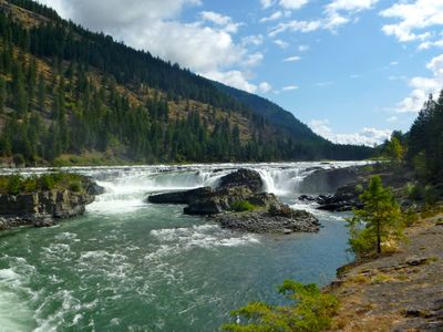
Kootenai Falls, Natural waterfall in Lincoln County, Montana, United States.

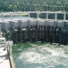
Kootenai Falls is a large waterfall system on the Kootenai River in Montana that spans a broad width and consists of multiple water tiers. The water descends the river with significant force, creating a dramatic water display across the landscape.

Canadian explorer David Thompson traveled the Kootenai region in the early 1800s, following trails established by Native Americans around this area. His journeys helped document the landscape and river routes of the region.

This waterfall holds spiritual importance for the Kootenai Tribe, who view this location as a place where they connect with their guiding spirits. Visitors can sense the deep bond that tribal members have with this site when experiencing the cascading waters.

This site is accessible via a walking trail from the parking area near U.S. Route 2, with no entrance fee required. Visitors should wear sturdy footwear since the path passes through wooded terrain and conditions vary depending on the season.

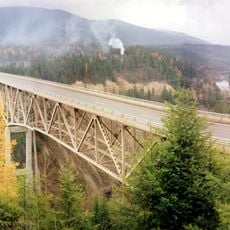
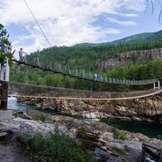
A suspension footbridge built in 2019 crosses the river near the falls, allowing visitors to view the cascading waters from multiple angles above the water itself. This structure provides vantage points that would otherwise be impossible to reach on foot.

The community of curious travelers

AroundUs brings together thousands of curated places, local tips, and hidden gems, enriched daily by 60,000 contributors worldwide.

Start exploring
Location
GPS coordinates
48.45550,-115.76322
Latest update
December 9, 2025 18:40
Around this place
Silverwood Theme Park
United States of America

Silverwood Theme Park

92.7 km
Lake Koocanusa
Canada

Lake Koocanusa

93 km
Farragut State Park
United States of America

Farragut State Park

81.6 km
Libby Dam
United States of America

Libby Dam

33.8 km
Idaho Panhandle National Forests
United States of America

Idaho Panhandle National Forests

88.9 km
Porthill-Rykerts Border Crossing
Canada

Porthill-Rykerts Border Crossing

81.2 km
Kootenai National Wildlife Refuge
United States of America

Kootenai National Wildlife Refuge

55.3 km
Snowshoe Peak
United States of America

Snowshoe Peak

26.5 km
Moyie River Canyon Bridge
United States of America

Moyie River Canyon Bridge

43.3 km
Cabinet Gorge Dam
United States of America

Cabinet Gorge Dam

46.7 km
City Beach
United States of America

City Beach

61 km
Round Lake State Park
United States of America

Round Lake State Park

72.4 km
Lost Trail National Wildlife Refuge
United States of America

Lost Trail National Wildlife Refuge

71.5 km
Theodore Roosevelt Memorial Bridge
United States of America

Theodore Roosevelt Memorial Bridge

9.2 km
Boulder Beach Water Park
United States of America

Boulder Beach Water Park

92.3 km
Kootenai Falls Swinging Bridge
United States of America

Kootenai Falls Swinging Bridge

675 m
Libby High School
United States of America

Libby High School

17.2 km
Troy Jail
United States of America

Troy Jail

9.3 km
Farmers and Merchants State Bank
United States of America

Farmers and Merchants State Bank

70.5 km
Ant Flat Ranger Station
United States of America

Ant Flat Ranger Station

71.8 km
Cabinet National Forest
United States of America

Cabinet National Forest

53.7 km
Eureka Community Hall
United States of America

Eureka Community Hall

51.2 km
Dover Church
United States of America

Dover Church

66.4 km
Boundary County Courthouse
United States of America

Boundary County Courthouse

48.5 km
Amanda Nesbitt House
United States of America

Amanda Nesbitt House

61.5 km
Sandpoint Federal Building
United States of America

Sandpoint Federal Building

61.4 km
Russell and Pearl Soderling House
United States of America

Russell and Pearl Soderling House

48.6 km
Bull River Guard Station
United States of America

Bull River Guard Station

38.8 km
Show the full map
« Kootenai Falls - Natural waterfall in Lincoln County, Montana, United States » is provided by Around Us (aroundus.com). Images and texts are derived from Wikimedia project under a Creative Commons license. You are allowed to copy, distribute, and modify copies of this page, under the conditions set by the license, as long as this note is clearly visible.

Discover hidden gems everywhere you go!

From secret cafés to breathtaking viewpoints, skip the crowded tourist spots and find places that match your style. Our app makes it easy with voice search, smart filtering, route optimization, and insider tips from travelers worldwide. Download now for the complete mobile experience.

Around Us App Screenshot

A unique approach to discovering new places

Le Figaro

All the places worth exploring

France Info

A tailor-made excursion in just a few clicks

20 Minutes

Around Us
Travel Guide & Maps
Download

Send to your phone

QR Code
1

Open the camera app on your mobile.

2

Point at the QR code with your camera. A notification will appear.

3

Tap the notification to open the link.