Enable Location

We need your location to show you interesting places around you

Discover nearby places

Find interesting locations and hidden gems around you

Precise directions

Get accurate directions and distances to places

Your location is never shared with other users. It's only used when you tap the location button.

Libby High School

Log in to your account

Start exploring — it's free

Trusted by 62,357 travelers worldwide

Continue with Google
Continue with Apple
or

We will send you a code to connect

By continuing, you accept our Terms and Conditions and our Privacy Policy

Check your inbox

We've sent a pincode in your inbox. Please enter the code below.

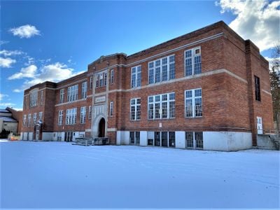
Libby High School, high school in Montana, United States

Libby High School is a school building in Libby, Montana, that dates from the early 1900s and has been part of the community for decades. The large brick structure with many windows and a prominent front entrance shows clear signs of age, including a partially collapsed roof and broken windows.

The building was constructed in the early 1900s and initially served as the town's main high school, later as an elementary school, and until the year 2000 as the site of the local college campus. In 2008 the school district sold the building with plans to convert it into condominiums and offices, but the project halted after the death of one partner, leaving the building vacant since.

The building carries the name of an institution that was central to generations of students and remains a symbol of education in the town of Libby. The community keeps alive memories of school events and personal moments that shaped the town's sense of identity.

The building is surrounded by a fence and located next to a park in the town of Libby, making it easy to spot when visiting the area. Its condition is challenging due to the collapsed roof and broken windows, so entry is unsafe and should be avoided.

The building's roof collapsed in 2017, yet today there are plans to convert it into approximately 60 apartments with some reserved specifically for teachers, supported by state funding for historic preservation. The restoration aims to preserve the original brick appearance while modernizing the structure.

The community of curious travelers

AroundUs brings together thousands of curated places, local tips, and hidden gems, enriched daily by 60,000 contributors worldwide.

Start exploring
Location
GPS coordinates
48.38806,-115.55361
Latest update
February 9, 2026 08:19
Around this place
Lake Koocanusa
Canada

Lake Koocanusa

95.1 km
Libby Dam
United States of America

Libby Dam

18.1 km
Kootenai Falls
United States of America

Kootenai Falls

17.2 km
Whitefish Lake State Park
United States of America

Whitefish Lake State Park

87.6 km
Kootenai National Wildlife Refuge
United States of America

Kootenai National Wildlife Refuge

72.4 km
Snowshoe Peak
United States of America

Snowshoe Peak

20.9 km
Moyie River Canyon Bridge
United States of America

Moyie River Canyon Bridge

59.8 km
Cabinet Gorge Dam
United States of America

Cabinet Gorge Dam

50.6 km
Noxon Rapids Dam
United States of America

Noxon Rapids Dam

49.5 km
Round Lake State Park
United States of America

Round Lake State Park

84.1 km
Lost Trail National Wildlife Refuge
United States of America

Lost Trail National Wildlife Refuge

54.3 km
Thompson Falls State Park
United States of America

Thompson Falls State Park

86.6 km
Theodore Roosevelt Memorial Bridge
United States of America

Theodore Roosevelt Memorial Bridge

26.2 km
Kootenai Falls Swinging Bridge
United States of America

Kootenai Falls Swinging Bridge

17.7 km
Farmers and Merchants State Bank
United States of America

Farmers and Merchants State Bank

66.1 km
Ant Flat Ranger Station
United States of America

Ant Flat Ranger Station

62.3 km
Cabinet National Forest
United States of America

Cabinet National Forest

54.4 km
Eureka Community Hall
United States of America

Eureka Community Hall

65.1 km
Dover Church
United States of America

Dover Church

79.4 km
Boundary County Courthouse
United States of America

Boundary County Courthouse

65.6 km
Amanda Nesbitt House
United States of America

Amanda Nesbitt House

74.8 km
Sandpoint Federal Building
United States of America

Sandpoint Federal Building

74.7 km
Russell and Pearl Soderling House
United States of America

Russell and Pearl Soderling House

65.7 km
Bull River Guard Station
United States of America

Bull River Guard Station

35.5 km
Thayer House
United States of America

Thayer House

89.4 km
Grandchamp House
United States of America

Grandchamp House

89.3 km
Hoyt House
United States of America

Hoyt House

89.3 km
Griffen House
United States of America

Griffen House

89.2 km
Show the full map
« Libby High School - high school in Montana, United States » is provided by Around Us (aroundus.com). Images and texts are derived from Wikimedia project under a Creative Commons license. You are allowed to copy, distribute, and modify copies of this page, under the conditions set by the license, as long as this note is clearly visible.

Discover hidden gems everywhere you go!

From secret cafés to breathtaking viewpoints, skip the crowded tourist spots and find places that match your style. Our app makes it easy with voice search, smart filtering, route optimization, and insider tips from travelers worldwide. Download now for the complete mobile experience.

Around Us App Screenshot

A unique approach to discovering new places

Le Figaro

All the places worth exploring

France Info

A tailor-made excursion in just a few clicks

20 Minutes

Around Us
Travel Guide & Maps
Download

Send to your phone

QR Code
1

Open the camera app on your mobile.

2

Point at the QR code with your camera. A notification will appear.

3

Tap the notification to open the link.