Ninepipe National Wildlife Refuge

Log in to your account

AroundUs is a community-driven map of interesting places, built by curious explorers like you. It grows with every review, story, and photo you share.
Connect to save your favorite spots, contribute locations, and create personalized routes.
Continue with Google
Continue with Apple
Continue with X
Continue with Facebook
Continue with email
By continuing, you accept our Terms and Conditions and our Privacy Policy
Create an account

Ninepipe National Wildlife Refuge

Add to collection
Map
Suggest a change
Share

Ninepipe National Wildlife Refuge, Wildlife refuge in Lake County, Montana.

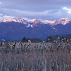
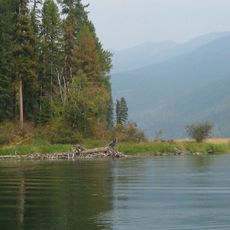
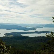
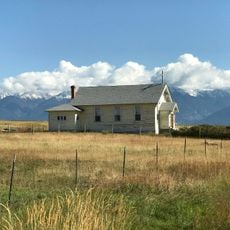
Ninepipe National Wildlife Refuge is a protected area in the Mission Valley consisting of around 4000 acres of wetlands and grasslands with a central reservoir surrounded by numerous ponds and marsh vegetation. The landscape provides diverse habitats for waterfowl and other wildlife across this wide, open valley.

The area was first set aside in 1910 for irrigation purposes before becoming an official National Wildlife Refuge through a presidential order in 1921. This shift reflected changing priorities from water management to wildlife protection and habitat conservation.

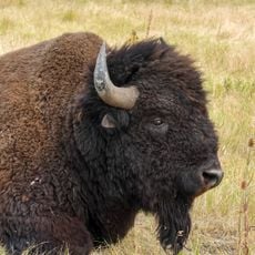
The Confederated Salish and Kootenai Tribes maintain strong ties to this land and play an active role in managing fish populations and conservation work. Their presence shapes how the refuge is cared for and valued by the broader community.

The refuge sits directly along U.S. Highway 93 and is easy to reach for viewing and photography of wildlife. Early morning and late afternoon visits often provide the best chances to observe birds and animals when they are most active.

The refuge contains hundreds of glacial pothole wetlands that form an intricate network of habitats where waterfowl breed and rest during migration. These specialized environments make it a significant stopping point along major bird migration routes across the continent.

Location: Montana

Website: https://fws.gov/refuge/nine-pipe

GPS coordinates: 47.44250,-114.11900

Latest update: December 12, 2025 14:26

Photos
Around this place
Lake Missoula
United States of America

Lake Missoula

56.1 km
CSKT Bison Range
United States of America

CSKT Bison Range

15.1 km
The Garden of One Thousand Buddhas
United States of America

The Garden of One Thousand Buddhas

28 km
McDonald Peak
United States of America

McDonald Peak

16.5 km
Placid Lake State Park
United States of America

Placid Lake State Park

58.8 km
Pablo National Wildlife Refuge
United States of America

Pablo National Wildlife Refuge

21.6 km
United States of America

Council Grove State Park

59 km
Swan River National Wildlife Refuge
United States of America

Swan River National Wildlife Refuge

54.4 km
Lake Mary Ronan State Park
United States of America

Lake Mary Ronan State Park

57.5 km
Finley Point State Park
United States of America

Finley Point State Park

34.9 km
CSKT Bison Range
United States of America

CSKT Bison Range

13.1 km
Yellow Bay State Park
United States of America

Yellow Bay State Park

48.7 km
West Shore State Park
United States of America

West Shore State Park

59.9 km
St. Joseph's Catholic Church
United States of America

St. Joseph's Catholic Church

8.7 km
Fort Connah Site
United States of America

Fort Connah Site

4.8 km
Brinks House
United States of America

Brinks House

55.9 km
Alberton School
United States of America

Alberton School

55.9 km
Natural Pier Bridge
United States of America

Natural Pier Bridge

56 km
Don E. Olsson House and Garage
United States of America

Don E. Olsson House and Garage

9.6 km
Miracle of America Museum and Pioneer Village
United States of America

Miracle of America Museum and Pioneer Village

26.5 km
Dayton State Bank
United States of America

Dayton State Bank

48.4 km
Polson Feed Mill
United States of America

Polson Feed Mill

27.9 km
Marent Gulch Trestle
United States of America

Marent Gulch Trestle

48.9 km
Mrs. Lydia McCaffery's Furnished Rooms
United States of America

Mrs. Lydia McCaffery's Furnished Rooms

63.7 km
Wilson House
United States of America

Wilson House

55.8 km
Chadwick House
United States of America

Chadwick House

55.9 km
Mineral Peak Lookout
United States of America

Mineral Peak Lookout

54.1 km
The People's Center
United States of America

The People's Center

13.4 km
Show the full map
Reviews

Visited this place? Tap the stars to rate it and share your experience / photos with the community! Try now! You can cancel it anytime.

« Ninepipe National Wildlife Refuge - Wildlife refuge in Lake County, Montana » is provided by Around Us (aroundus.com). Images and texts are derived from Wikimedia project under a Creative Commons license. You are allowed to copy, distribute, and modify copies of this page, under the conditions set by the license, as long as this note is clearly visible.

Discover hidden gems everywhere you go!

From secret cafés to breathtaking viewpoints, skip the crowded tourist spots and find places that match your style. Our app makes it easy with voice search, smart filtering, route optimization, and insider tips from travelers worldwide. Download now for the complete mobile experience.

Around Us App Screenshot

A unique approach to discovering new places

Le Figaro

All the places worth exploring

France Info

A tailor-made excursion in just a few clicks

20 Minutes