Gibson Dam

Log in to your account

AroundUs is a community-driven map of interesting places, built by curious explorers like you. It grows with every review, story, and photo you share.
Connect to save your favorite spots, contribute locations, and create personalized routes.
Continue with Google
Continue with Apple
Continue with X
Continue with Facebook
Continue with email
By continuing, you accept our Terms and Conditions and our Privacy Policy
Create an account
Add to collection
Map
Suggest a change
Share

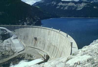
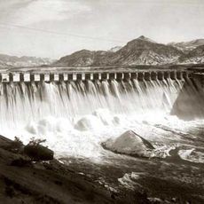
Gibson Dam, Concrete arch dam in Teton County, Montana.

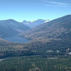
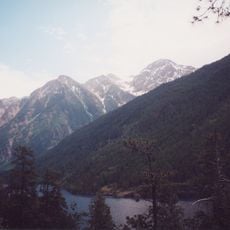
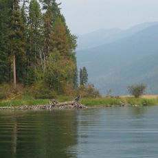
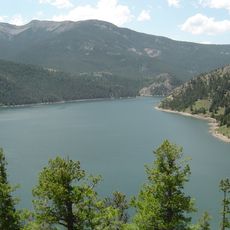
Gibson Dam is a concrete arch dam spanning the Sun River, characterized by its thick concrete structure that tapers from a broad base to a narrower crest. Behind the structure lies a large reservoir where water accumulates for storage and distribution downstream.

The dam was built between 1926 and 1929 by the United States Bureau of Reclamation. This project marked an important advancement in engineering methods, as it relied on new mathematical techniques for analyzing structural behavior.

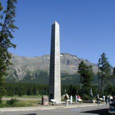
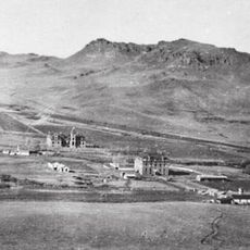
The dam takes its name from an engineer whose work shaped water management in this region. Visitors can observe how this structure has become part of the local landscape and its role in the community's daily relationship with the Sun River.

The dam is accessible by a local road that provides several vantage points along its length. Water levels change significantly throughout the year depending on snowmelt and irrigation demands, so what you see varies by season.

Engineers built a full-scale model of the dam before construction to test how it would perform during extreme flood conditions. This testing approach helped confirm the safety of the design before any concrete was poured.

Location: Teton County

GPS coordinates: 47.60330,-112.76100

Latest update: December 12, 2025 14:27

Photos
Around this place
Bob Marshall Wilderness
United States of America

Bob Marshall Wilderness

33 km
Two Medicine Formation
Canada

Two Medicine Formation

62.8 km
Marias Pass
United States of America

Marias Pass

91.1 km
Great Bear Wilderness
United States of America

Great Bear Wilderness

89.3 km
First Peoples Buffalo Jump State Park
United States of America

First Peoples Buffalo Jump State Park

93.4 km
Holter Dam
United States of America

Holter Dam

88.8 km
St. Peter's Mission Church and Cemetery
United States of America

St. Peter's Mission Church and Cemetery

71.6 km
Scapegoat Wilderness
United States of America

Scapegoat Wilderness

54.2 km
McDonald Peak
United States of America

McDonald Peak

90.5 km
Hardy Bridge
United States of America

Hardy Bridge

85.1 km
Tower Rock State Park
United States of America

Tower Rock State Park

85.2 km
Placid Lake State Park
United States of America

Placid Lake State Park

77.7 km
J. C. Adams Stone Barn
United States of America

J. C. Adams Stone Barn

81 km
Swan River National Wildlife Refuge
United States of America

Swan River National Wildlife Refuge

88.2 km
Gibson Reservoir
United States of America

Gibson Reservoir

13 m
Dearborn River High Bridge
United States of America

Dearborn River High Bridge

45.4 km
Summit Mountain
United States of America

Summit Mountain

95.1 km
Scenic Bridge
United States of America

Scenic Bridge

86.9 km
Garnet Ghost Town
United States of America

Garnet Ghost Town

97 km
Silver King Ranch
United States of America

Silver King Ranch

61 km
Teton County Courthouse
United States of America

Teton County Courthouse

49.2 km
Gable Peaks
United States of America

Gable Peaks

57.7 km
Fielding Snowshoe Patrol Cabin
United States of America

Fielding Snowshoe Patrol Cabin

92.1 km
The Montana Dinosaur Center
United States of America

The Montana Dinosaur Center

53.4 km
Orpheum Theatre
United States of America

Orpheum Theatre

87.6 km
Latigo & Lace
United States of America

Latigo & Lace

30.4 km
Craig Bridge
United States of America

Craig Bridge

84.3 km
Charlie and Nancy Russell Honeymoon Cabin
United States of America

Charlie and Nancy Russell Honeymoon Cabin

88.2 km
Show the full map
Reviews

Visited this place? Tap the stars to rate it and share your experience / photos with the community! Try now! You can cancel it anytime.

« Gibson Dam - Concrete arch dam in Teton County, Montana » is provided by Around Us (aroundus.com). Images and texts are derived from Wikimedia project under a Creative Commons license. You are allowed to copy, distribute, and modify copies of this page, under the conditions set by the license, as long as this note is clearly visible.

Discover hidden gems everywhere you go!

From secret cafés to breathtaking viewpoints, skip the crowded tourist spots and find places that match your style. Our app makes it easy with voice search, smart filtering, route optimization, and insider tips from travelers worldwide. Download now for the complete mobile experience.

Around Us App Screenshot

A unique approach to discovering new places

Le Figaro

All the places worth exploring

France Info

A tailor-made excursion in just a few clicks

20 Minutes