Chest opened
+${chestReward.xp} XP
Explorer
NOUVEAU ×${chestReward.collectible.quantity}
tapez pour fermer
Chest locked

Open chests in the app

Around Us is built for your phone — chests unlock when you walk, explore and capture nearby places.

Enable Location

We need your location to show you interesting places around you

Discover nearby places

Find interesting locations and hidden gems around you

Precise directions

Get accurate directions and distances to places

Your location is never shared with other users. It's only used when you tap the location button.

Log in to your account

Start exploring — it's free

Trusted by 73,007 travelers worldwide

Continue with Google
Continue with Apple
or

We will send you a code to connect

By continuing, you accept our Terms and Conditions and our Privacy Policy

Check your inbox

We've sent a pincode in your inbox. Please enter the code below.

Kootznoowoo Wilderness
Discussion Reviews Photo
3.9k Popularity

Kootznoowoo Wilderness, Federal wilderness area in Southeast Alaska, United States.

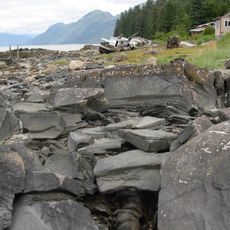
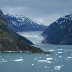
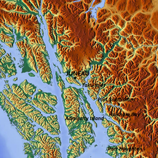
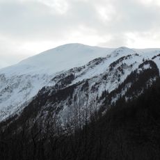
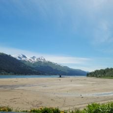
Kootznoowoo Wilderness is a federally designated wilderness area on Admiralty Island in southeastern Alaska, within the Tongass National Forest. It covers dense temperate rainforest, open alpine tundra, and rocky marine coastlines cut by deep fjords and river deltas.

Admiralty Island has been home to Tlingit people for thousands of years before European explorers arrived in the 18th century. In 1980, the Alaska National Interest Lands Conservation Act gave the area its current protected status as a designated wilderness.

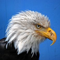
The name "Kootznoowoo" comes from the Tlingit language and means "fortress of the bears," which reflects how central the bear is to local identity. The Tlingit village of Angoon, the only permanent settlement on Admiralty Island, still maintains close ties to the land through fishing and ceremony.

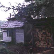
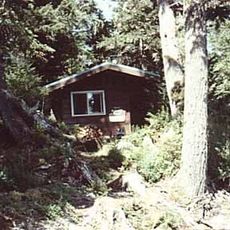
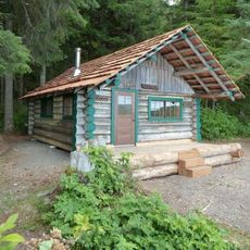
The area has no roads, so reaching it requires a boat or small plane, usually departing from Juneau or Sitka. Public use cabins and canoe routes exist across the island, but advance booking is strongly advised given how remote the terrain is.

Although the island carries an English name honoring a British admiral, the Tlingit have always used their own name for it, and Kootznoowoo remains the name in daily use among local communities. The island is also thought to have roughly one brown bear per square mile (about 2.6 sq km), one of the highest densities anywhere on Earth.

The community of curious travelers

AroundUs brings together thousands of curated places, local tips, and hidden gems, enriched daily by 60,000 contributors worldwide.

Start exploring
Location
GPS coordinates
57.63750,-134.35100
Latest update
March 3, 2026 14:04
Around this place
Alaska State Capitol
United States of America

Alaska State Capitol

74.1 km
United States of America

Tracy Arm

64 km
Red Dog Saloon
United States of America

Red Dog Saloon

73.7 km
Goldbelt Tram
United States of America

Goldbelt Tram

73.4 km
Alaskan Hotel and Bar
United States of America

Alaskan Hotel and Bar

73.8 km
Perseverance Theatre
United States of America

Perseverance Theatre

71.2 km
Juneau-Douglas Bridge
United States of America

Juneau-Douglas Bridge

73.8 km
Alaska State Centennial Museum
United States of America

Alaska State Centennial Museum

73.9 km
Juneau Raptor Center
United States of America

Juneau Raptor Center

73.8 km
Five Finger Islands Light
United States of America

Five Finger Islands Light

59.4 km
Bergmann Hotel
United States of America

Bergmann Hotel

74.1 km
Hurff Ackerman Saunders Federal Building and Robert Boochever US Courthouse
United States of America

Hurff Ackerman Saunders Federal Building and Robert Boochever US Courthouse

74 km
Petroglyph Beach State Historic Park
United States of America

Petroglyph Beach State Historic Park

74 km
Holy Trinity Church
United States of America

Holy Trinity Church

74.1 km
Endicott Arm
United States of America

Endicott Arm

68.6 km
Alaska Steam Laundry
United States of America

Alaska Steam Laundry

73.8 km
Valentine Building
United States of America

Valentine Building

73.9 km
United States of America

Mount Furuhelm

74.1 km
United States of America

Table Top Mountain

73.4 km
Mayflower School
United States of America

Mayflower School

71.1 km
Port Snettisham
United States of America

Port Snettisham

53.4 km
Gastineau Peak
United States of America

Gastineau Peak

72.7 km
MacKinnon Apartments
United States of America

MacKinnon Apartments

74 km
Frances House
United States of America

Frances House

74 km
Distin Lake Shelter Cabin
United States of America

Distin Lake Shelter Cabin

3 km
Alexander Lake Shelter Cabin
United States of America

Alexander Lake Shelter Cabin

12.8 km
Big Shaheen Cabin
United States of America

Big Shaheen Cabin

8.5 km
Sandy Beach
United States of America

Sandy Beach

70.6 km
Show the full map
Reviews
Share your experience

No review yet

Discussions
Start a discussion...

No discussion yet

« Kootznoowoo Wilderness - Federal wilderness area in Southeast Alaska, United States » is provided by Around Us (aroundus.com). Images and texts are derived from Wikimedia project under a Creative Commons license. You are allowed to copy, distribute, and modify copies of this page, under the conditions set by the license, as long as this note is clearly visible.

Discover hidden gems everywhere you go!

From secret cafés to breathtaking viewpoints, skip the crowded tourist spots and find places that match your style. Our app makes it easy with voice search, smart filtering, route optimization, and insider tips from travelers worldwide. Download now for the complete mobile experience.

Around Us App Screenshot

A unique approach to discovering new places

Le Figaro

All the places worth exploring

France Info

A tailor-made excursion in just a few clicks

20 Minutes

Around Us
Travel Guide & Maps
Download

Send to your phone

QR Code
1

Open the camera app on your mobile.

2

Point at the QR code with your camera. A notification will appear.

3

Tap the notification to open the link.