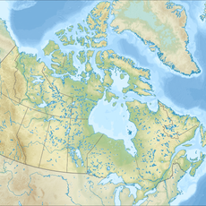
Region 2, Northwest Territories, division de recensement aux Territoires du Nord-Ouest
Location: Northwest Territories
GPS coordinates: 65.28111,-126.83139
Latest update: March 2, 2025 21:31
Nahanni National Park Reserve
413 km
Dempster Highway
447.6 km
Aklavik
485.4 km
Délı̨nę
159.3 km
Midnight Sun Mosque
457.4 km
Tuktut Nogait National Park
451.1 km
Paulatuk
468.2 km
Tulita
72.5 km
Virginia Falls
412.6 km
Aurora College
456.1 km
Mount Nirvana
381.6 km
Colville Lake
198.4 km
Nahanni Butte
503.4 km
Nááts'įhch'oh National Park Reserve
344.5 km
Fort Confidence, Northwest Territories
393.9 km
Keele Peak
265.9 km
Church of Our Lady of Good Hope
136.1 km
Saoyú-ʔehdacho
266.2 km
The Ramparts
139 km
Sans Sault Rapids
102.3 km
Keno City Mining Museum
432 km
Great Bear Magmatic Zone
485.6 km
Fort McPherson National Historic Site of Canada
431.8 km
Ehdaa
467.7 km
Déline Fishery
158.5 km
Nagwichoonjik
391.7 km
McKinnon Territorial Park
5.2 km
Norman Wells A
1.5 kmReviews
Visited this place? Tap the stars to rate it and share your experience / photos with the community! Try now! You can cancel it anytime.
Discover hidden gems everywhere you go!
From secret cafés to breathtaking viewpoints, skip the crowded tourist spots and find places that match your style. Our app makes it easy with voice search, smart filtering, route optimization, and insider tips from travelers worldwide. Download now for the complete mobile experience.
A unique approach to discovering new places❞
— Le Figaro
All the places worth exploring❞
— France Info
A tailor-made excursion in just a few clicks❞
— 20 Minutes