Enable Location

We need your location to show you interesting places around you

Discover nearby places

Find interesting locations and hidden gems around you

Precise directions

Get accurate directions and distances to places

Your location is never shared with other users. It's only used when you tap the location button.

Lake Lawtonka

Log in to your account

Start exploring — it's free

Trusted by 62,114 travelers worldwide

Continue with Google
Continue with Apple
or

We will send you a code to connect

By continuing, you accept our Terms and Conditions and our Privacy Policy

Check your inbox

We've sent a pincode in your inbox. Please enter the code below.

Lake Lawtonka

Lake Lawtonka, reservoir in Oklahoma, United States

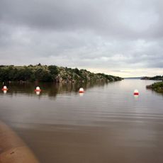
Lake Lawtonka is a large reservoir in southwest Oklahoma covering more than 2,400 acres with a varied shoreline offering multiple activity zones. The water varies in depth across different areas, creating spots suitable for boating, fishing, and swimming in designated sections.

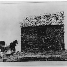
The lake was established in the early 1900s to supply water to nearby towns and military bases, with the original dam built in 1905. The larger dam constructed in 1939 replaced it and remains the dominant structure controlling water levels in the area.

The lake's name comes from the early settlement period and refers to the nearby Lawton region. Today it serves as a gathering place where locals and visitors spend time together, enjoying simple outdoor traditions like fishing and picnicking by the water.

The lake sits about 7 miles northwest of Lawton via Highway 44 then west on Highway 49, or just north of Medicine Park on Highway 58. Access roads are well-marked with designated areas for boat ramps, swimming beaches, picnic zones, and campgrounds equipped with parking and restrooms.

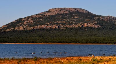
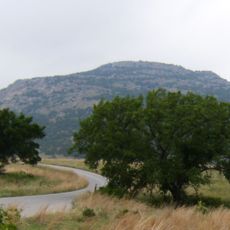
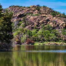
The lake features a sandy swimming beach facing Mount Scott, a tall mountain that provides a striking natural backdrop for visitors. The gently sloping shallow water makes this beach particularly safe for children and beginners compared to other regional water spots.

The community of curious travelers

AroundUs brings together thousands of curated places, local tips, and hidden gems, enriched daily by 60,000 contributors worldwide.

Start exploring
Location
GPS coordinates
34.75590,-98.50410
Latest update
February 7, 2026 11:00
Around this place
Fort Sill
United States of America

Fort Sill

5.8 km
Quanah Parker Star House
United States of America

Quanah Parker Star House

18.5 km
Mount Scott
United States of America

Mount Scott

2.9 km
Wichita Mountains Wildlife Refuge
United States of America

Wichita Mountains Wildlife Refuge

18 km
Signal Mountain Blockhouse
United States of America

Signal Mountain Blockhouse

9.2 km
Great Plains State Park
United States of America

Great Plains State Park

44 km
United States of America

Fort Cobb

39.8 km
Comanche Nation Casino
United States of America

Comanche Nation Casino

20.7 km
Chisholm Trail Casino
United States of America

Chisholm Trail Casino

52.7 km
Tom Steed Reservoir
United States of America

Tom Steed Reservoir

44.4 km
Apache Casino Hotel
United States of America

Apache Casino Hotel

21.2 km
Mattie Beal House
United States of America

Mattie Beal House

20.5 km
United States of America

Charon's Garden Wilderness Area

21.2 km
Southern Plains Indian Museum
United States of America

Southern Plains Indian Museum

43.1 km
Museum of the Great Plains
United States of America

Museum of the Great Plains

18.2 km
First Christian Church
United States of America

First Christian Church

19.4 km
Carnegie Library
United States of America

Carnegie Library

19.4 km
First Baptist Church
United States of America

First Baptist Church

43.4 km
First United Methodist Church
United States of America

First United Methodist Church

47.7 km
Brittain-Garvin House
United States of America

Brittain-Garvin House

57.2 km
H.C. Chrislip House
United States of America

H.C. Chrislip House

56.4 km
Mahoney-Clark House
United States of America

Mahoney-Clark House

19.1 km
Chisholm Trail Heritage Center & Garis Gallery of the American West
United States of America

Chisholm Trail Heritage Center & Garis Gallery of the American West

54.7 km
Holy City of the Wichitas Historic District
United States of America

Holy City of the Wichitas Historic District

8.1 km
Historic Mattie Beal Home
United States of America

Historic Mattie Beal Home

20.5 km
Shepler Square Park
United States of America

Shepler Square Park

19.3 km
Lawton Federal Building and United States Courthouse
United States of America

Lawton Federal Building and United States Courthouse

19.7 km
Liberty Theatre
United States of America

Liberty Theatre

40 km
Show the full map
« Lake Lawtonka - reservoir in Oklahoma, United States » is provided by Around Us (aroundus.com). Images and texts are derived from Wikimedia project under a Creative Commons license. You are allowed to copy, distribute, and modify copies of this page, under the conditions set by the license, as long as this note is clearly visible.

Discover hidden gems everywhere you go!

From secret cafés to breathtaking viewpoints, skip the crowded tourist spots and find places that match your style. Our app makes it easy with voice search, smart filtering, route optimization, and insider tips from travelers worldwide. Download now for the complete mobile experience.

Around Us App Screenshot

A unique approach to discovering new places

Le Figaro

All the places worth exploring

France Info

A tailor-made excursion in just a few clicks

20 Minutes

Around Us
Travel Guide & Maps
Download

Send to your phone

QR Code
1

Open the camera app on your mobile.

2

Point at the QR code with your camera. A notification will appear.

3

Tap the notification to open the link.