Chest opened
+${chestReward.xp} XP
Explorer
NOUVEAU ×${chestReward.collectible.quantity}
tapez pour fermer
Chest locked

Open chests in the app

Around Us is built for your phone — chests unlock when you walk, explore and capture nearby places.

Enable Location

We need your location to show you interesting places around you

Discover nearby places

Find interesting locations and hidden gems around you

Precise directions

Get accurate directions and distances to places

Your location is never shared with other users. It's only used when you tap the location button.

Log in to your account

Start exploring — it's free

Trusted by 72,889 travelers worldwide

Continue with Google
Continue with Apple
or

We will send you a code to connect

By continuing, you accept our Terms and Conditions and our Privacy Policy

Check your inbox

We've sent a pincode in your inbox. Please enter the code below.

Discussion Reviews Photo
1.5k Popularity

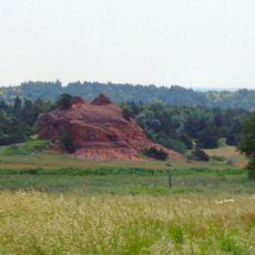
Devil's Canyon, National Natural Landmark in Canadian County, Oklahoma.

Devil's Canyon is a protected natural landmark in Canadian County featuring oak woodlands, tall prairie grass, and eastern deciduous forest. These different vegetation types create a complex ecological environment where multiple ecosystems overlap.

The National Park Service designated this site as a National Natural Landmark in 1974 to protect its ecological significance. This recognition marked the formal acknowledgment of its distinctive natural qualities.

The site preserves plant species found nowhere else nearby, representing Oklahoma's natural diversity. Visitors can observe how different habitats exist side by side in this landscape.

The site is under private ownership with restricted access to specific areas. Always check current access rules before planning your visit to understand what parts are available to explore.

The site hosts mesic plants that thrive in both dry and moist conditions. This adaptability allows the canyon to support multiple ecosystem types simultaneously in one location.

The community of curious travelers

AroundUs brings together thousands of curated places, local tips, and hidden gems, enriched daily by 60,000 contributors worldwide.

Start exploring
Location
GPS coordinates
35.36330,-98.34170
Latest update
December 9, 2025 20:20
Around this place
University of Science and Arts of Oklahoma
United States of America

University of Science and Arts of Oklahoma

51 km
Fort Reno
United States of America

Fort Reno

35.5 km
Stafford Air & Space Museum
United States of America

Stafford Air & Space Museum

36 km
United States of America

Fort Cobb

29.5 km
El Reno High School
United States of America

El Reno High School

39.7 km
Red Rock Canyon State Park
United States of America

Red Rock Canyon State Park

9.6 km
Darlington Agency
United States of America

Darlington Agency

38.3 km
Rock Mary
United States of America

Rock Mary

13.2 km
Southern Plains Indian Museum
United States of America

Southern Plains Indian Museum

33.8 km
Mennoville Mennonite Church
United States of America

Mennoville Mennonite Church

46.3 km
Canadian County Jail and Stable
United States of America

Canadian County Jail and Stable

39.9 km
Yukon Public Library
United States of America

Yukon Public Library

55.9 km
El Reno Municipal Swimming Pool Bath House
United States of America

El Reno Municipal Swimming Pool Bath House

38.7 km
Carnegie Library
United States of America

Carnegie Library

40 km
First Baptist Church
United States of America

First Baptist Church

33.2 km
West Point Christian Church
United States of America

West Point Christian Church

50.6 km
New Hope Baptist Church
United States of America

New Hope Baptist Church

52 km
Henry Lassen House
United States of America

Henry Lassen House

40.2 km
El Reno Hotel
United States of America

El Reno Hotel

39.7 km
Red Cross Canteen
United States of America

Red Cross Canteen

39.4 km
United States Post Office Watonga
United States of America

United States Post Office Watonga

54 km
William I. and Magdalen M. Goff House
United States of America

William I. and Magdalen M. Goff House

39.6 km
Meloy House
United States of America

Meloy House

56 km
Blaine County Courthouse
United States of America

Blaine County Courthouse

54.1 km
Richardson Building
United States of America

Richardson Building

37.1 km
Mulvey Mercantile
United States of America

Mulvey Mercantile

56.5 km
Verden Separate School
United States of America

Verden Separate School

51.7 km
Historic Fort Reno Visitors Center
United States of America

Historic Fort Reno Visitors Center

35.6 km
Show the full map
Reviews
Share your experience

No review yet

Discussions
Start a discussion...

No discussion yet

« Devil's Canyon - National Natural Landmark in Canadian County, Oklahoma » is provided by Around Us (aroundus.com). Images and texts are derived from Wikimedia project under a Creative Commons license. You are allowed to copy, distribute, and modify copies of this page, under the conditions set by the license, as long as this note is clearly visible.

Discover hidden gems everywhere you go!

From secret cafés to breathtaking viewpoints, skip the crowded tourist spots and find places that match your style. Our app makes it easy with voice search, smart filtering, route optimization, and insider tips from travelers worldwide. Download now for the complete mobile experience.

Around Us App Screenshot

A unique approach to discovering new places

Le Figaro

All the places worth exploring

France Info

A tailor-made excursion in just a few clicks

20 Minutes

Around Us
Travel Guide & Maps
Download

Send to your phone

QR Code
1

Open the camera app on your mobile.

2

Point at the QR code with your camera. A notification will appear.

3

Tap the notification to open the link.